
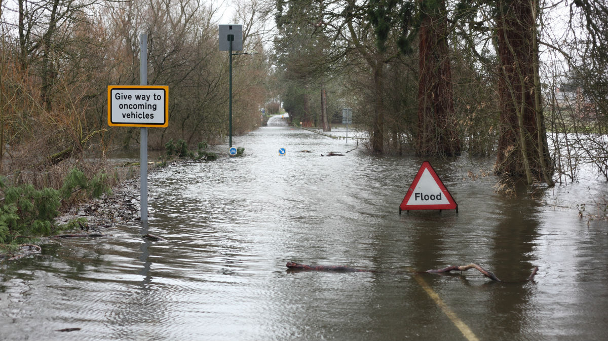
The very wet and at times windy weather continues, and with more heavy rain in the offering over the next few days on already sodden ground, more warnings of flooding will undoubtedly come.
The very wet and at times windy weather continues, and with more heavy rain in the offering over the next few days on already sodden ground, more warnings of flooding will undoubtedly come.
Not only that, a new moon on Saturday and a lunar perigee on Monday (the moons closest approach to earth) will also produce higher tides. Alongside this, for a time into the new working week, a North West wind giving gusts over 50mph in the North Sea may cause somewhat of a storm surge, putting some coastal areas at risk of perhaps more serious flooding.
Eastern areas will see some sunshine at first, but we already have a fair number of showers mainly in the West that'll soon spread East this morning. Some of the showers will be heavy and lengthy, giving thunder locally as they rattle through on a blustery South West wind that'll be strongest in the South. Over Scotland, Northern Ireland and the far North of England however winds will be lighter. So the showers will be slow-moving with a few giving local torrential downpours and also some thunder. Top temperatures of 12 to 15C in the North and 16 to 19C elsewhere, will be slightly down on yesterday's values in the East and South.
A storm forecast has been issued for today.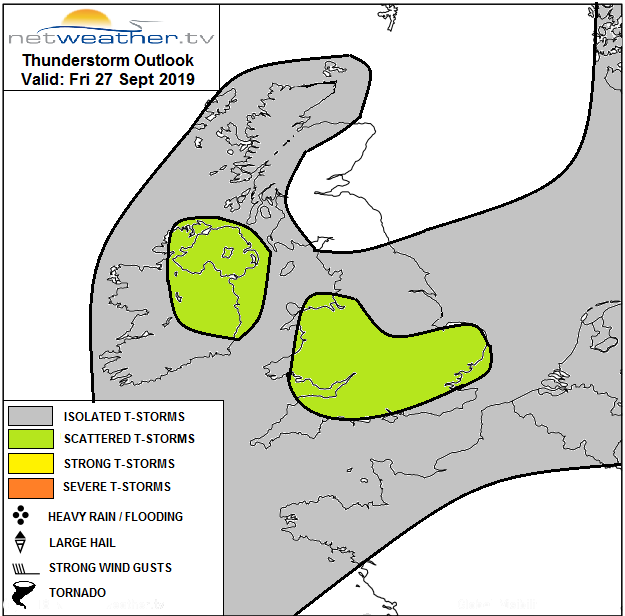
There'll be a further scattering of showers across the country into the evening and after dark, as a depression crosses Scotland. There could also be more prolonged spells of rain over Northern Ireland, Dumfries and Cumbria for a time. A blustery South West wind will give gusts to gale force along the South coast but will continue to be lighter over much of Scotland. Sheltered eastern areas, in particular, will see skies breaking at times to give a few clear intervals perhaps. A few Scottish glens will potentially turn quite cold towards dawn, but generally, temperatures shouldn't fall below 7 to 12.C.
Saturday remains unsettled, but with fewer showers and more in the way of sunny spells especially in southern and eastern areas. The showers could still be heavy and lengthy for a while though in northern regions, before tending to fade through the afternoon as a brief lull moves in from the West. A blustery West or South-West wind will also decrease somewhat, 'backing' southerly later ahead of another Atlantic depression moving in from the South West. That'll be bringing outbreaks of rain to Cornwall and Devon before evening. Top temperatures 11 to 14C over Scotland and Northern Ireland and 15 to 18C further South.
Saturday evening sees a brief lull in the East and North East, but rain already in the South West will spread to the whole of England, Wales and to parts of Northern Ireland and perhaps southern Scotland after dark. The rain will be heavy in places accompanied by a freshening Southerly wind that'll be giving gusts to 50 to 55mph along parts the South coast by the early hours.
Over remaining parts of Scotland, you'll see a mix of clear intervals and scattered showers. With lighter winds here, a few sheltered glens could also turn quite chilly again. Temperatures on the whole though should fall no lower 8 to 12C, with a very mild 13 to 15C more likely in the South.
While there's uncertainty as to the track of the depression as it crosses the country on Sunday, most places will undoubtedly be very wet for a time leading to further flooding problems. Blustery winds of Arctic origin on Monday will then see September out on a colder note, perhaps with a slight frost in some Scottish glens early on Tuesday morning to greet the new month. Most models then continue the very unsettled theme into early October, but I suspect that through next week, that it may become somewhat drier and warmer towards the South East.


.jpg?w=350)

