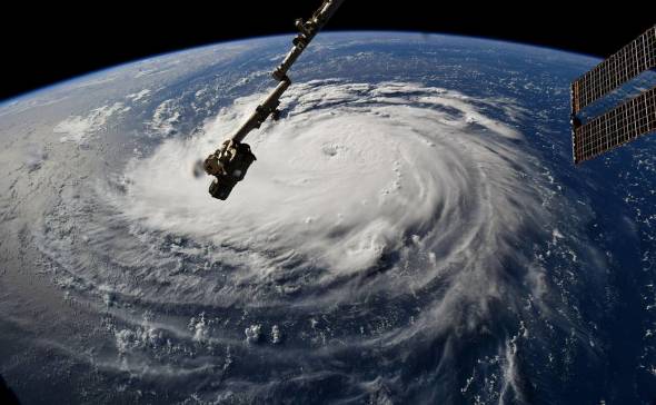
Hurricane Florence as seen from the International Space Station on Monday afternoon. (Photo/NASA Astronaut Ricky Arnold)
*UPDATE 3PM THURSDAY 13TH SEPTEMBER - FLORENCE TO MAKE NORTH CAROLINA LANDFALL BY FRIDAY*
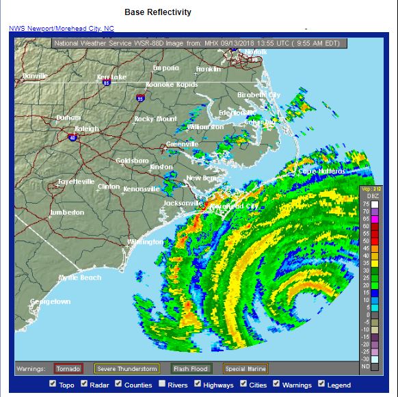
The eye of Hurricane Florence can now be seen on North Carolina rainfall radar a few 100 miles out over the Atlantic, the outer bands of rainfall moving over the barrier islands and now touching the mainland coast.
Hurricane Florence has weakened into a category 2 storm as it barrels towards the North Carolina coast, yesterday afternoon it was category 4. The weakening of the wind strength is attributed to a slight increase in wind shear and entrainment of dry aloft – both of which tend to be unfavourable for maintaining hurricane strength.
While the wind speeds have weakened, the actual field of hurricane force winds have expanded, with potentially increasing area of hurricane force winds likely to hit the coastal areas of the Carolinas later on today.
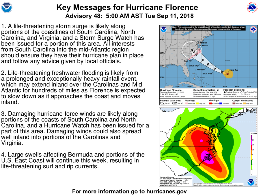
Of greater concern now is the threat of life-threatening storm surge along the coasts of North Carolina and South Carolina, a product of the low central pressure of Florence (956mb as of 12pm UTC) causing the Atlantic ocean to bulge toward the centre of the hurricane combined with the large swells created by the hurricane force winds out over the Atlantic. The storm surge could be as much as 9-13 feet on the north side of the hurricane, where the hurricane force wind will be onshore, as it makes landfall.
Perhaps of more concern for areas inland of the coasts of the Carolinas, but not limited to inland, is the extreme heavy rainfall that Florence will bring, which will be prolonged as the storm slows as it makes landfall along the Carolinas. Catastrophic flash flooding and severe river flooding will be likely - some locations towards coastal North Carolina near the landfall of Florence could receive over 2 feet of rainfall by early next week.
Not only are there the threats of hurricane force winds, storm surge and rainfall flooding, parts of coastal North Carolina are under a tornado watch for 14 hours, as unstable warm and humid air moving onshore combines with increasing low level shear on the northern side of the hurricane landfall.
------------------------------------------------------------------------------------------------------------------------------------------------------------------------
PREVIOUS DISCUSSION
The tropical Atlantic and tropical Pacific will be very busy this week, with preparations underway as Hurricane Florence threatens the Carolinas later this week, while Tropical Storm Issac threatens the Leeward Islands of the eastern Caribbean later this week. Hurricane Helene stays out over the eastern Atlantic as it swings north this week towards the Azores by the weekend and last but not least over the central Pacific Tropical Storm Olivia draws closer towards the Hawaiian Islands, threatening flooding.
Hurricane Florence will be the biggest threat out of all these tropical systems, currently a major category 4 Hurricane with sustained winds of 140 mph, moving west-northwest towards southeasten U.S.A., with landfall expected along the Carolinas sometime on Thursday.
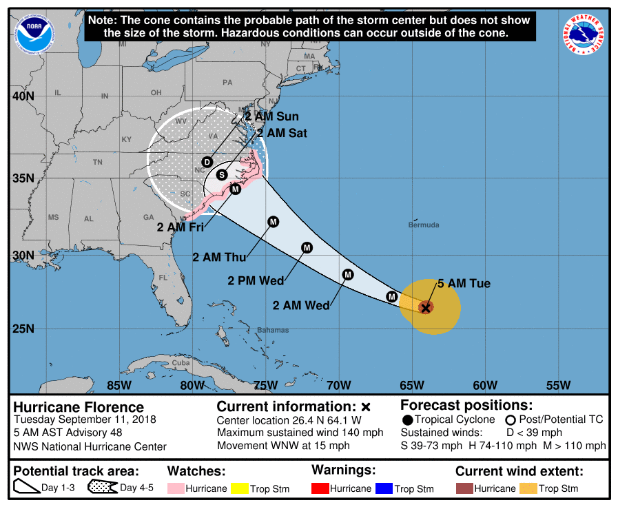
Currently Florence has a well-defined eye and symmetrical structure, indicating further strengthening likely, which will be aided by low wind shear and warmer waters between where it is now and the coast of the Carolinas compared to where it has been, with little to weaken Florence, other than eye-wall replacement as it approaches land. Forecasts indicated potential for strengthening towards category five hurricane over the next 48 hours, though increasing southwesterly shear over SE U.S.A make cause a little weakening before landfall.
The track of Florence is unusual in that its track has been farther north over the Atlantic than any other hurricane to hit the Carolinas, making forecasting it’s track, speed and impacts vs historic storm impacts all the more challenging. Most hurricanes in the past moving into the Carolinas have moved north from Florida.
Major Hurricane Florence entering stage right and barreling towards the Carolinas:
The exact track of Florence is still changing though, latest 00z ECMWF ensemble guidance points to a southward shift for landfall along South Carolina coast rather than North Carolina coast as per previous guidance. Tropical disturbance 95L over the northwest Caribbean influence on the strength of the ridge over southeastern U.S. may also be leading to uncertainty over Florence’s track as she makes landfall. Perhaps why the latest ECMWF guidance may be adjusting.
Despite the uncertainty in track and strength still, wherever Florence makes landfall along the Carolinas, it may potentially be the most destructive hurricane to hit the Carolinas in decades. Here are the current key messages from the U.S. National Hurricane Center:
Current thinking from forecasters is that Florence may make landfall along the Carolinas as a category 3 or even 4 storm on Thursday, which on the Saffir-Simpson Hurricane Wind Scale means sustained winds of 111-129mph if cat 3 or 130-156 mph if cat. 4, with higher gusts - which is capable of devastating to catastrophic damage from damaging winds, flooding and coastal storm surge. The other concern is Florence will slow down or even stall along or inland of the coast, which will potentially lead to a life-threatening flooding situation.
I will update this blog for the rest of the week and into the weekend as Florence rolls towards then impacts southeast U.S.A, meanwhile, here are some links to follow the latest on Florence
Loading recent activity...