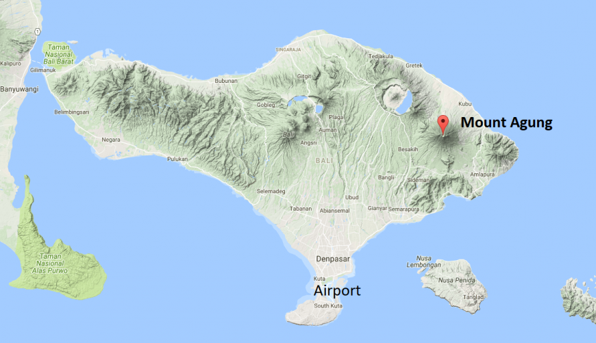
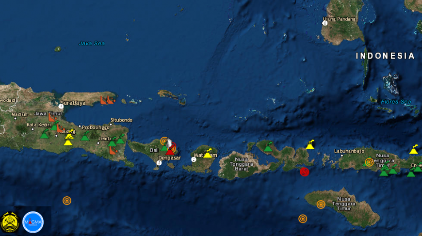
Mount Agung is erupting, as it did in September and again with concerns of a larger eruption. The main Bali airport is closed and tens of thousands of people are being evacuated. Indonesia sits along a volatile seismic strip called the ‘Ring of Fire’. where an oceanic plate is being forced under a continental plate thanks to the world's tectonic motions. Volcanic eruptions and earthquakes occur regularly and tsunamis are possible across Indonesia but this is on the tourist island of Bali, so is attracting international attention.
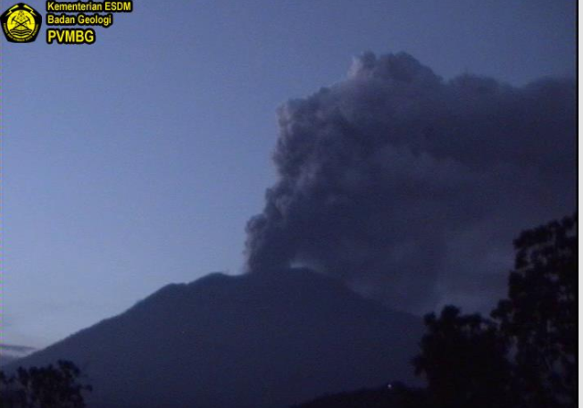
Continuous ash puffs are sometimes accompanied by explosive eruptions accompanied by a weak sound that sounds up to 12 km from the summit. The rays of fire are increasingly observed in the next night. This indicates the potential for a larger eruption is imminent. Communities around Mount Agung and climbers / visitors / tourists not to be on, do not climb and do not do any activity in the Estimate Zone of Hazard that is inside the crater area of Mount Agung and in all areas within 8 km from the crater of G. Agung
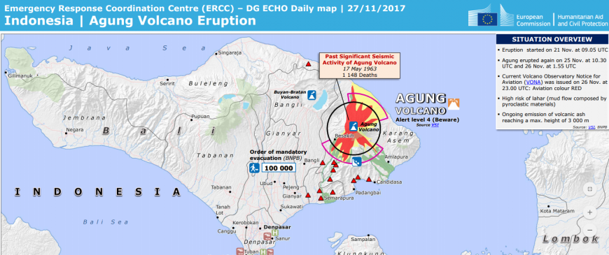
Back in September 2017, the National Disaster Management Authority for Indonesia raised the volcanic alert level for the Mount Agung volcano in north east Bali to level 4, the highest level possible, which it is now at once more. The earth has been giving out warnings.
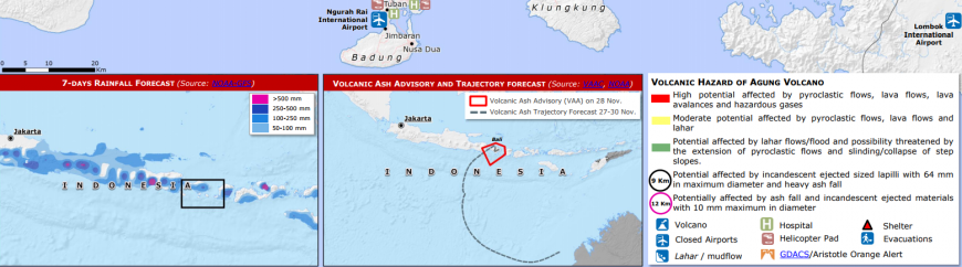
Past eruptions of Mount Agung have shown this volcano's potential to cause significant impacts to the island of Bali, including the potential for widespread ash fall outside the declared danger area surrounding the volcano. Depending on the weather conditions at the time of an eruption, an ash cloud could affect flights and ash fall may impact Denpasar and neighbouring airports in East Java and Lombok, causing widespread disruption to the travelling public.
.
This week Agung produced more volcanic activity, resulting in extra advice to travellers.
Latest advice, 27 November 2017 Australian gov
Mount Agung, an active volcano in Karangasem Regency in East Bali, has emitted ash from eruptions since 21 November 2017. Volcanic activity may escalate with little or no notice. On 27 November, Bali airport closed and depending on weather conditions the ash cloud could close other airports in Indonesia. Contact your airline or tour operator for up-to-date information (see Additional Information). On 27 November, the alert warning level issued by Indonesia's National Disaster Management Authority was raised to level 4 of 4. Monitor local media reports, follow the instructions of local authorities and stay outside the exclusion zone around the crater. Contact your airline or tour operator directly for up-to-date information on flight options.
There are two paths with the warnings, one to the people who live and farm in the area and the other to visitors, mostly holidaymakers. Signs have been in place since September and there are sirens around the exclusion radius.
There have already been evacuations ordered by the Indonesian government, with nearly 10.000 people displaced in Sept as the exclusion zone expanded from 9 to 12 kms in places. Local people had to stay in shelters but often returned home in the daytime to feed their livestock. Cows are a valuable asset for the community. They have become a part of life and culture for people around the mountain. This makes it difficult for people to evacuate fully.
At the end of Sept seismic activity continued to escalate, and diffuse white plumes rose 50 m above the crater rim, yet it did then subside.
This time ash and smoke are appearing. There was a thick ash puff with medium pressure, ash column as high as 1,500 meters from a crater that was bent toward the southwest. Until 23:00 WITA, smoke and volcanic ash are still monitored out of the crater with the spread of volcanic ash leads to the southwest in accordance with the wind direction. There has been ash detected at the airport in the south of the Island.
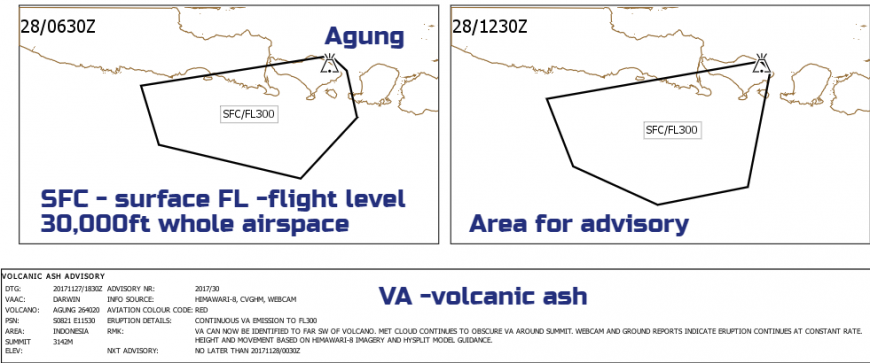
Globally there are nine volcanic ash advisory centres (VAACs) that detect, track and forecast the movement of volcanic ash clouds and provide advice to meteorological offices in their area of responsibility. The VAACs are located in the USA, Argentina, UK, Australia, Japan, France, Canada and New Zealand. The Bureau’s VAAC (known as VAAC Darwin) is responsible for an area that includes the volcanically active regions of Indonesia, and have issuing advice already.
What is volcanic ash?
Volcanic ash is composed of fine particles of fragmented volcanic rock (less than 2 mm diameter). Volcanic ash is often hot very close to the volcano but is cool when it falls at greater distances. It is formed during volcanic explosions, from avalanches of hot rock that flow down the side of volcanoes, or from red-hot liquid lava spray. Ash varies in appearance depending upon the type of volcano and the form of the eruption. Thus, it can range in colour from light grey to black and can vary in size from being like grit to being as fine as talcum powder. Airborne ash blocks out sunlight, reducing visibility and sometimes causes complete darkness during daylight. Large ash deposits can incorporate into existing soils and become the future topsoil of a volcanic region. The fertility of the soils around many volcanoes is due to old ash deposits. This beneficial effect of volcanism outweighs, over time, the hazards. Eruptions can also generate thunder and lightning from friction between the fine, airborne particles which can be localised above the volcano or accompany large ash plumes as they move downwind. from infrequent eruptions, so fertile volcanic areas are often densely populated
Advice on what to do before, during and after an eruption
What can it do to you?
Effects of ash on health may be divided into several categories: respiratory effects, eye symptoms, skin irritation and indirect effects. Freshly fallen ash particles can have an acid coating which may cause irritation to the lungs and eyes. This acid coating is rapidly removed by rain, which may then pollute local water supplies leading to other problems, Acidic ash can also damage vegetation, leading to crop failure so longer term issues.
There has been a recent update to advice about facemasks relating to the expected eruptions in Bali. This is a major part of emergency planning on the island.
Health Interventions in Volcanic Eruptions (HIVE) project concluded that well fitting, good quality face masks did make a difference and that using bandanas, or wetted clothing were not good enough. This advice was issued to try to reduce long-term health impacts after a volcanic event. Even after the event, cleaning up is not a straightforward job, where should all the ash go, care is needed to clean it out of the house, it is likely to have wrecked many things, and the weather conditions can ease the cleanup or make it even worse.
After an eruption- Clearing up ash
Even after the actual eruption event and the ash plume has ended, there will be a lot of ash lingering. Volcanic ash is a great nuisance and gets everywhere in homes and workplaces, including inside televisions, computers, cameras and other valuable equipment, where it can cause irreparable damage. Ash is different from ordinary dust. Its sharp, crystalline structure causes it to scratch and abrade surfaces when it is removed by wiping or brushing. In wet weather, the ash deposits are dampened down and the air can be clear, but in drier weather ash can easily be stirred up and remobilised by wind and traffic. As a result, suspended dust levels become much higher and can reach levels potentially harmful to health. Rainfall and wind are effective in removing the ash and grass and other plants will eventually bind it to the soil, but with large ashfalls this process is too slow and the ash must be cleaned up and taken away from populated areas. In addition, wind may also bring ash into areas which were previously clean so ash may be present in the environment for months or even years following an eruption.
Webcam of Agung top image
Icelandic volcano - Katla and UK summer holiday flights
Loading recent activity...