Issued at 1500BST on Tue 13th June based on Tue 13th June 00Z Model Runs
Key Points
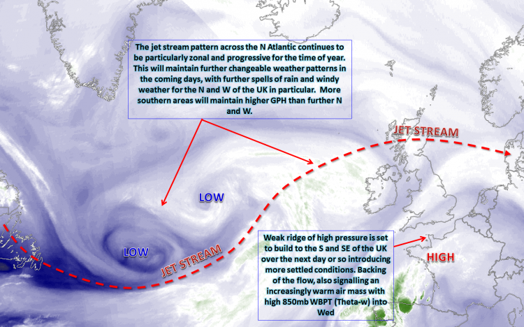
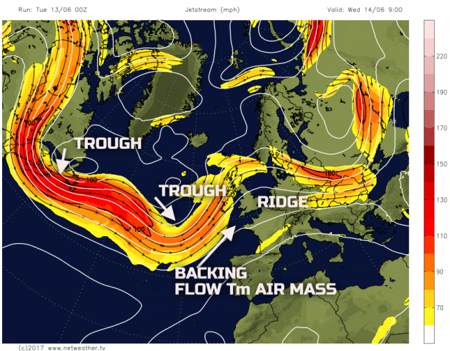
Discussion:
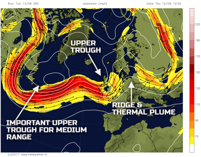
Wed 14th June: Into Wednesday and there is a good model agreement between the ECMWF, UKMO, GFS and GEM, along with the HRES models, for an upper trough to be approaching from the W and SW of the UK. Downstream of this, over and just to the S and SE of the UK will be a temporary rise in GPH. The backing of the flow across the British Isles through Wednesday, as the trough approaches, means a marked 850mb theta-w plume across the UK and so one of the warmest days, in quite some time, will arrive. The overall flow though across the N Atlantic and into NW Europe remains a rather zonal and progressive one, so this development of very warm conditions will be short-lived.
The resultant weather through the day will be for fair weather conditions to dominate with bright or sunny spells. There will be reasonably subsided profiles across England and Wales, so while some convective infill is likely, there will also be prolonged spells of sunshine. The approaching upper trough from the W and SW will be associated with a low surface pressure and its associated frontal zones. These fronts will, later in the day, move into W Scotland and Ireland bringing more unsettled weather here. There is also a low risk across parts of N England and NE England of a few isolated heavy showers later on, primarily driven by surface convection and then the approaching upper trough.
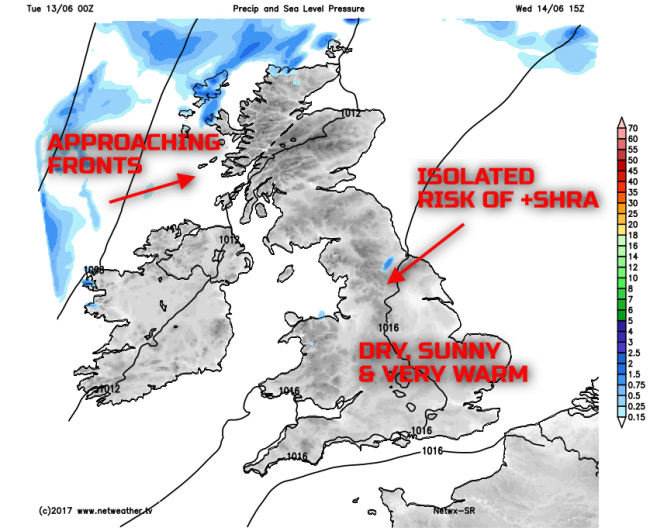
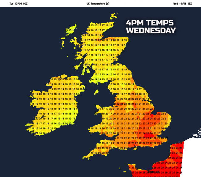
It will be the warmest day in quite some time with temperatures widely 16C to 20C across Scotland and Ireland and between 18C and 22C across England and Wales. However, some central and southern counties of England will likely see temperatures rise to 23C to 25C through the afternoon, depending on local and regional cloud amounts.
Thu 15th June: Through into Thursday and, overall, the model agreement continues regarding the synoptic evolution and the progressive pattern. The upper trough which will aid in the backing of the flow on Wednesday will move across the UK during Thursday leading to the significant warmth. This will introduce a more cyclonic flow with associated frontal zones moving eastwards through the day too. However, it will also displace the main 850mb thermal plume eastwards. Importantly, upstream, will be yet another trough moving out of E Canada. This one does bring with it uncertainty within the models. However, what the models do agree on is that it will be important in the development of anticyclogenesis, downstream, across the UK towards the end of the week and into the weekend. The trough will have significant implications on the weather for the weekend as to just how settled, or not; the weather may well become.
The weather during Thursday will be characterised by a warm and humid start, across many central, southern and eastern areas of England after an unusually warm night on Wednesday. However, a frontal zone across Scotland and Ireland first thing will quickly move eastwards into N England and Wales bringing some rain. There is a good model agreement between the ECMWF, GFS, GEM and the UKMO for this front to be lacking any significant forcing and, as a result, no widespread heavy rain is forecast. However, and importantly, the frontal zone will be a cold front, and it will introduce the cooler and fresher conditions from the W through the day. Following the rain will be showery conditions across Scotland and Ireland during the afternoon, but for much of central and southern areas of England another decent day, plenty of dry weather with some sunshine, but noticeably cooler.
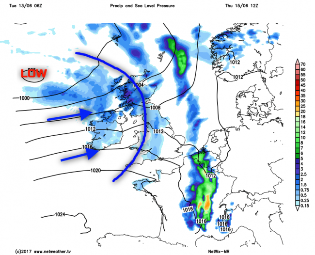
The introduction of the cooler, fresher air mass is highlighted well by 850mb temperatures for example. Note values more than +10C just to the E and SE of England, of which was Wednesday’s heat. Following is 850mb temperatures near or below +5C into many N and W areas behind the eastward moving cold front.

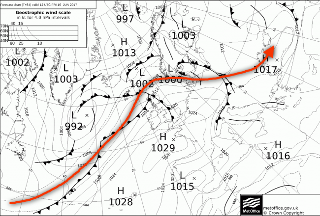
Fri 16th June: We end the working week with, again, good model agreement. The extending upper trough over the W Atlantic will be directly responsible for amplifying the pattern, downstream, across NW Europe. However, quite an active and noteworthy jet stream for the time of year will be running up towards the N of the British Isles through the day. As a result, an increasingly N and S divide in conditions will develop. Rising GPH across many central and southern areas of England means yet another fair weather day, with some bright or sunny spells and pleasantly warm too. However, in contrast, for much of Scotland, Ireland and N England it will be cloudier, windier and with frontal zones moving E during the day to bring about some precipitation, albeit relatively light.
.png?w=650)
The 00Z UKMO modified fields (FAX) highlight the Synoptics well for Friday. The connection between the upper pattern and the surface is perfect to see. Note the building ridge, NE, an extension of the Azores high across many central and southern areas, leading to a reasonable day. However, the low pressure just to the NW and its frontal zones bring rather different conditions, through the day, across the N and W. The jet stream is overlaid for extra clarity.
Sat 17th and Sun 18th June: So, we move into the coming weekend with an increasingly amplified pattern across the N Atlantic, but this is when model divergence becomes apparent. This particular synoptic pattern is often shrouded in uncertainty because the flow can be both cyclonic, across parts of the N and W, but equally anticyclonic across the S and E. It is often difficult for forecast models to determine how much of each is likely across the UK and the coming weekend is no different.
Taking a look at the 00Z GM’s for T+120hr, so 0000Z Sun 18th, you can see there are differences over the amplification of the pattern across the UK. The most amplified being the ECMWF; this has got the majority of the UK beneath an anticyclone and all the usual conditions that will arrive at this time of year. However, the UKMO and GFS, for example, don’t extend the ridge as far N as the 00Z ECMWF, with more of a cyclonic W’ly or even WNW’ly flow from the GFS, across parts of the N and W of the UK. This variation is unlikely to be resolved for a few days yet.
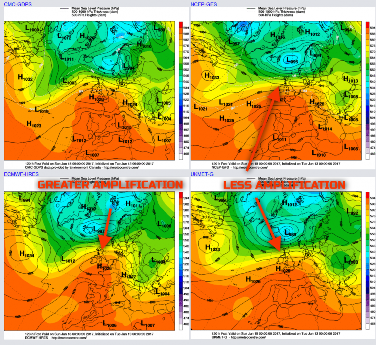
However, trying to put some detail on to the forecast and, from experience too, that it is likely that Scotland and Ireland will be unsettled. The flow is more cyclonic here over the weekend leading to cloudier conditions, perhaps with some relatively light or moderate frontal precipitation too. However, for much of central and southern areas of England and Wales, at least, it looks a decent weekend. Bright or sunny spells and with a returning Tm air mass then temperatures will likely be on the rise with it becoming warm or very warm again. N England is an unusually uncertain region as this area will be on the boundary of these two weather types, so potentially mainly dry for N England, but if the flow is less amplified than even N England may have a rather cloudy weekend, with perhaps some precipitation developing at times.
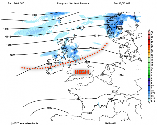
Our MR weather model highlights this general division quite well, noting some precipitation the further N you are, along with lower atmospheric pressure, while across much of England and Wales the pattern is anticyclonic. There is a chance that the likes of the 00Z ECMWF may well be right and there are a number of its ENS members that support a greater dominance of high pressure across the whole of the UK. However, there are some that don’t, so it’s a case of ‘time will tell’ in the coming days just how far north any decent weather will get.
Medium and Longer Term 19th June onwards:
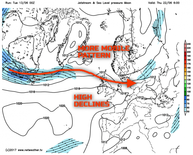
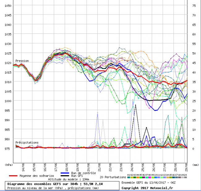
Looking further ahead and confidence drops away markedly. This, to an extent, relates to what will happen this coming weekend. It does look as though a more anticyclonic period will dominate, at least for a time and at least across England and Wales into early next week. However, the current thinking is the high pressure will decline to the S of the UK. What may well happen then is for an overall drop in GPH across the UK as we progress through towards the final week or so of June, allowing for a more progressive pattern and hence more cyclonic conditions to develop. The 00Z GFS ENS for Thu 22nd highlights this evolution as things stand, but the emphasis is on low confidence.
Finally, supporting this idea is the latest (06Z 13Jun17) GFGS ENS data as well. While it is a gradual and stepped process, taking N England as an example, you can see that overall from the middle of the month onwards pressure does gradually decline and this also coincides with an increasing precipitation signal too. As a result, in summary, a more unsettled end to June is the most likely option at the moment, perhaps with some thundery conditions.
Loading recent activity...


.png?w=1200)