


An area of low pressure, named Storm Bruna, is located to the northwest of Spain Tuesday afternoon, its northern most fronts are bringing a band of rain slowly northeast across England and Wales over the next 12 hours, while bringing heavy rain, strong winds, and rough seas along the Atlantic coast of the Iberian Peninsula and the Canary Islands. 120-150 mm of rain are forecast in 12 hours while very strong gusts are affecting higher elevations of the main mountain ranges in the north and center of the Iberian Peninsula.
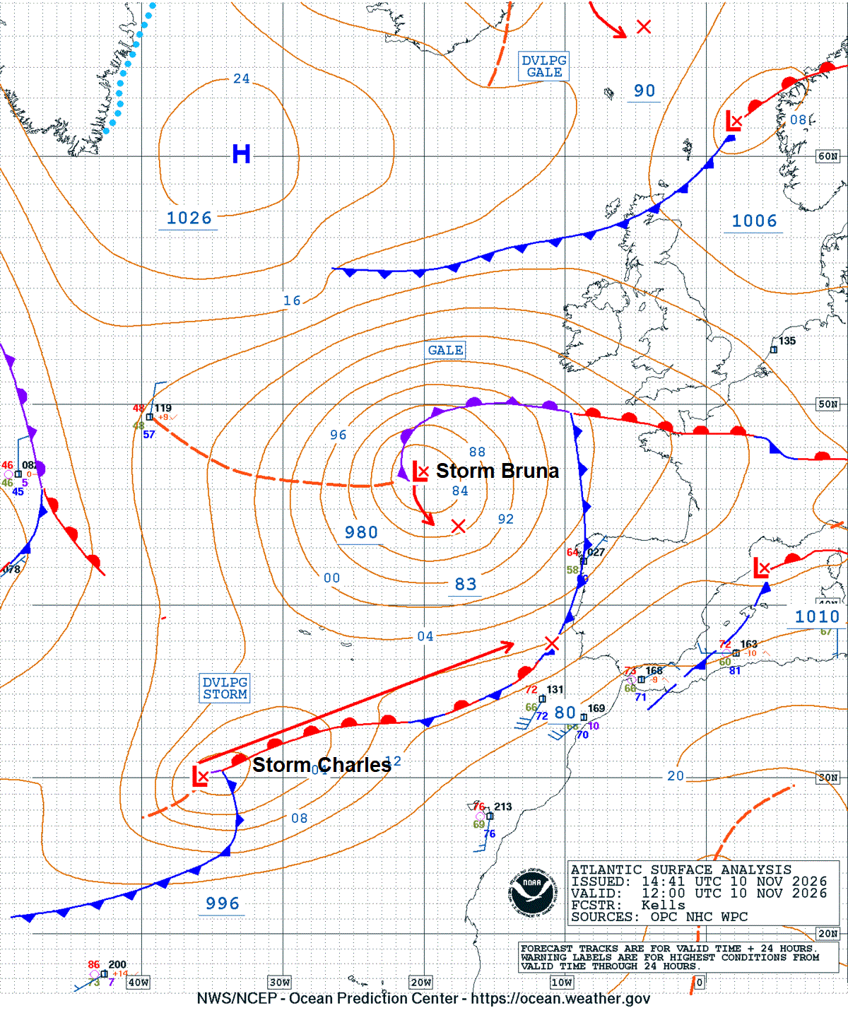
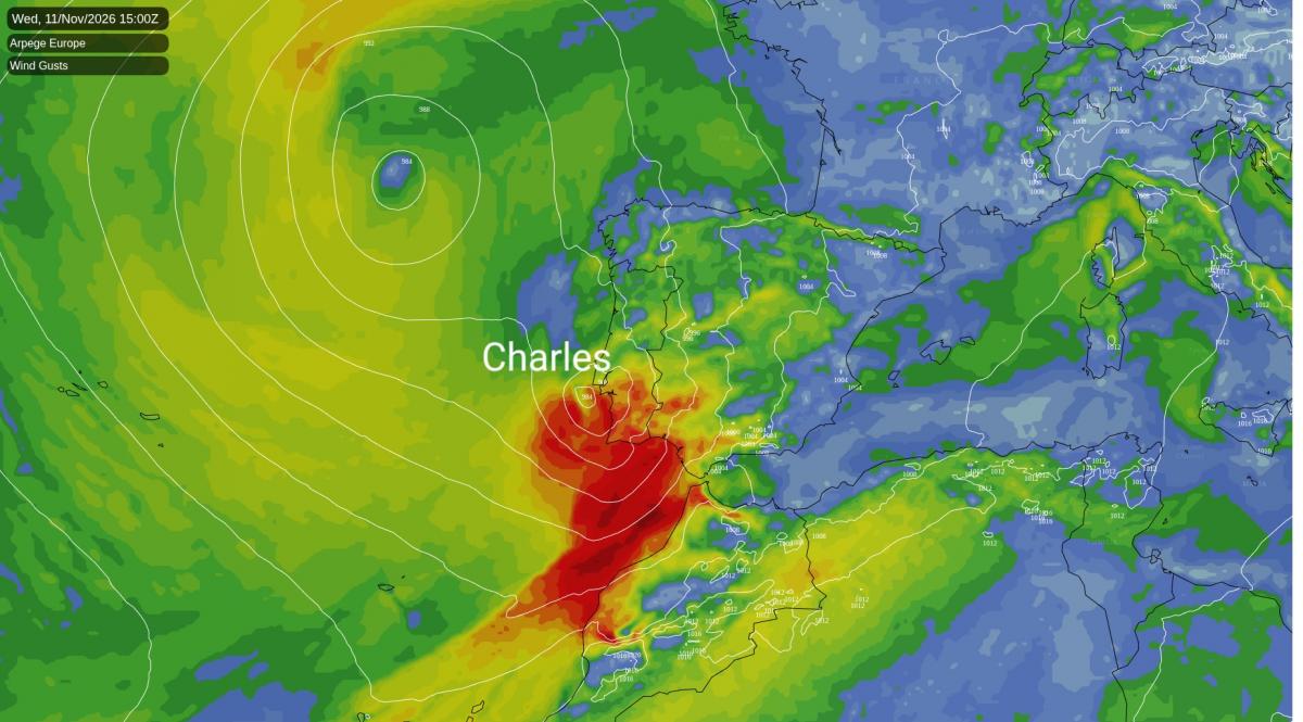
However, Storm Charles, the third named storm of the SW Europe 2026/2027 storm season, which formed over the subtropical North Atlantic, is expected to be a high-impact storm. The deepening low is expected to be over North Atlantic waters north of Madeira around midnight tonight before tracking northeast towards Portugal - making landfall over the country, perhaps near Lisbon, late afternoon or early evening on Wednesday, as an unusually deep low for this far south.
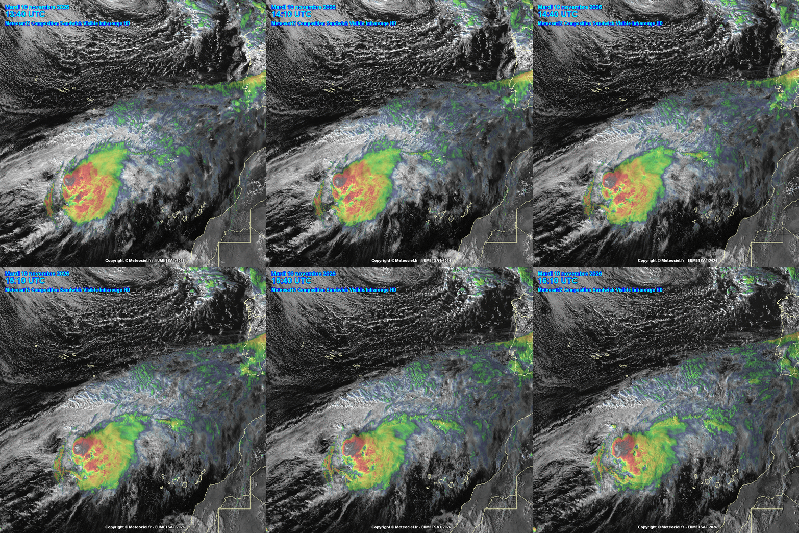
Charles will draw in a warm, very humid air mass from tropical latitudes, resulting in widespread rainfall, which could be heavy or very heavy and persistent in the southern and western halves of the Peninsula, especially in areas with orographic elevation.
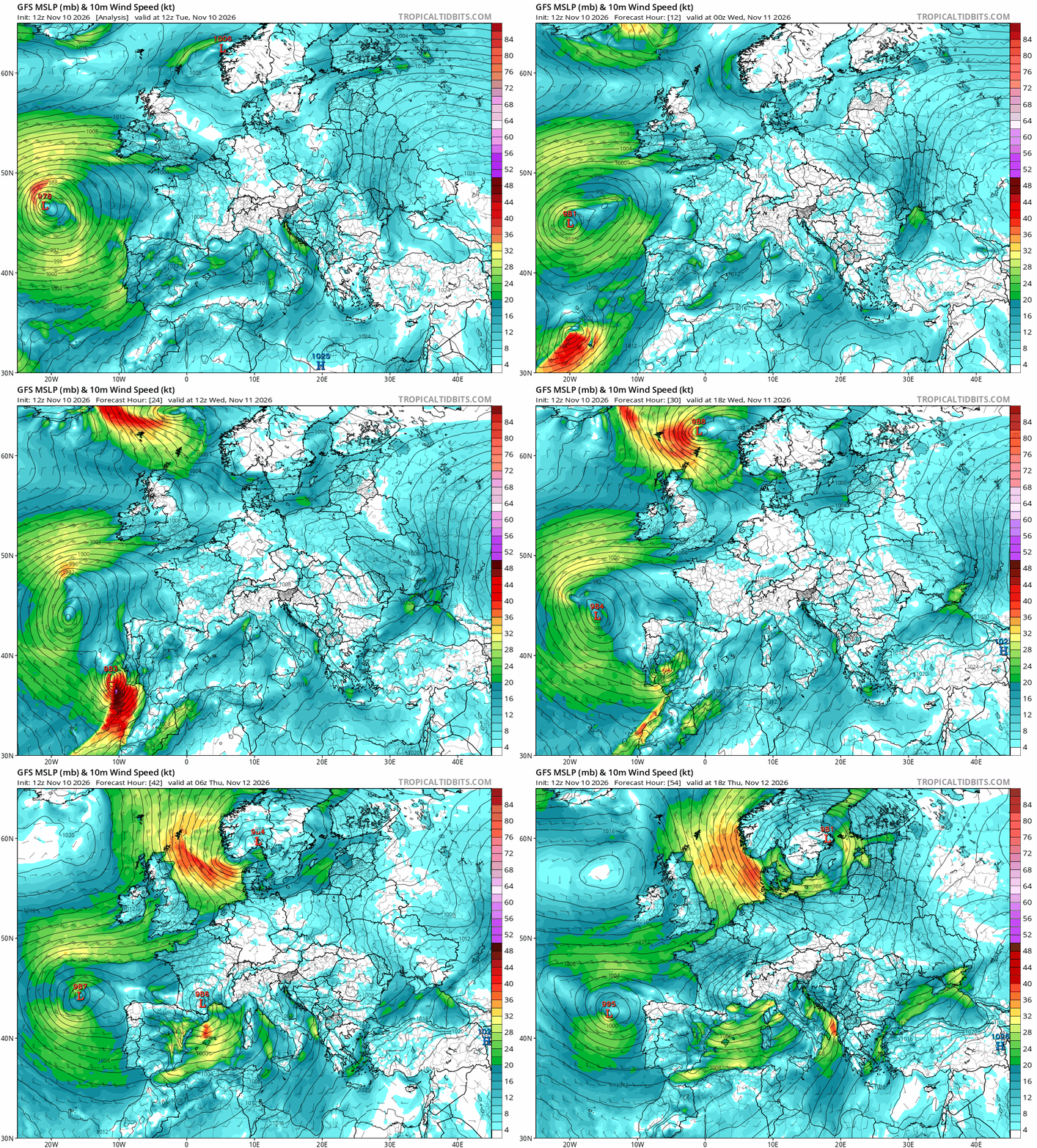
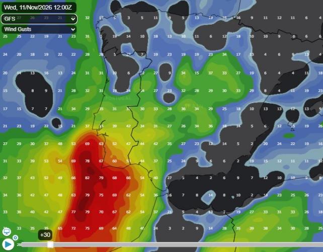
Furthermore, southerly and westerly winds will strengthen as the storm approaches and continues to deepen, leading to significant rough seas and very strong gusts across large areas of the Iberian Peninsula. At the moment the forecast models point to gusts of around 100 to 120 km/h (62-75mph), while in more exposed locations, such as the coastal strip of western Iberia and mountain ranges, they could reach 140 km/h (87mph). There is a possibility of even stronger gusts, if a sting jet forms, like it did with Storm Kristin - which caused millions of euros worth of damage earlier this year. Portugal’s weather authority IPMA has suggested that there are some ingredients that indicate that (sting jet) is a possibility. The phenomenon is caused by very strong, descending winds that hit the surface with destructive force.
The southern half of mainland Portugal and the Madeira archipelago are under severe red weather warnings due to the dual impact of Storm Charles and Storm Bruna. In response to the extreme risk, the Portuguese government has declared a nationwide state of alert, ordering all schools and non-essential public services to close on Wednesday, 11 November.
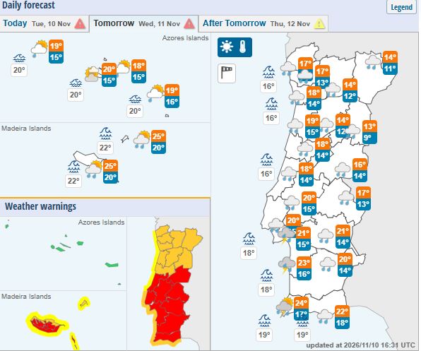
For Madeira (High Peaks & South Coast) the Red alert is active from 9:00 pm Tuesday until 6:00 am Wednesday, for gusts up to 130 km/h and waves up to 4.5 metres.
For mainland Portugal: Beja, Faro, and Setúbal districts - the Red wind warnings run from 9:00 am to 9:00 pm on Wednesday. Lisbon, Évora, Leiria, Portalegre, and Santarém districts - Red wind warnings run from 12:00 pm (noon) to 9:00 pm on Wednesday.
The Spanish Meteorological Agency AEMET has placed parts of western and central Spain on maximum alert with a Red Warning for life-threatening rainfall, flash floods, and severe structural risks. An evacuation has already been ordered in Piedralaves (Ávila) due to localized dam failure risks. Northern Cáceres (Extremadura) is forecast up to 120 mm of rain in under 12 hours. Southern Ávila (Castilla y León) is also forecast up to 120 mm of rain in under 12 hours, with intense bursts exceeding 30 mm in a single hour.
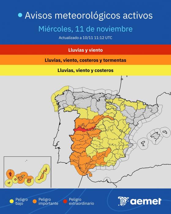
Widespread Amber and yellow alerts cover vast sections of Spain. The Central System & Western Andalusia (Cádiz, Huelva) are forecast total rainfall accumulations between 100 mm to 300 mm across the multi-day storm episode. Galicia & Western Coastlines will experience rough Atlantic seas with waves swelling to 5 to 6 metres. The Canary Islands will experience a significant increase in wind speed, reaching gusts of 130 km/h in La Palma and 100-120 km/h in the mountains.
The storm is forecast to push further east on Thursday across the Alps and the northern Mediterranean areas, threatening Italy (especially Tuscany) and Croatia with extreme downpours,
Further north over NW Europe, a more benign story with the weather. Rain spreading north tonight over southern England and Wales easing through Wednesday morning, with colder and brighter conditions in the north spreading south across all parts of the UK on Thursday, with the rest of the week dry, sunny and cold - as high pressure builds in from the northwest, with risk of widespread overnight frost.
Loading recent activity...