For southeastern Britain, there will be a dramatic change for the rest of the working week. No longer a heatwave after Tuesday as a different airmass from the northwest brings cooler and fresher conditions right down through England. Monday’s top temperature was 33.5C at Wisley. Temperatures will drop from the high 20sC and around 30C on Tuesday, then down to mid then low 20sC for midweek. This will be welcome relief to some who might be feeling drained by the ongoing heat and more recently higher humidity.
However, there is little sign of rain for many drought-hit areas. Northern Ireland and northern Britain will be in the high teens with blustery winds and showery rain.
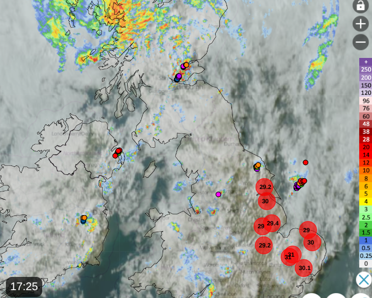
Netweather Radar at 17:25 Tuesday with top temperatures and lightning strikes
Suffolk Fire & Rescue have issued a plea “Please do not visit Dunwich Heath” as people have entered restricted locations or become lost.
“While the incident remains stable, the danger is far from over. Firefighters are still dealing with hotspots across the site every day. What may look like 'safe', burnt ground can be hiding temperatures in excess of 60°C at the surface, with temperatures significantly higher just a few inches below ground.
Underground tree roots, animal burrows and scorched earth continue to smoulder beneath the surface, creating hidden hazards that are not always visible from above.”
The landscape has changed dramatically as a result of the fire, and gusty winds are forecast today and on Wednesday. The outlook remains dry.
In other parts of the UK there could be some heavy and even thundery downpours. Low pressure is over the UK with a cooler, unstable flow from the northwest. There are thunderstorm warnings for Northern Ireland on Tuesday, and eastern Scotland and then another warning for Grampian on Wednesday. It also looks windy on Wednesday for some parts around this low pressure. This will be quite a change for those who’ve got used to the hot, sunny weather under a high pressure.
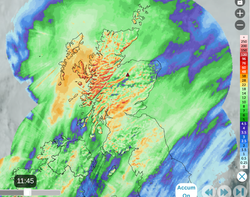
Accumulated rainfall over 24 hours into Tuesday morning Netweather Radar
Northern parts of the UK have seen rain at times, with heavy downpours in the far northwest. This rain is welcome, especially in the fire-affected area in Cairngorm National Park
“A small area of Glenmore reignited and was dealt with despite having appeared and believed to be out two weeks ago. SFRS [Scottish Fire & Rescue] still has six fire engines and crews working on the deep-seated fires.” Nethy Bridge Village Community Council
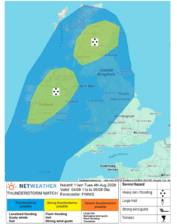
Tuesday “Scattered thunderstorms are likely to develop…and track NE across Ireland, N. Ireland, Scotland and N. England. Fairly strong deep-layer shear may organise cells into line segments - primary risk will be torrential downpours leading to flash-flooding, hail and gusty winds may also occur. Scattered heavy showers are possible further south across England and Wales, with isolated lightning possible.” Convective forecast
For Northern Ireland today “Heavy showers and thunderstorms bringing some disruption to transport and outdoor events”. There will be heavy showers in other parts of the UK but these yellow-warned areas will see slow-moving downpours which could cause impacts as they dump more rain in one spot. There will be gusty winds, and hail is possible.
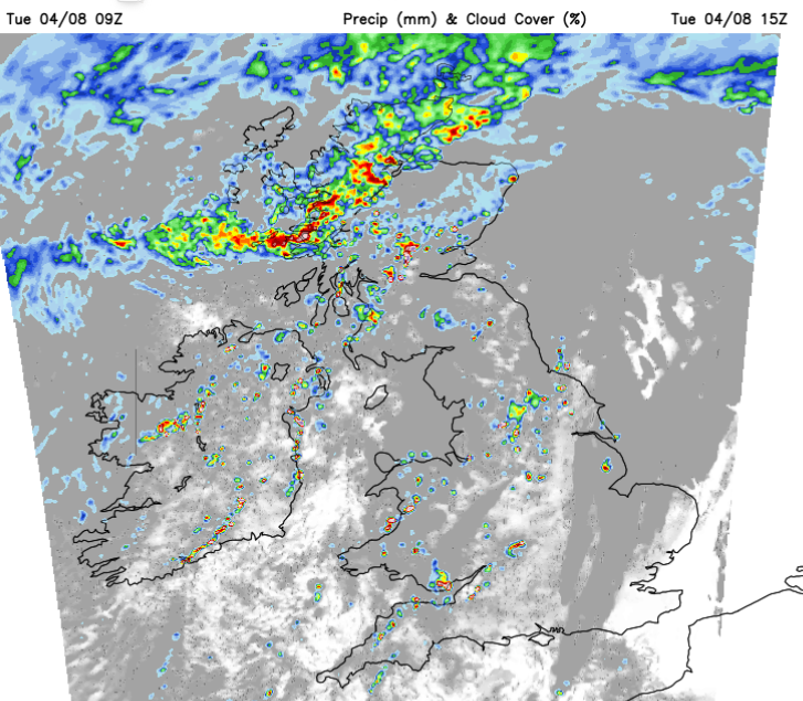
For central and eastern Scotland, the heavy showers could bring 30 to 40mm of rain with large puddles and the possibility of localised flooding ready for the evening rush hour.
Showers will rotate around a low pressure over Wales, the Peak District towards the North Yorkshire Moors. Even a scattering from SW England into the Midlands although many areas will stay dry.
There will still be bright or sunny spells and eastern England into the southeast will have a hot and humid feeling day.
Tonight
The Northern Isles will be in a brisk easterly wind with frontal rain this evening and overnight as the low centre moves over mainland Scotland. North and East Yorkshire could see further heavy showers tonight, as well as through southern Scotland, clearing from SE Scotland early on Wednesday
It will be one more warm night for eastern England and the Home Counties.
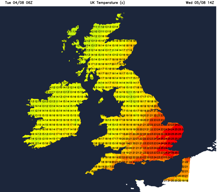
By Wednesday morning everything will be rotating around the low centre. There will be calm conditions over mainland Scotland but a cool northerly wind for the Islands.
This flow will push heavy showers along the west coast down into Northern Ireland with a scattering of showers over northern Britain from the west. Further east there will be more sunny spells but this higher risk of heavy and thundery showers for NE Scotland.
Met Office “These will have the potential to give 20-30mm of rain in 1-2 hours and perhaps 50mm in a few places over 3-6 hours.”
Southeast Scotland will also see heavy showers. There will be a scattering of showers for Wales, clusters over the Lake District and later more of NW England. Much of southern Britain and East Anglia will remain dry. It will be blustery with a moderate to fresh SW wind across central Britain. Temperatures will be in the high teens and low to mid 20s Celsius.
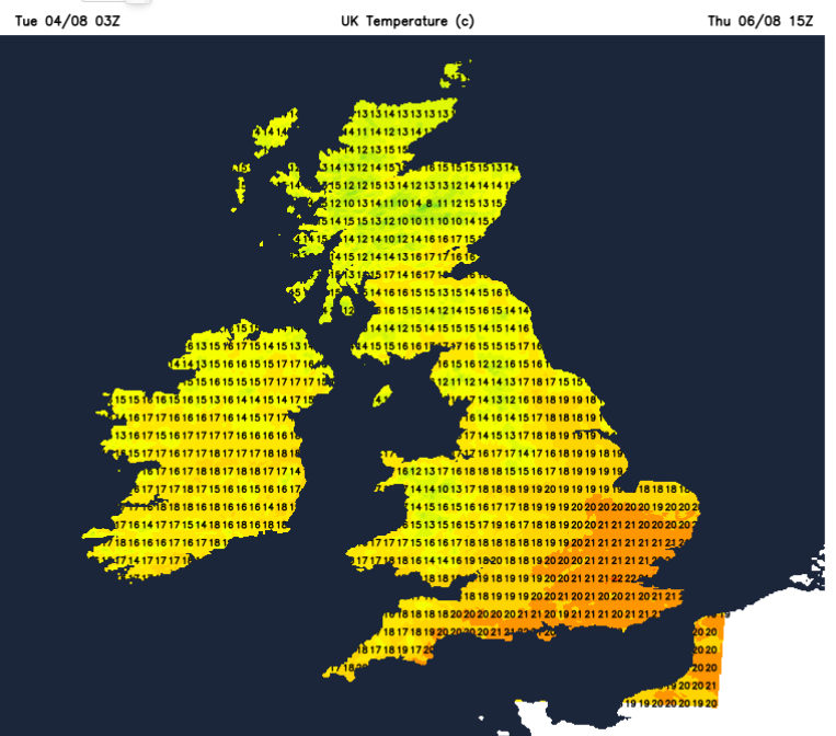
The low pressure will begin to pull away over the North Sea on Thursday. The flow of showers will continue from the northwest with bright spells. There will be more sunshine further south with temperatures around 16 to 23C, so well down on the start of the week. Thursday will become drier and more settled with bright or sunny spells but a cooler feel to the air. The northwesterly wind will add to that fresher feeling. Thursday night will be cool, chilly in places with very light winds, clear skies and still the cooler flow.
By Friday, there will be showery rain for the far northwest but for most of the UK it will be another fresh, bright day with sunny spells and a lot of dry weather.
Loading recent activity...