Following three days with extreme heat warnings during the week and the hottest June day on record in the UK on Friday, with 37.3C recorded at Santon Downham in Suffolk, it has finally turned cooler and fresher from the west across all parts for Sunday.
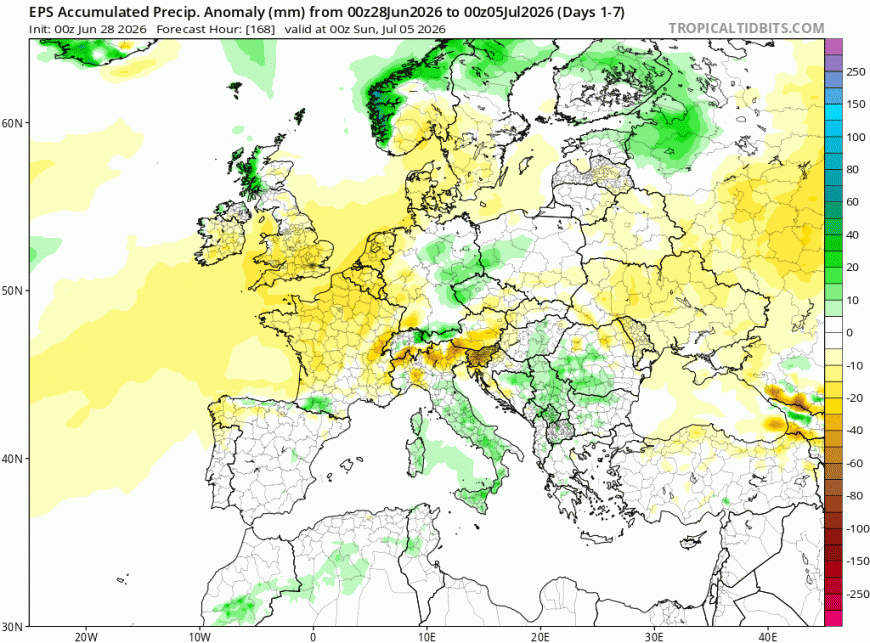
The week ahead is looking much cooler and fresher than this past week, as the extreme heat that’s affected western Europe is shunted further east across eastern Europe by Atlantic fronts pushing in from the west. A strong westerly jet stream will run across the UK throughout the week, bringing a few areas of low pressure east across northern UK during the week, one on Tuesday and another Wednesday night and perhaps one more on Friday. So there will be some rain, though mostly falling across the north, western Scotland wettest, SE England, Midlands and East Anglia could stay mostly dry.
Rainfall distribution for the next 7 days from 00z EPS, drier towards the south
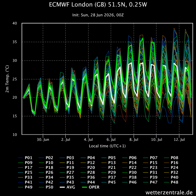
It’s July on Wednesday, we’ve had two record-breaking heatwaves in May and June, so will July see another extreme heatwave? It’s still too early to say with confidence, but there area signs that we could see heat return to the south at least during the week commencing Monday 6th July, as the jet stream shifts to the north of the UK, allowing an area of high pressure to the west of France towards the Azores to extend northeast across southern UK. The 00z ECMWF ensembles for London do suggest a corresponding rise in temperatures that week back towards or into the low 30s, with some ensemble members creeping into the mid-30s Celsius. Need a few more days at least until it becomes more certain that heat may return.
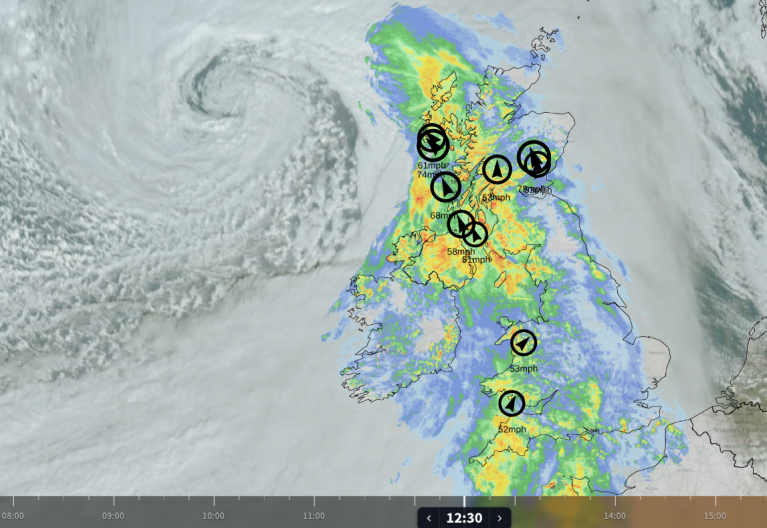
Back to today, a weak cold front is clearing eastern England at lunchtime, just a band of cloudier skies and no rain, following on behind sunny spells and patchy cloud but dry for many, though some scattered blustery showers possible across the western Scotland, Northern Ireland and northern England. Much cooler and fresher in a brisk southwesterly breeze. Temperatures reaching 25-27C across eastern England, 19-23C further west.
A mostly dry start to the week on Monday, with sunny spells, though cloud will build up through the day, with a few scattered showers possible across the west.
Outbreaks of rain spreading east Monday night ahead of low pressure approaching NW Ireland, followed by sunshine and showers on Tuesday as low pressure move east across the north, showers heavy across the north, with thunderstorms possible here too. Far south of England could stay mostly dry and sunny.
Precipitation and pressure for the week ahead
A brief ridge of high pressure builds in Wednesday morning following Tuesday’s low clearing east from the north, so a sunny and dry day for much of England and Wales, with lighter winds, but wind and rain look to spread in across Scotland and N. Ireland late afternoon into the evening, rain perhaps reaching northern England and Wales too Wednesday night.
Fairly deep low crosses Scotland Wednesday night / Thursday morning then as it clears out into the North Sea, another brief ridge of high pressure builds in, with a cool northwesterly flow across the UK, bringing some showers in the north, but southern areas could stay dry and sunny.
Friday may see another fairly deep low pass over or to the north of Scotland at some point, could bring gales here for a time around coasts and over hills along with a spell of heavy rain across the country and perhaps further south across N. Ireland and northern England too. Southern areas mostly dry.
00z EPS shows extreme heat transfers to Eastern Europe next few days but may start to rebuild over Iberia then France in early July, with southern UK perhaps tapping into this heat too
Then next weekend may start to see high pressure system to the southwest of the UK start to extend northeast across the UK, though uncertainty how quickly this may happen, always a risk of further lows with weather systems bringing rain or showers moving in off the Atlantic across the north next weekend and into the following week too. But if high pressure does start to build from the southwest in a more sustained way, then we will start to see temperatures on the rise across the south from next weekend. Possibly another heatwave developing the following week as high pressure builds in strongly over the UK, but as mentioned already, not certainty on this yet. So watch this space.
Loading recent activity...