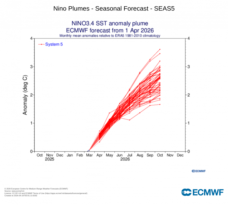
Recently, leading climate models from the ECMWF and NOAA indicate a 20–25% chance of a "Super" El Nino event developing by late 2026, with an 80% chance of a "strong" event. But we could see a strong El Nino develop as early as this summer.
The US Climate Prediction Centre update 5 days ago states:
A transition from La Niña to ENSO-neutral is expected in the next month, with ENSO-neutral favored through May-July 2026 (55% chance). In June-August 2026, El Niño is likely to emerge (62% chance) and persist through at least the end of 2026.
While the most direct impacts of El Niño are felt in the Pacific, North and South America, it influences Europe indirectly by shifting the North Atlantic jet stream and altering pressure patterns.
El Niño is a natural phenomenon in which circulation between the ocean and the atmosphere in the tropical Pacific changes – every few years it swings into the warm El Niño phase or the cold La Niña phase.

The strongest El Niño episodes have almost always contributed to record global temperatures, extreme heat, droughts and floods in various parts of the world.
El Niño occurs when warm water pools up in the eastern Pacific Ocean, around the equator. Once the temperatures reach 0.5 degrees Celsius (0.9 F) warmer than normal in the sea surface, an El Niño has formed.
A "Super El Niño" is typically defined by sea surface temperature (SST) anomalies in the central-east Pacific rising more than 2.0C to 2.5C above the long-term average. As of April 2026, climate models from NOAA and ECMWF indicate a significant shift from the recent La Niña into a potentially record-breaking El Niño event developing later this year.
The European ECMWF model is the most bullish – indicating that conditions in the tropical Pacific will start to change as early as spring and intensify significantly over the summer. According to the ECMWF the probabilities of a Super El Niño developing are 20 to 25 percent, as strong El Nino 80 percent, a moderate El Niño 98 percent.
Simulations by the ECMWF model even suggest a particularly rapid development, possibly unprecedented since the beginning of modern observations. This dynamic is explained by the presence of abnormally warm waters at depth in the western Pacific, combined with very active westerly winds that promote their upwelling to the surface. In an ocean that is already generally warm, this cumulative effect could lead to an exceptional event.
An El Niño usually brings higher global temperatures, as the excess heat in the Pacific Ocean eventually enters the atmosphere. This causes warmer global temperatures. However, the rise in temperatures often has a lag time of a few months, so if a strong El Niño does emerge later this year, 2027 could become one of the hottest years on record.
In the context of global warming, an El Niño event today would no longer produce the same effects as it did 10 or 20 years ago. Ocean temperatures are already at record highs, exceeding those of the same time last year, which increases the risk of a runaway climate system. In this already warming context, such an event could cause lasting disruption to global climate balances, with effects likely to extend beyond a few months and influence several seasons.
This potential Super El Nino event could exacerbate the rise in global temperatures, with a possible peak in 2027 (some scenarios predict a 2027 temperature increase of 1.7°C above pre-industrial levels), while also creating stark contrasts: intense rainfall and flooding in some regions, severe droughts in others. Cyclonic activity could be intensified in the Pacific, but more limited in the Atlantic. In Europe, the general trend is towards warmer than normal conditions, sometimes accompanied by increased instability (storms). However, these projections should be interpreted with caution at this stage, as the reliability of the models remains limited several months before the event.
Recent history includes some Super El Nino events, including the peak of 2.6 °C in 2015-2016, or that of 2023-2024, which just crossed the threshold of 2.0 °C.
In summer, El Niño often causes extreme, widespread heatwaves and drier conditions across Europe. Spain, in particular, may face increased risks of intense extreme heat, with potential for long-lasting high temperatures. For the UK and Ireland, the impacts of El Nino are less clear-cut. Recent years with summers with a developing El Nino: 1997; 2015 and 2023 featured a mixed bag of weather, though all 3 summers feature some hot weather, notably August 1997 and June 2023. There were years prior with summers of a strong El Nino developing, but global warming has made using this years as analogs difficult - as they were in a different climate. Latest seasonal output from NWP models suggests overall warmer than average across Europe this summer, drier in the north of Europe, average to wetter in the south.
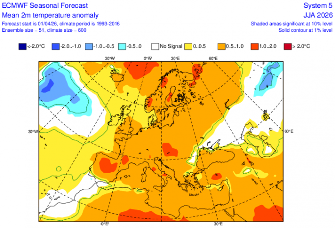
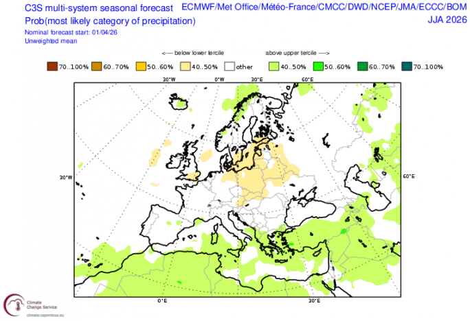
So if El Nino does develop by the summer, we could have impacts on weather patterns. But with a Super El Nino unlikely to develop until later in the year, so its impacts on weather patterns more likely to be seen during the winter, while the potential for high temperatures, particularly in summer, may not occur until 2027, given the lag of the atmosphere responding to the additional warming of El Nino in the Pacific.
However, the impact of El Nino is generally much weaker than the average impact of climate change, which is characterised by a rising trend in temperatures, particularly pronounced in Europe. Europe has experienced unprecedented summer heat in recent years, such as 2021 and 2022 during La Nina, which in the past was associated with cooler global temperatures, so the effects of El Niño may be barely perceptible against general background warming of the planet. Though summer 2024 saw unprecedented heat in Europe on the back of the strong El Nino of 2023-24.
Loading recent activity...