At the end of October, Hurricane Melissa caused considerable damage especially in Haiti and Jamaica, and currently stands as the strongest tropical cyclone of 2025 so far, and the joint third most intense Atlantic hurricane on record, with a peak low pressure reading of around 892 millibars. There has been widespread destruction to buildings, and so far it is estimated that 30 people were killed in Haiti and 22 in Jamaica, with many people without water and without homes, as roofs have widely caved in. Relief efforts are ongoing, but it will take a long time to clear the wreckage and restore these regions to something resembling normality.
A major factor behind Melissa’s destructiveness is considered to be that Melissa never underwent an eyewall replacement cycle, where some of the outer rain belts of the cyclone turn into a ring of thunderstorms in the outer eyewall, which can contribute to the death of the inner eyewall and shorten the length of time during which the cyclone is intense and destructive, though sometimes the outer eyewall can replace the inner eyewall and cause the cyclone to intensify again. This did not happen with Hurricane Melissa, which allowed it to remain continuously intense for almost a full week.
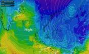
Hurricane Melissa has now transitioned into a hurricane force extratropical depression in the western North Atlantic. This depression is expected to come close to north-western Britain during the coming week, but the current sets of forecast model runs suggest that it will probably not have a major impact and will probably get drowned out by various other extratropical lows that will affect Britain during the coming ten days or so.

Britain’s weather looks set to be mild and unsettled during the next ten days, with mainly south-westerly winds and frequent bands of rain interspersed with some brighter, showery weather, and strong winds at times. It looks set to be wet for most of us, particularly in the west, although north-east Scotland and parts of eastern England may end up with near or slightly below average rainfall during the next ten days. There are still signs that the weather will turn more settled around mid-November, though it may well not result in a spell of persistent high pressure, more like a mix of low and high pressure spells instead of having low pressure dominant all the time.
Some recent runs of the American GFS model (Global Forecast System) have been showing spells of easterly winds in the extended timeframe, 10 to 16 days out. “Easterly” snowfalls have been known in November, including a notable one around 21-22 November 1993 as well as the ones at the end of November 2010, but most of the time easterlies in November are not quite cold enough to give widespread snowfall, as central and eastern Europe are still in the process of cooling down at this time of year. One fairly recent example of a November easterly that failed to deliver any snow for most lowland areas was in 2018, although it still turned colder than average for a time.
In any case, the forecast models are typically unreliable at more than 10 days out, although from time to time they do pick up on trends that turn out to be close to the actual outcome. Other possibilities that have been showing up on the European ECMWF model in the 10-16 day ahead timeframe include a high developing over the British Isles, or a mid-Atlantic high, which would make us more prone to northerly winds. All of these scenarios point towards it becoming rather less mild as well as less unsettled towards mid-November, with some colder spells, possibly cold enough for frosts at times, but not necessarily cold enough for widespread snow.

The Met Office are yet to officially update the statistics for October 2025, and I will come back to how October went in the next article, but provisional statistics from Dan Harris’s site at Roost Weather, which is based on Met Office observing sites, suggests that, although sunshine totals did generally pick up during the last third of October, sunshine ended up well below normal in most parts of the country. It looks to have been a particularly dull month in the west, with sites in Northern Ireland only getting around 30 hours of sunshine, when normally in October these areas see close to 100 hours. In contrast, rainfall totals for October look to have been generally unremarkable, as the shortage of sunshine came partly from spells of anticyclonic gloom, particularly around midmonth, though it was a wet month in parts of Northern Ireland.
The dullness of October has been a stark contrast to previous months, with spring 2025 having just surpassed 2020 as the sunniest spring on record for the UK as a whole, and June through to September having had near or above average sunshine in most regions with just limited exceptions.
Hurricane Melissa Satellite image (top) courtesy of Eumetsat.
Loading recent activity...