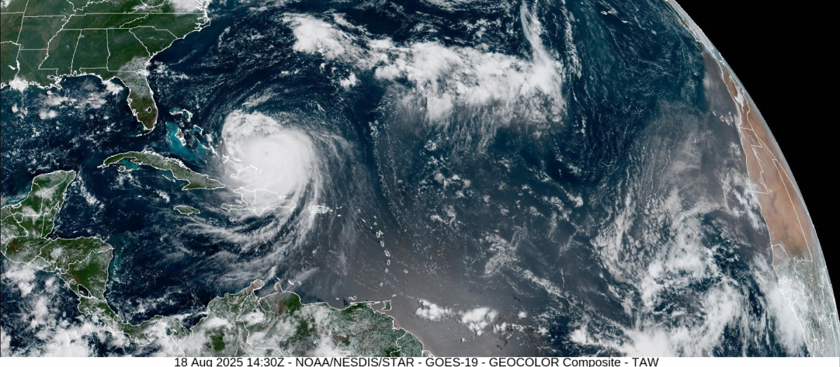
Hurricane Erin is developing into a huge, powerful cyclone in the western Atlantic Ocean. At the weekend, it was a compact, intense cyclone which reached Category 5 status for a time but has not made landfall. Coastal impacts are expected from the large swell with erosion and flooding, but also life-threatening rip currents as this monster hurricane churns northwards this week.
“Erin is a category 4 hurricane on the Saffir-Simpson Hurricane Wind Scale. Some additional strengthening is expected today [Monday 18th]. Erin will remain a dangerous major hurricane through the middle of this week.” NHC 12z Mon 18th
The Atlantic season has produced four tropical storms and one hurricane so far. Tropical Storm Andrea doesn’t need a mention. Tropical Storm Barry reached eastern Mexico at the end of June, with heavy rain and flooding. Tropical Storm Chantal in early July made landfall over South Carolina, bringing heavy rain to the coastal plains of the Carolinas. Tropical Storm Dexter would also have gone unnoticed well out in the Atlantic but it did end up west of the UK. It brought tropical energy and moisture, with some welcome rain reaching the far NW of the UK in early August. It also helped steer heatwave hot air from southern Europe up to Britain and Ireland.
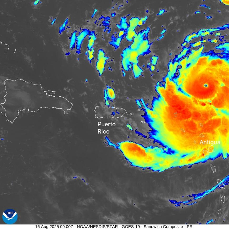
Erin is the first hurricane of the 2025 season. At the weekend, the heavy rain from the outer bands caused flooding in Puerto Rico as strong winds damaged some trees. The power supply in Puerto Rico is not known for its reliability, and there were power outages as the storm passed by to the northeast. The main impacts were from falling trees, pulling down electricity cables, leading to danger from live wires being in flood waters. There was also heavy rain for the northern Leeward Islands, the Dominican Republic and the Virgin Islands.
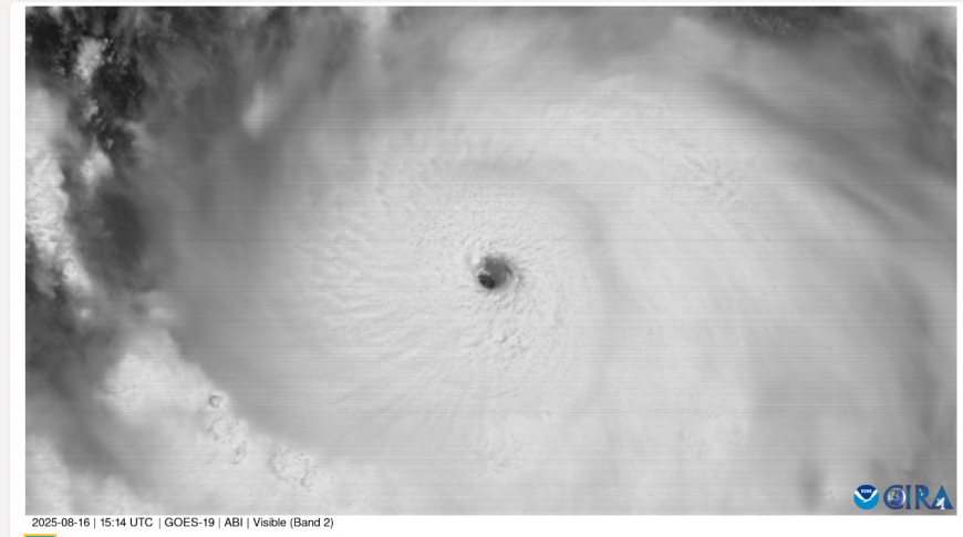
Erin was a Cat1 hurricane at 11am EDT on Friday, then rapidly intensified to a Cat5 (briefly) just over 24 hours later. This was an incredible intensification in terms of speed but also unusual to be in mid-August. The minimum central pressure fell to 915hPa. The change from 75 mph winds to nearly 160mph qualifies it for “Rapid Intensification: An increase in the maximum sustained winds of a tropical cyclone of at least 30 kt (34.5mph) in a 24-hour period.”
What next
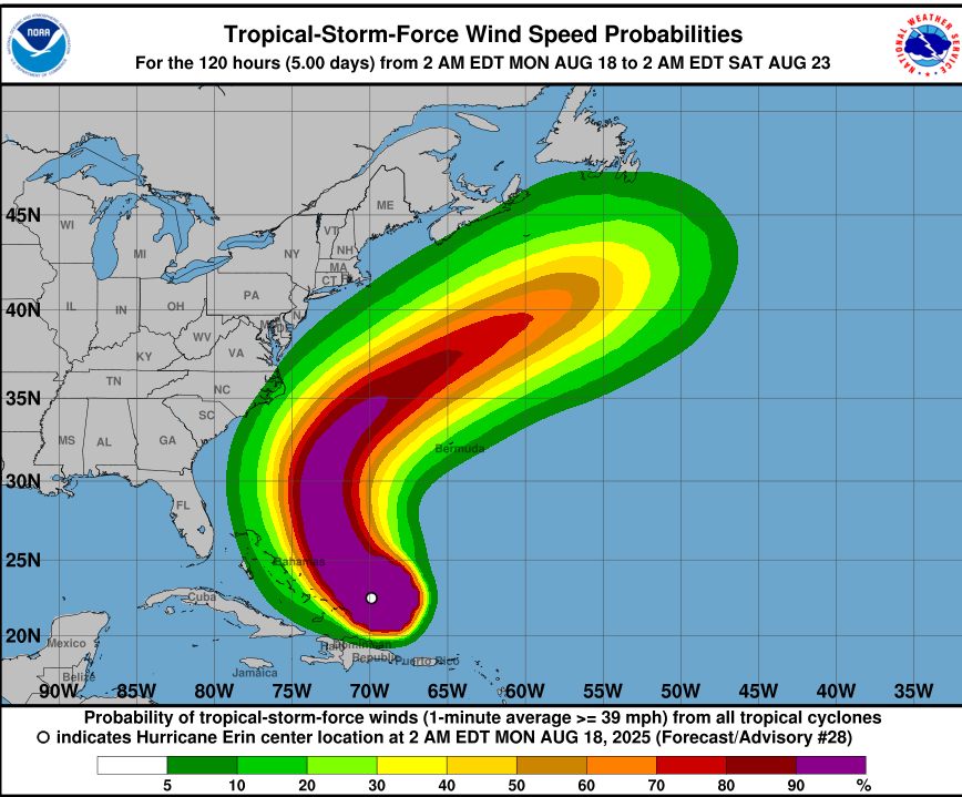
“Erin's outer rainbands are affecting the southeast Bahamas and the Turks and Caicos Islands, and those locations will likely continue to experience tropical storm conditions for several more hours.” 09Z NHC
The main worries for the Bahamas and the east coast of the USA will be life-threatening rip currents and a large swell, which is likely to cause erosion damage.
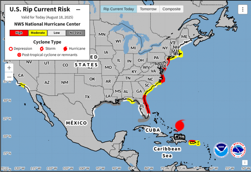
Bahamas Dept. of Meteorology “Mariners should remain in ports until the end of the week as the seas could become extremely rough and dangerous during the swells. Swimmers and beachgoers are strongly urged to remain onshore until conditions improve by the end of the week. Additionally, high surf conditions will result in overtopping waves, sea spray, coastal flooding and minor to moderate coastal erosion, mainly along the eastern Atlantic shorelines.”
On the eastern seaboard, there have been evacuation orders for the Outer Banks (a string of low lying barrier islands off the coast of North Carolina) due to washover fears, where the causeways see flooding and shifting sands build up from large waves. Erin is a powerful hurricane but also becoming a very large one and there could be strong winds for the Outer Banks, Bermuda and exposed parts of the east coast, even if the path of Erin looks to be well out at sea.

The cone which shows the hurricane could be at the western (or eastern edge) for its path northwards
Erin’s expanding wind field will result in rough ocean conditions over much of the western Atlantic. The NHC (National Hurricane Centre) has noted that “the 34- and 50-kt wind speed probabilities beyond 36 hours in the text and graphical products are likely underestimating the risk of those winds occurring. This is because the forecast wind field of Erin is considerably larger than average compared to the wind field used to derive the wind speed probability product.”
Erin is a huge and powerful hurricane. The rapid intensification over the weekend drew attention. As our oceans and the atmosphere continue to warm due to climate change, there will be more incredible hurricanes, but perhaps not staying offshore. Category 5 hurricanes are unusual, but this is the eleventh Category 5 hurricane recorded in the Atlantic since 2016 and it is early in the season for such a powerful storm in this part of the world.
“August 7, 2025 As the 2025 Atlantic Hurricane Season enters its historical peak, atmospheric and oceanic conditions continue to favour an above-normal season” NOAA
For Americans, this season is set against the Trump Administration’s cuts to the National Oceanic and Atmospheric Administration (NOAA), the agency which includes the National Weather Service (NWS) and the NHC. Even as the hurricane stays out at sea, there will be dangerous conditions this week for the island nations already under warnings or watches, but also all along the east coast of the USA, as Bermuda and east coast Canada keep watch. Erin could be south of Nova Scotia on Friday, Newfoundland by Saturday, and then making its way across the Atlantic as an ex-tropical cyclone.
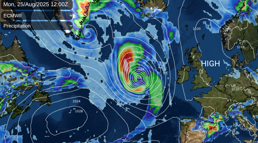
It’s a fair way off with plenty of development to come this week, never mind into next with a journey across an ocean. The GFS and ECM models are showing high pressure over the UK on this run with ex-Erin to the west, which could again draw up very warm air from the south ready for the Bank Holiday. A bit faster, and Erin would throw rain our way.
More discussion and chat on Hurricane Erin in the Netweather community.
Loading recent activity...