This weekend looks hot and sunny for parts of the UK. London should see temperatures rising into the high twenties Celsius, which is heatwave territory, with fine and dry weather. At the other end of the country, temperatures will stay in the mid-teens with more cloud, blustery winds and the threat of occasional rain for Northern Ireland and parts of northern Britain, particularly northwest Scotland. Add to the mix will be the remnants of Dexter. This Tropical Storm is well out to sea, currently in the western Atlantic, south of Nova Scotia and Newfoundland. As it heads eastwards towards northwestern Europe, it will become extra-tropical (no longer a tropical cyclone), but it will bring extra energy and moisture towards northwestern Scotland.
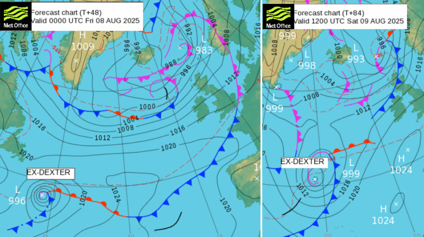
Friday looks blustery for the northern half of the UK, windy for northern Scotland, although nothing like Storm Floris on Monday. There will be strong SW winds for the west coast and islands early on Saturday in Scotland and again a blustery day for the northern half of the UK. Southern counties of England will have only a slight breeze. The remnants of Dexter aren’t likely to bring strong winds, but there could be heavy rain later on Sunday. This looks to extend close to western Ireland and reach northwestern Scotland by Sunday evening. Away from this system, most of the UK remains under the influence of the large high pressure to end the weekend. This means a good deal of sunshine and very warm air and lighter winds for more of Britain to end the weekend.
The heat of the day will linger for eastern England into the evening with temperatures still in the low 20sC. Further north, the blustery winds will disturb any warmth with SW gales through The Minch for Friday night.
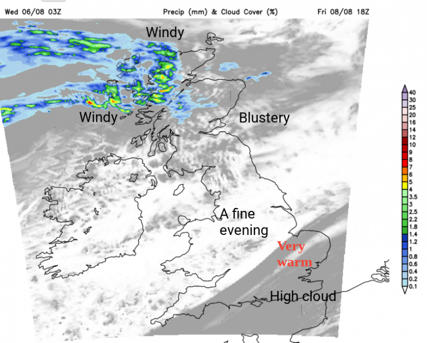
Frontal bands will be close to northern Scotland, bringing more cloud and outbreaks of rain with the windy weather. There will be a strong jet core over the UK by Saturday, which edges northwards by Monday, allowing the high pressure to have more influence. For the weekend, there will be this blustery weather in the north but often fine, settled weather for southern Britain.
For Saturday, a cold front will move from the Western Isles over more of mainland Scotland, perhaps reaching Northern Ireland by the evening. The UKV model has this as a distinct, narrow band which could bring sharp downpours with sudden gusty winds. The day will be blustery anyway in the north but this band will interrupt otherwise bright and fine weather.
Away from this band, there will be a lot of fine, warm weather with temperatures of 21C for Aberdeen and Newcastle, around 25C for Birmingham and Norwich. Temperatures in SE Britain could reach 28C, which is the top threshold value to begin counting the days for a heatwave. The threshold values vary between 25C and 28C with three consecutive days needed.
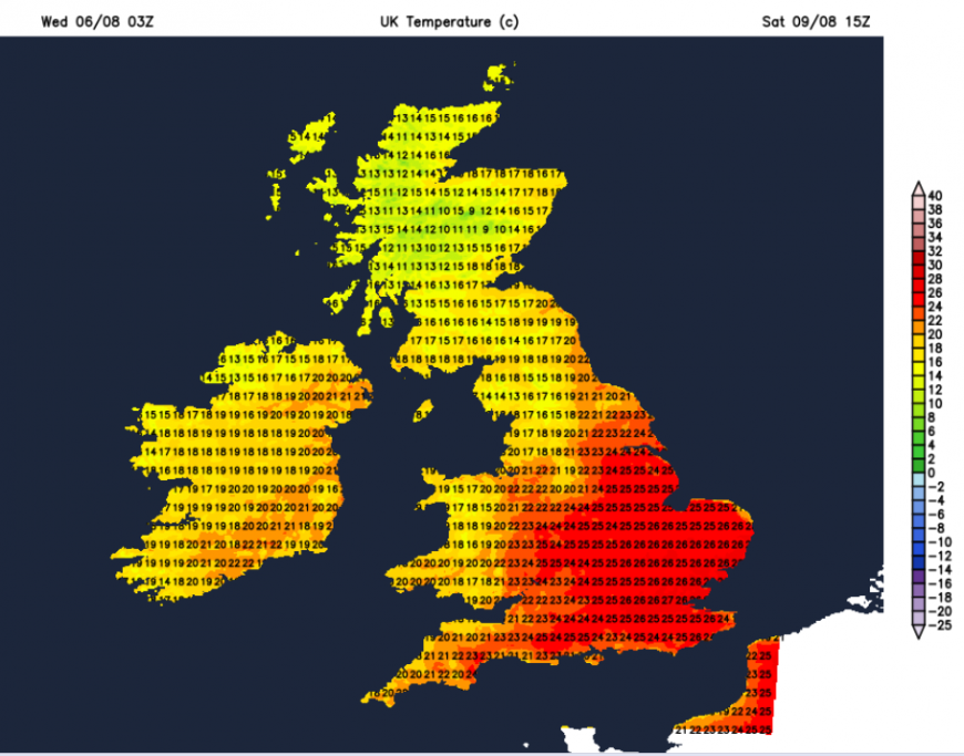
The winds will ease down overnight with clear skies. London will hold onto the warmth as the heat will be stored in the concrete of the city but for more rural spots in Scotland and Wales, the Moors of the SW, it will feel cooler if you are camping this weekend.
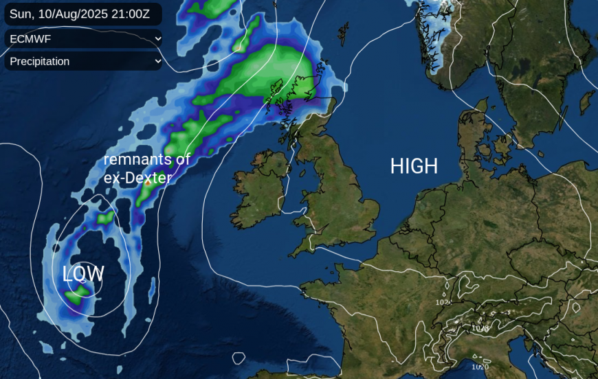
Sunday will be a balance of sunny, fine weather with rising temperatures against the incoming Atlantic system linked to ex-Dexter. This will spill some cloud and rain over western parts, but there has to be some uncertainty at this stage over the detail of where and when the rain will arrive. With its tropical origins, it could turn heavy too.
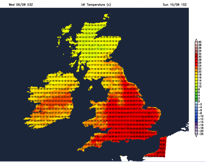
However, much of the UK will see a warm, even hot Sunday with sunshine. Temperatures could be more widely up into the mid/high 20sC even reaching 30 or 31C on Sunday for a few spots. Temperatures in the north could be higher than the UKV chart shows, if the rain and frontal cloud are kept further west for longer. More sunshine means that the temperatures will be higher.
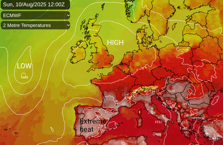
There is plenty of heat for southern Europe already with amber heat warnings for Portugal and Spain as Madrid nears 39C midweek. That heat will edge northwards through France and add to the rising temperatures over the UK into the start of next week. However, it will be the sunshine and high pressure setup which could allow our temperatures to move towards 33C.
Loading recent activity...