Heat for the start of Wimbledon but cloud, rain and flood alerts for parts of Scotland on Monday. One more day of heat in the south but fresher air will arrive, although it remains warm in any sunshine this week.
The contrasts across the British Isles are stark today. In the southeast of Britain, temperatures had already passed 30C by lunchtime with the possibility of 34, even 35C, for heatwave England. Wimbledon is starting a week later than usual, but it is expected to experience its hottest opening day.
With brilliant sunshine and clear blue skies, the continuing heat is accompanied by humidity. This is making it feel close and uncomfortable, especially when trying to get to sleep and Monday night will be sultry.
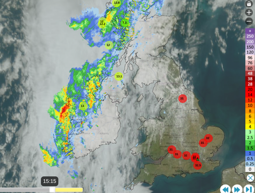
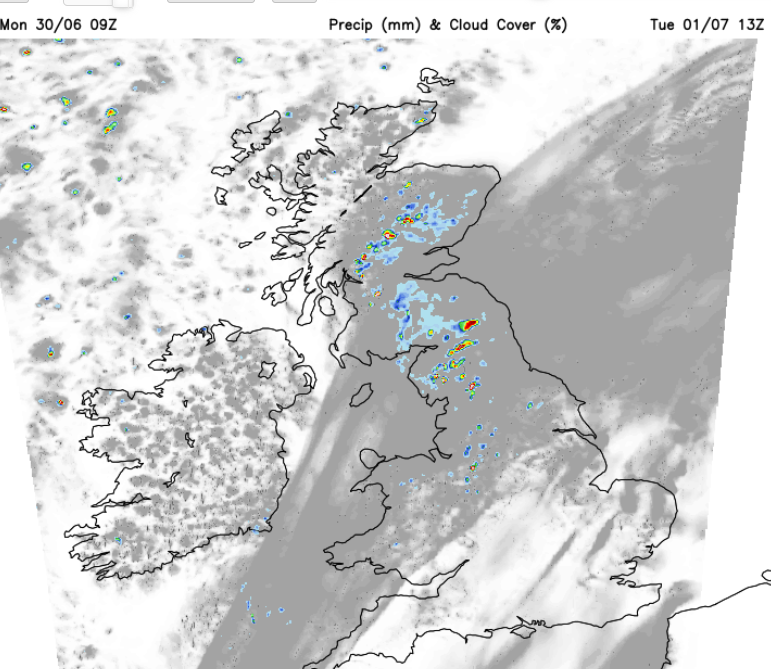
Netweather Radar showing heat over England with temperatures over 31C and frontal rain to the NW with lower temperatures.
Energy companies such as Octopus are offering energy-saving sessions this evening “to keep the grid steady”. In times of heatwave, perhaps as everyone arrives home to cook or have a cooling shower, there will be increased strain on power equipment and systems with the challenge of balancing power supply and demand. The energy companies will be looking to significantly reduce stress on the grid during peak demand periods, such as Monday evening.
In this hot and humid air, there could be isolated surface-based convection with a low likelihood of thunderstorms for inland eastern England. Here, there have been days of heat, and with a slight convergence zone due to a moderate SSE breeze off the North Sea, this would be a summery interruption.
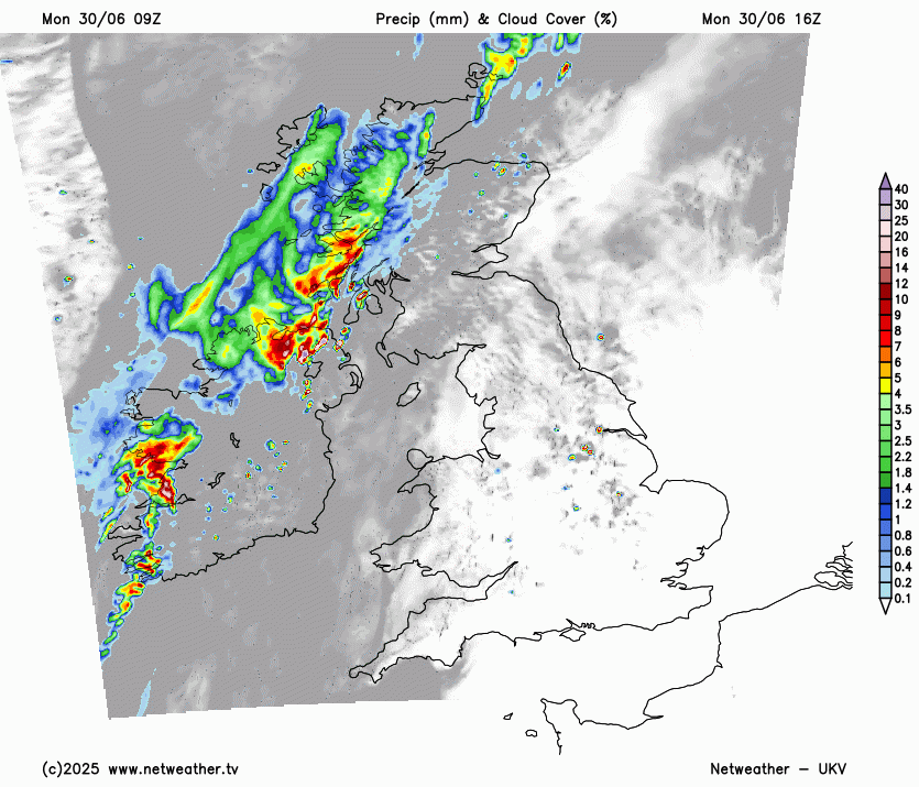
Over Northern Ireland and western Scotland, there is a cold front bringing rain and grey skies. This boundary has the hot and humid air to the southeast and cooler, fresher Atlantic air to the west. Even cloudy Scotland and County Down are managing to feel warm with temperatures into the low 20sC on Monday afternoon. With strong, blustery winds from the southwest, there are large wildfires in Moray with locals and firefighters awaiting any rain.

West coast of Scotland, grey skies and cooler air on Monday 30th June
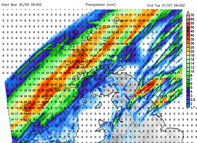
There is going to be some heavy rainfall from this front. Parts of Grampian and Tayside have flood alerts for the change to heavy rain overnight.
“Heavy rainfall may cause flooding from surface water on Monday afternoon and evening. Minor flooding impacts and disruption to travel is possible if the heaviest rain falls in vulnerable areas. Impacts will be isolated, with not all areas being affected.” SEPA Flood
So we have heatwave conditions with health advice at one end of the country, and enough rain in northern Scotland to generate flood alerts at the other.
This rain will move over Northern Ireland, Glasgow and the A9 on Monday evening with intense downpours possible for Belfast and Aberdeen by midnight. Behind the cold front rain, it will feel cooler and fresher with overnight temperatures falling into single figures.
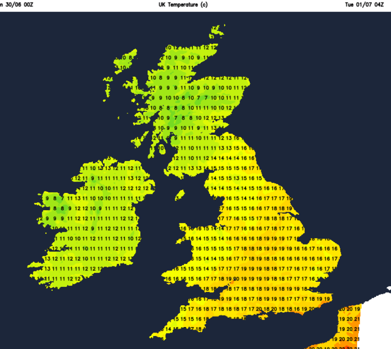
No such luck for SE Britain, where the heat and humidity remain on a sticky, close night.
“A tropical night is defined as a night when the temperature does not fall below 20°C.” This looks possible for a few spots on Monday night before a change from the northwest. These are rare but do occur in heatwaves and “are becoming less rare in the UK”.
“Tropical nights can have a profound impact on human health. The body relies on cooler nighttime temperatures to regulate core temperature and recover from daytime heat.”
The temperatures will soon leap up on Tuesday for southeastern Britain, climbing through the 20sC into the 30sC once more. For northern Britain and Northern Ireland, it will feel fresher but still warm in any sheltered sunshine. The breeze will be from the northwest and will make a difference. There will be remnant cloud cover and a scattering of showers along the waving cold front. This will bring grey skies over Wales and inland northern Britain with a damp flow off the North Sea. This low cloud will continue to flow in off the sea, on Tuesday reaching down to the Yorkshire coast and then by Wednesday morning down to the Thames. This will be a change from bright sunshine. There could be some active showers by Wednesday morning with a cluster along the coast of NE England and another line over Kent or Essex as the last of the humid heat clears.
The UK is then left in a west to northwesterly flow with warm sunshine but a scattering of showers over northern Scotland. High pressure does build in from the southwest by Thursday, with more fine, sunny and warm weather for most.
Friday looks very warm and sunny for much of SE Britain but there will be a weather front bringing cloud and outbreaks of rain for the north and west. This will affect the temperatures but eastern regions could still see warm sunshine in the blustery SW wind.
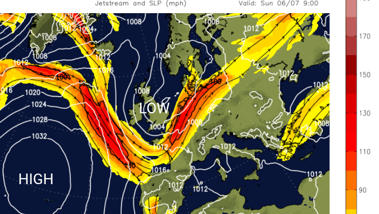
As the jet stream dives southwards, the high pressure slips away. It looks like it will be low pressure dominating the weather next weekend, with a cooler feel to the air and outbreaks of rain, especially in the west.
Loading recent activity...