Changeable for the rest of this week, with some rain for many, perhaps thunderstorms Wednesday in the far southeast. Turning drier and hotter in the south by Sunday, perhaps into the low 30s deg C.
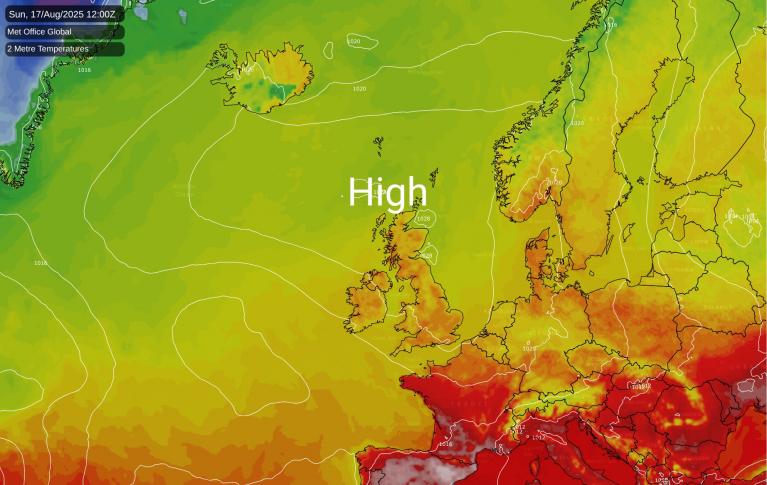
After a changeable and windy week, with spells of sunshine or cloudier periods with some rain for some - as weather fronts move through, high pressure looks to return across southern areas this weekend, with a return of heat from Sunday. Temperatures on Sunday could reach 30-31C towards SE England and East Anglia, perhaps hotter on Monday with temperatures forecast by some models to reach 33-35C.
The change will come about as the jet stream, which is running west to east across the UK this week, shifts north, allowing high pressure to extend northeast from the Azores across western Europe. The ridge of high pressure looks to be anomalously strong too. Geopotential values at 500 hPa will be near record highs for this time of year and a ‘heat dome’ looks to form as the strong ridge traps hot air being pulled north and northeast from NW Africa. Temperatures over western and northern France look to reach 40-41C on Monday, well-above average. Southern UK tapping into some of this heat on Sunday and Monday - before cooler conditions push in from the west by mid-week.
Near record strong 500 hPa geopotential heights (strong upper ridge) building over SW Europe over the weekend
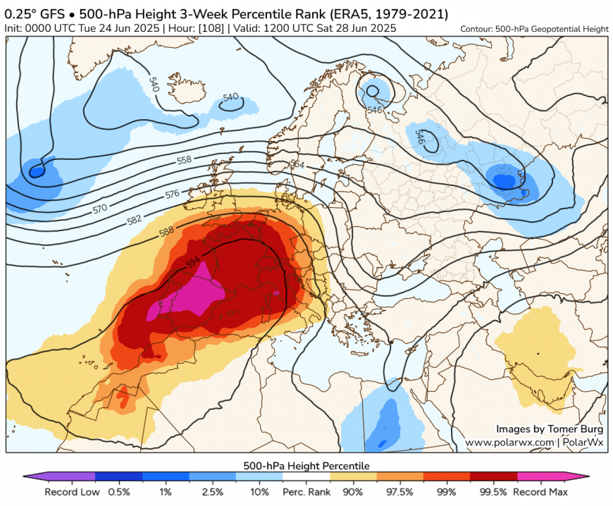
Hot air building under the ridge over mailand Europe looks to spread into southern UK too from Sunday
Before then, the changeable conditions continue for the next few days, with some rain at some point for many, though not much for some, along with some sunny spells too. Most have seen some rain overnight, from a warm front moving east, with cloud lingering and the odd spot of rain this morning, staying rather cloudy and damp across the north along and near a slow-moving cold front, with further patchy rain, but turning drier with some sunny spells in the south.
A cloudy start on Wednesday, before very warm and sunny spells develop across southern and eastern England - where temperatures could reach 25-27C, staying cloudier and cooler in the north and west, with some scattered showers. During the evening, heavy showers and thunderstorms developing over northern France look to move northeast and could affect the far SE of England and eastern East Anglia overnight, with a risk of intense downpours and frequent lightning. Bands of rain, locally heavy, spreading east further north and west.
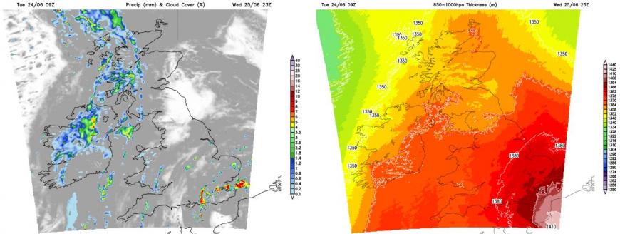
An upper low just off Portugal today will move northeast as a shortwave trough on Wednesday, creating lift and destabilising a warm and humid plume with high theta-w values (wet bulb potential temperatures) briefly glancing SE England. Some uncertainty how far west the risk of thunderstorms could be - but for now, East Sussex, Kent and coastal East Anglia at greatest risk.
Cooler, cloudy and breezy on Thursday, with showery outbreaks of rain spreading east, though turning drier and brighter from the west in the evening.
It will turn drier and more settled across the south from Friday and into the weekend and increasingly warmer too, with temperatures reaching the high 20s degrees C on Friday and Saturday across SE England and East Anglia. Low 20s elsewhere, away from the far west - where it will be cooler.
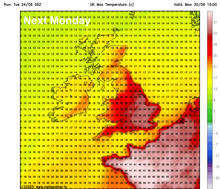
Very hot conditions spreading northeast across Spain and France over the weekend, where temperatures look to reach the high 30s and perhaps 40-41C in places, looks to spread northeast across southern and eastern England on Sunday - with temperatures reaching 30-31C in SE England and East Anglia. Hotter still on Monday, perhaps reaching 34C, 06z showing 35C, which could challenge the UK June record maimum temperature, before the heat eases again through Tuesday, perhaps with some thundery showers during the breakdown to cooler conditions.
Loading recent activity...