Temperatures on the rise through this week, peaking on Saturday in the low 30s Celsius, before cooler and fresher conditions sweep east by the end of the week and continue next week. But hot weather may return by the end of the month.
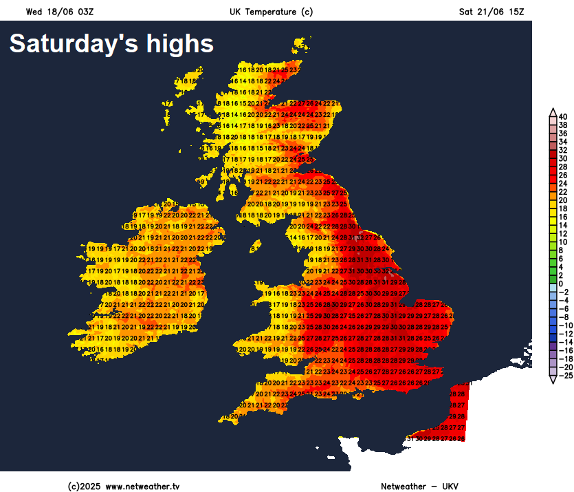
Temperatures will continue to rise through this week before peaking this weekend, with 30-32C widely across England on Saturday, similar across eastern England Sunday according to GFS,, but likely cooling off further west.
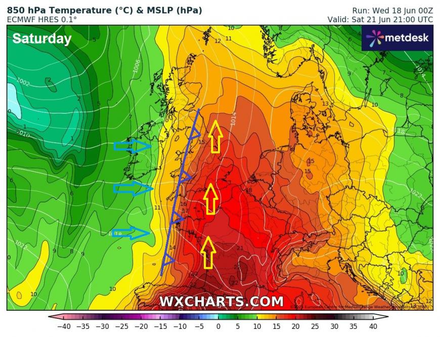
Warming up this week from the south, heat peaking on Saturday, before cooling off from the west on Sunday
However, a look at the 00z runs from other weather models, GFS looks on its own with 32-34C in E Anglia on Sunday, other models cooling off from the west more by then. Models have been struggling with how quickly heat is removed, but looks like Saturday the hottest day of the weekend. Could be some thunderstorms in the north and west on Saturday, as cooler and fresher air moves in against hot plume moving up from the south
Cooler and fresher early next week generally, with a more active westerly jet stream aimed at the UK, but could remain very warm across SE England. However, heat may return before month's end, 00z GFS has 39C on 30 June, the first 40C in June? This would beat the June record high of 35.6C set in 1976 by some margin! But with our warmer world, it can't be ruled out.
Extreme heat (record-breaking for June) showing for end of June on 00z GFS run
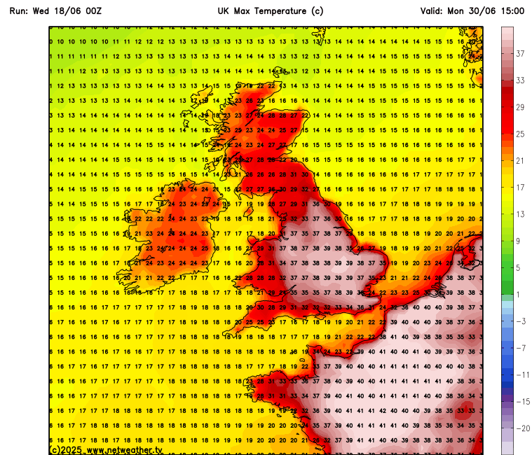
But the last day of June is still a long way off in forecasting terms and too far out to have any confidence what the weather may be doing, though the 00z GFS ensembles do indicate anomalously warm temperatures across southern UK at the end of the month.
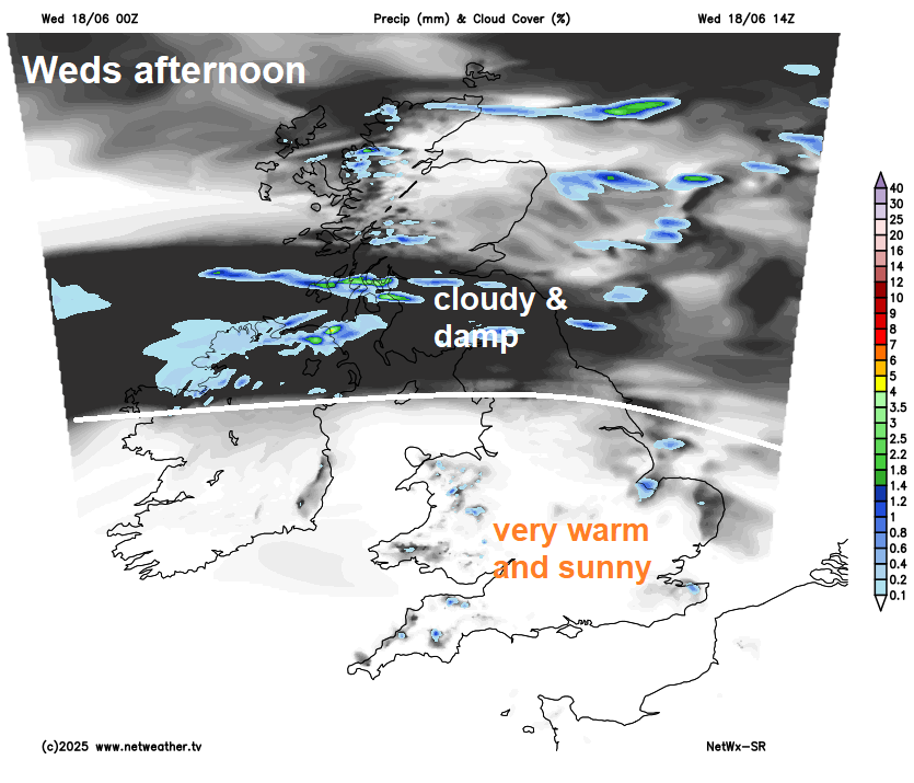
For now, not a lot is going on with the weather for the rest of this week, as high pressure firmly establishes itself across the UK. Most of England and Wales will be fine and dry, with plenty of sunshine, temperatures peaking at 24-27C inland. Cooler and cloudy across Scotland and N. Ireland- with some patchy mostly light rain or drizzle, particularly in the west of Scotland. Temperatures reaching 15-19C.
Thursday is looking like a much better day for Scotland and N. Ireland, joining most of the UK to a large fine day with plenty of warm sunshine, the warmth spreading north into Scotland too. Temperatures reaching 21-23C inland across Scotland and N. Ireland, 23-27C across England and Wales.
Little change on Friday, other than temperatures will be a little higher, another fine,, sunny and very warm day, hot in the south. Cloud will build to bring a few showers across Scotland and N. Ireland though. Temperatures reaching 26-28C widely across England, 23-26C elsewhere.
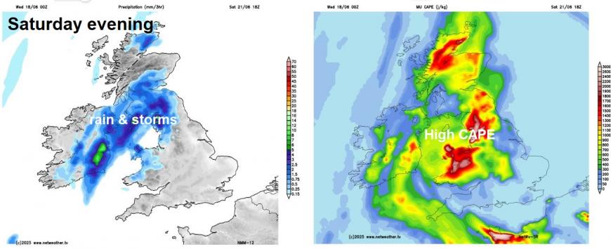
A hot day on Saturday, as a brief plume of very warm air originating from Iberia arrives and spreads north. However, cooler and fresher air will be trying to push in from the west later in the day, and where these two different airmasses meet is likely to trigger some heavy showers and thunderstorms across northern and western areas through the afternoon and evening, southern and eastern England likely staying dry until after dark.
Risk of some thunderstorms across northern, central and western areas by Saturday evening
Perhaps some early thundery showers across eastern England, otherwise a cooler and fresher feel in a brisk westerly or southwesterly breeze, with sunny spells and scattered showers in the west, perhaps still very warm across SE England and East Anglia though, with temperatures reaching the high 20s Celsius, low 20s elsewhere.
We look to the west next week, with the flow off the Atlantic bringing more average temperatures compared to above average this week, the southwesterly breeze feeding in scattered showers across the north and west closer to low pressure, perhaps some more organised rain for the north Tuesday or Wednesday. But the south and east of England likely staying mostly dry, with temperatures on the rise again here and humid too, as high pressure builds from the south. Quite a steep thermal gradient upstream next week between colder air across northern Canada and NW Atlantic and hot and humid air to the south over USA and western Atlantic - which is likely why next week is looking more westerly-driven, with a strong jet stream aimed at the UK
Hot and dry conditions may return for the last weekend and last few days of June, which will include the Glastonbury Festival - which is not looking like a washout mudbath for now, more likely very warm and sunny. But there is uncertainty this far out, so watch this space for a possible hot finale to June.
Loading recent activity...