Spring 2025 has officially been declared the UK’s sunniest spring on record by the Met Office, having already beaten the previous record, set in the famous “lockdown spring” in 2020, by 4 hours.
Sunshine anomalies in May have been quite variable around the country, due to a high frequency of days with high pressure over north-western Britain and northerly and north-easterly winds covering eastern England during the first two-thirds of the month. Many areas of eastern England have only had slightly above average sunshine, due to cloud often coming in off the North Sea. But for most of the rest of the country it has been another exceptionally sunny month, and for the UK as a whole it looks probable that May 2025 will end up comparable to May 2020 - less sunny than May 2020 over much of England and Wales, especially eastern England, but generally sunnier in Scotland and Northern Ireland. South-west Scotland and around the Isle of Man has been particularly sunny in May 2025 with a few sites having already exceeded 300 hours for the month.
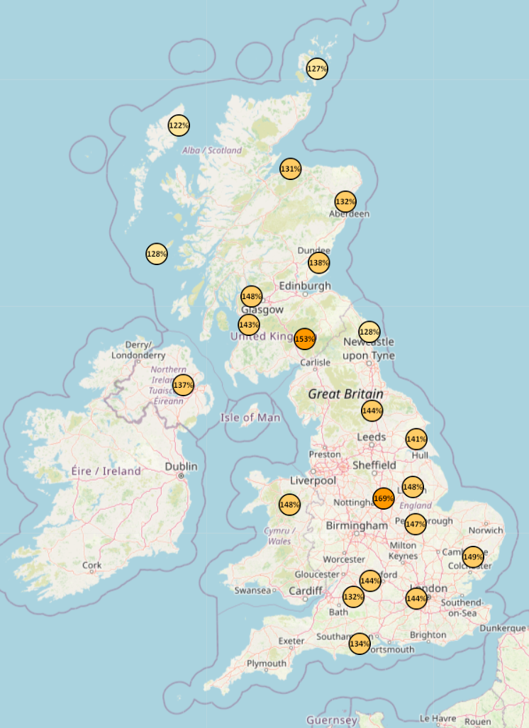
Sunshine anomalies for Spring 2025 - courtesy of Starlings Roost Weather
It also looks probable that Spring 2025 will have a reasonably even distribution of sunshine anomalies around the UK, as March and April were generally sunniest relative to normal in eastern England, and March in particular was less sunny over much of Scotland and Northern Ireland, but May’s sunshine anomalies are looking set to be much the opposite of those of March.
With some limited regional exceptions, most likely in coastal parts of eastern Scotland and north-east England, it probably won’t be a serious contender for the driest spring on record. Some western areas had quite a wet middle of April, and while May was remarkably dry up to around the 23rd with some sites recording no measurable rain, frequent rain during the last week of May has raised May’s rainfall totals to not far below the long-term normal in many regions. It has starkly illustrated the fact that when we’re looking to see if a particular month or season will be among the driest on record, it is easy for a few very dry weeks to be wiped out by one wetter week.
It is also set to be another warm spring. Spring 2025 overall is set to be rather less warm than Spring 2024 was, mainly because 2024 had a lot of warm wet humid weather with warm nights, while the often clear and sunny weather in spring 2025 has resulted in substantially cooler nights. But most people will not end up remembering 2024 as a warmer spring, as it was often predominantly cloudy and wet, and there was a period of cool daytime temperatures in the second half of April 2024 which stuck out in many people’s memories. General perceptions of how warm a season has been tend to be influenced mainly by the daytime temperatures, sunshine amounts and lack of wind and rain, resulting in 2025 generally being perceived as the warmer of the two.
This illustrates the issue that when examining statistics, one often needs to look at the bigger picture rather than focusing on just one or two metrics - often the mean temperature isn’t a good enough indication on its own of what it was like to live through a particular season. When looking additionally at sunshine, rainfall and daytime maximum temperatures, we get a more accurate picture, with spring 2025 coming out ahead by most other metrics.
A number of people have recently been asking me when we are next likely to get our summer back, illustrating that the frequent warm dry sunny weather this spring brought about a perception of summer having already established. In meteorological terms, summer doesn’t start until 1 June, and by some other definitions it starts even later than that.
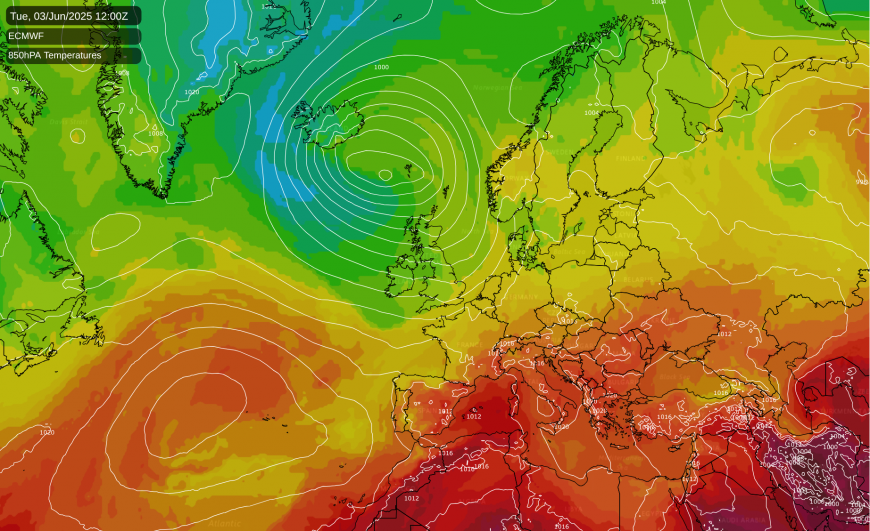
Generally so far my answer has been “into the second week of June”. Confidence is of course relatively low once you get more than 7 days out, but there is quite a strong signal among the medium to long range forecast models that the weather will continue changeable, albeit quite warm at times, with mainly westerly and south-westerly winds through to around 10 June.
The weather pattern that we’ll be getting isn’t normally associated with particularly warm weather, but sea surface temperatures are well above the long-term average in most parts of the North Atlantic, especially to the south-west of Britain, and this will result in these westerly types being warmer than we would normally expect. But most people are really asking about when the dry sunny weather will return, and for the next 10 days it often won’t be particularly dry or sunny.
Loading recent activity...