The weather looks to turn increasingly unsettled over the Bank Holiday Weekend, as a strengthening jet stream takes aim at the UK and brings in a succession of low pressure systems in off the Atlantic, bringing spells of rain or showers and cooler temperatures, but how long will it last?
A strengthening zonal (westerly) jet stream will push in from the Atlantic across the UK this weekend, its arrival will be heralded by a warm front pushing east tonight, bringing a band of rain east across most parts. This will be followed by a cloudier but more humid day on Saturday in the ‘warm sector’, the cloud thick enough to bring patchy rain or drizzle in the west. Meanwhile, a deepening area of low pressure will track northeast just north of Scotland - bringing a cold front east with further rain Saturday night for many parts. Clearer polar maritime air following the cold front, with sunshine and showers on Sunday, while becoming increasingly windy too.
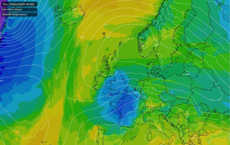
Strengthening jet stream aims at the UK from the weekend
During the first half of next, week the jet stream will be running west to east across the UK, bringing further shallow areas of low pressure and associated frontal waves east - which will bring further outbreaks of rain or showers. Timings and extent of the heaviest rain a little uncertain, but Tuesday could see a spell of locally heavy rain spread east across England and Wales during the day, followed by another spell of wet weather on Wednesday, but by then, uncertain how far north or south.
00z ECMWF looks particularly unsettled until later next week

00z and 06z ECMWF have quite an active frontal wave depression running east across southern UK on Wednesday, bringing a spell of quite wet weather across parts of England and Wales. GFS takes the low further north over Scotland. Models may be underplaying the strength of the jet stream running out of North America across the North Atlantic, so there could be changes to more unsettled conditions than GFS portrays at the moment.
Another low pressure system then moves northeast across Scotland on Friday, bringing more wind and rain to northern areas, but further south, there are signs from the models that the jet stream will shift north later in the week allowing a ridge of high pressure from the Azored to build further northeast across southern UK from Thursday. So rainfall off the Atlantic may become increasingly confined to northern areas by this time next week, while southern areas become drier, sunnier and warmer.

Meanwhile, all through next week, it looks to turn unusually hot for late May across Iberia, as a ‘heat dome’, caused by a strong upper level ridge of high pressure causing subsidence and warming at the surface, builds north out of northwest Africa and bringing high temperatures. Parts of southern Spain and southern Portugal are forecast temperatures to reach the mid to high 30s degrees Celsius later next week, the ICON model even shows 40C around the Seville area of Andalucia in the far southwest of Spain.
Heat building over Iberia next week, but uncertainty whether any of this will reach the UK next weekend

Some of this extreme heat in Iberia will spread north across France and further east over mainland Europe, but there’s uncertainty whether it will reach southern UK in the last few days of May. Model runs over recent days, had hinted at bringing a plume of heat up from Iberia and in across southern UK. Yesterday’s 12z GFS had temperatures on the last day of May, next Saturday, reaching the mid to high twenties across southern and eastern England, but this morning’s runs have backed off with the warmth somewhat, perhaps still 25C in SE England.
The potential for a very warm, dry and sunny end to May, after a spell of unsettled weather, very much depends on how far north the jet stream shifts later next week and if the models have got a good enough handle on this. There is a chance that the models are undeplaying the strength of jet stream, so it may not shift far enough north to bring any of that heat over SW Europe as far north as southern UK and, instead, cooler Atlantic air continues to flow off the Atlantic. But it's too far out to call for now. A chance of warmer drier weather to end May for southern Britain still looks a reasonable bet, for now. But perhaps not the hot weather that some tabloids have been predicting.

Looking further ahead into early June, again models have been signaling a return of blocking high pressure on the scene, so we could soon be back to drought after a spell of wetter weather. But this may change.


Recent daily runs of the subseasonal ECMWF weeklies have been signalling high pressure / heights present at times across much of Europe - bringing dry and very warm conditions - with above average temperatures.
Loading recent activity...