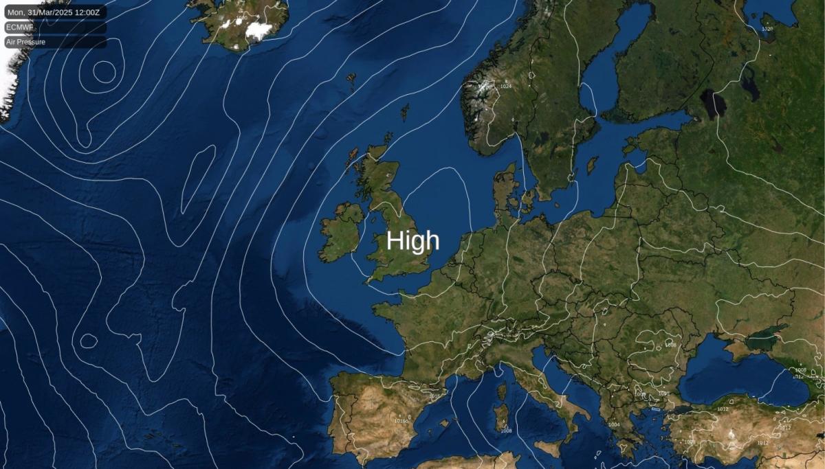
High pressure will be in charge of the UK's weather this week, bringing plentiful sunshine and Spring warmth - especially away from eastern and southern coasts. Overnight frosts are likely in places though, so if you have tender plants in the garden, take care.
High pressure will be the dominant feature across the UK this week, bringing settled conditions with warm, sunny days and chilly nights for most regions.
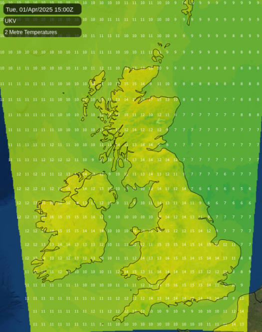
England and Wales will enjoy plenty of sunshine with just some light cloud at times. Daytime temperatures will reach 15-17C in London and the southeast, slightly cooler along North Sea and English Channel coasts where an easterly or southeasterly breeze is liable to keep temperatures a little lower. Some areas saw a frosty start on Monday morning with lows down to -1c or so, and these chilly nights are set to continue throughout the week.
Rural frost will be particularly noticeable in sheltered valleys and dips where cold air can pool overnight. So, for the gardeners among you, it's definitely one of those weeks to vigilant and protect any tender plants, especially in frost-prone locations. Early morning commuters may also encounter patches of mist in rural areas, though these should quickly burn off as the sun rises.
Scotland presents a more varied picture, with the far northwest and north experiencing cloudier conditions initially and a small chance of light rain on Monday. However, for most of Scotland, particularly the south and east, dry and bright conditions will prevail with warm sunshine. Glasgow and Edinburgh could reach 16-17C by Tuesday.
Northern Ireland will start the week rather cloudy with the possibility of occasional light rain or patchy drizzle, especially Monday morning. Brighter spells will develop through Monday with maximum temperatures reaching around 16C. Expect brisk southeasterly winds on Tuesday, though overall conditions will remain settled with improving sunshine as the week progresses.
The settled weather will continue into the latter part of the week across all regions. Temperatures are likely to climb, particularly in the west and south of the country where see 19-20C isn't out of the question by Thursday and Friday.
This warming trend will make it feel decidedly spring-like during daylight hours, but once again the significant diurnal temperature range means evenings will still feel quite cool, dropping quickly once the sun sets. The lack of cloud cover, which allows daytime warming, also permits rapid cooling at night - a classic feature of high-pressure dominance in early spring.
The wind will will be generally light at the start of the week (away from coasts), but it is expected to become increasingly breezy from Wednesday to Friday, initially along the south and west coasts before extending more broadly across the country. So, you may need to escape it to feel the warmth, especially closer to those eastern and southern coasts.
The weekend outlook maintains the theme of settled conditions. High pressure will continue to exert its influence, resulting in predominantly dry weather with warm days and chilly nights, but it is likely to move further north during the latter part of the week. This may allow the odd disturbance to head up from the southwest, bringing the threat of some showery outbreaks of rain here - something to keep an eye on but not a cast iron certainty by any means. There also remains a risk of overnight frosts, particularly in rural locations where winds are light. Some coastal areas may experience patches of low cloud or fog, especially in the mornings.
Loading recent activity...