It will be worth finding a sheltered, sunny spot on Sunday, out of the keen wind. It’s Mothering Sunday, just a little midweek reminder there. Colder air will take hold for the weekend, and at this time of year, that makes it feel chilly in the shade or breeze, but still lovely in the sunshine.
High pressure has kept our UK weather settled recently, but weather fronts will continue to slide past the far northwest, bringing rain to western Scotland. Here, it will be wet and blustery, whereas other parts can look forward to a good deal of fair weather, but it will feel colder.
 Aurora looking north over the Firth of Forth Weds 19th March 2025
There have been a few opportunities in the past week to see the Aurora and that may happen again on Wednesday evening. Frontal rain will be over the far NW of Scotland with cloud streaming ahead of it but there will be clear spells elsewhere.
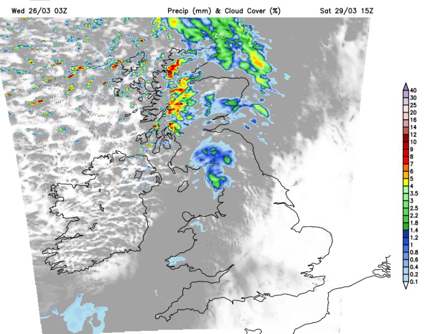
One cold front will bring rain during Thursday night, which will still be over SE Britain on Friday morning. Wet and windy weather will move across Scotland in the middle of Saturday, swiping the north coast of Northern Ireland and Cumbria, leaving behind heavy showers. Sunday looks dry, but it will be cold in the wind.
This cold air is coming down from the Greenland Sea. The capital, Nuuk is forecast to see a top temperature of -5C on Friday. Iceland had blizzard conditions with rain and snow and temperatures of +2C for Reykjavik at the weekend.
Here in the UK, most areas have seen a very dry March. Spain and Portugal have experienced an exceptionally wet month, with Madrid recording over nine times the average March rainfall. This weekend, the central Mediterranean will see unsettled weather with rain for Italy, Greece, Turkey and the Balkans, including Croatia.
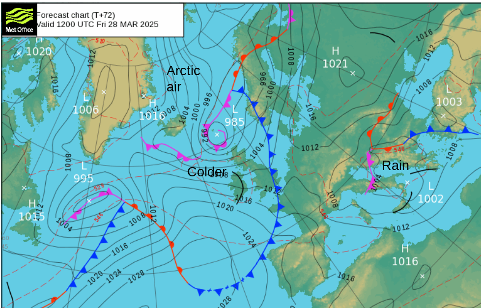
This cold front will bring lines of sharp convection to Scotland and Northern Ireland on Thursday evening, progressing southeastwards on Thursday night. Conditions on the roads through the Central Belt down to the Scotland/England border and for County Down could be difficult in these bands. A fresh southwesterly wind will veer to a westerly as the cold front rain becomes more patchy as it progresses through Wales and England overnight.
Friday will start off sunny but cold behind the cold front with a scattering of showers. These will mostly be of rain but also include hail, perhaps thunder and a wintry mix over the Scottish mountains. They will reach northern England and Northern Ireland in the morning. The frontal cloud and rain could take its time to clear SE London and Kent on Friday. It will feel cold in the wind and after dark.
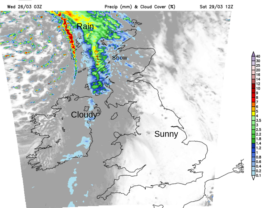
This weekend, there will be areas of lingering cloud but also good spring sunshine. Saturday morning should start fine for many before a frontal system arrives from the Atlantic. Cloud with patchy light rain will spread over Northern Ireland in the morning as a southerly wind picks up. Wet and windy weather will arrive for western and northern Scotland with a little snow for the Grampians as the winds freshen.
National Space Centre “There's going to be a partial solar eclipse in the UK on 29 March. It will start just after 10:00. The maximum partial solar eclipse in Leicester will occur at 11:04, with the Moon blocking about 33% of the Sun’s surface.”
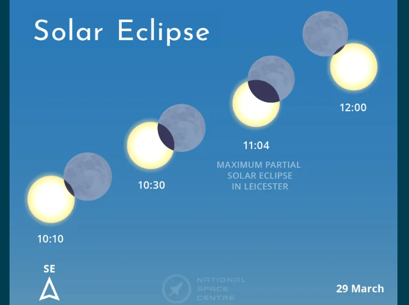 Partial solar eclipse on 29 March. Credit: © National Space Centre
We had a partial lunar eclipse early on the 14th. On Saturday, there will be a partial solar eclipse. It’s not going to go dark but if you have eclipse glasses, it will be worth a peek. Don’t look directly at the sun, use a pinhole through paper or card to project an image onto the ground instead. Northwestern parts will see increasing cloud, further east, south and for central regions, there should be clearer skies.
It will become windy and cold over the Irish Sea and over Scotland during the afternoon. The frontal cloud and patchy rain will move over northern England and Scotland, turning showery. Further south, it will remain more settled and temperatures will be 12 to 15C.
It will become windy for a time overnight for Glasgow, Antrim and Blackpool as the westerly flow strengthens.
By Sunday morning, the wind will have veered to a chilly northwesterly, but the heavy showers over Scotland will be easing. Many areas will be fine, bright, but feeling cold. Eastern areas will see more sunshine as western coastal counties will have more cloud and perhaps some damp weather for a time. As high pressure builds in from the southwest, the chilly wind will ease, and it won’t feel too bad by the end of the weekend, especially in the sunnier spots.
Loading recent activity...