Rather unsettled conditions will continue across southern Europe over the coming days, with areas of low pressure moving east bringing spells of rain and storms. Also parts of southern and central USA will see severe storms with a risk of strong tornadoes.
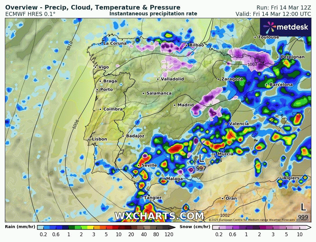
Tourists heading to Spain and Portugal this weekend may want to swap their sunglasses for umbrellas as Iberia is currently being hit by Storm Konrad, named by the Portuguese Met service. While prospects for next week don’t look much better, with further areas of low pressure moving in, including the newly-named Storm Laurence - bringing more rain to many parts of Iberia. Unsettled conditions also look to extend east across the Mediterranean too, with parts of northern Italy and the Dinaric Alps / Adriatic coast of the Balkan countries seeing some large rainfall totals too.
Over the other side of the Atlantic parts of the USA will be dealing with severe weather over the next few days, as a strengthening storm system looks to bring high winds and perhaps dozens of tornadoes, some strong, from Friday afternoon to Sunday afternoon across central, southern and eastern states.
Iberia
Storm Konrad, named by the Portuguese meteorological service, has already caused chaos across parts of Iberia. Across Andalusian, there were 294 incidents throughout Thursday resulting from flooding of homes and garages, as well as flooding on roads and streets.
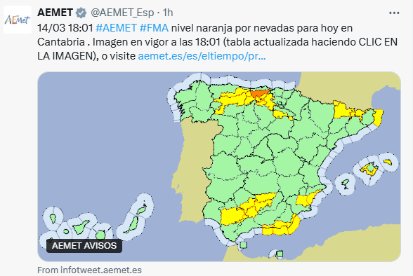
Cantabria is under orange alert for snowfall, along with eight other communities in the northern and northeastern half of Spain under a yellow alert. The Balearic Islands and Andalusia are also under yellow warnings for heavy rain, thunderstorms, storm surges, and strong winds of up to 70 km/h in Andalusia. Over the weekend, the rain and snow will ease, but some showers are still possible. However, it will be on the chilly side, with temperatures between 5 and 10°C below normal, as cold air over northern Europe spreads south in wake of Storm Konrad moving east.
However, another storm looks to arrive off the Atlantic on Monday, now named Borrasca (Storm) Laurence, bringing further rain and wind to Iberia – Portugal bearing the brunt of most rainfall. Another system then moves in close to the west after mid-week, bringing more rain or showers at times, but it will at least turn warmer next week.
Italy and the Balkans
Two areas of low pressure will move in from the west Friday and Saturday bringing very unsettled weather to the northern half Italy, The Alps and the northern Balkans with heavy rain and thunderstorms, snow in the mountains and strong winds. One system is crossing the area right now, the other between the end of today and tomorrow. Rain and thunderstorms could be locally very intense, with possible significant accumulations with a risk of flash-flooding - in particular between Tuscany, Emilia Romagna and the Venice areas of Italy and also along the Adriatic coast and Dinaric Alps of Slovenia and Croatia. Flash floods have already swept through the streets of Sesto Fiorentino, a suburb in the NW of the city of Florence in Tuscany today, sweeping away cars on the streets.
Snowfall is expected above 1000 meters in the Alpine region, but with significant accumulations above 1500 meters above sea level. Drier weather is expected next week.
Friday afternoon, local time, will see thunderstorms capable of producing severe weather, including tornadoes and damaging winds over the Mississippi Valley states. There is potential for severe storms to bring a very dangerous and life-threatening situation in portions of Iowa, Missouri, and Arkansas before expanding into portions of Nebraska and Minnesota and extending southward to portions of northeastern Texas and Louisiana. The main threat from the storms will be powerful wind gusts reaching near 100 mph as the thunderstorms organize into one or more lines – which will move east-northeastward and may cover hundreds of miles. Such systems are labelled derechos. Ahead of the main line of storms, some individual discrete thunderstorms, called supercells, may develop and these may have the potential to produce multiple tornadoes, some perhaps strong.
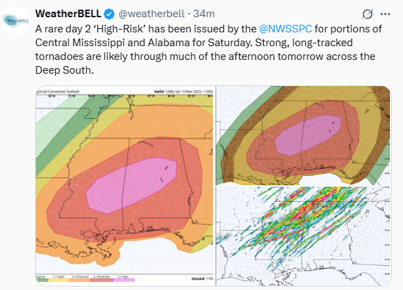
A rare day 2 high risk of severe storms forecast by the Storm Prediction Center for Saturday across Mississippi and Alabama:
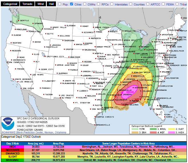
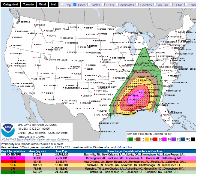
On Saturday, the storm system shifts further east and southeast across the Deep South. By then, parameters look favourable for a significant tornado outbreak across Mississippi, Louisiana, Alabama and southern Tennessee. Instability across these areas on Saturday afternoon is expected to be unusually high for mid-March in the south, which combined with increasingly strong speed and directional sheer, as a low-level jet stream cranks up by early evening, brings an environment supportive of a few long-track large tornadoes across Alabama and Mississippi - where the jet streak's right entrance is located by evening. As well as the danger from tornadoes, there is a risk for flash-flooding. Like Friday, the all severe hazards risk from these storms looks to continue overnight too. A rare day 2 High Risk of severe weather has been issued for parts of Mississippi and Alabama. This includes a 30% risk of tornadoes within 25 miles of point.
Loading recent activity...