With just a few days left, looking back over this winter, any unsettled spells of weather have generally not lasted more than a week, with periods of high pressure-dominated weather in between unsettled spells tending to last longer. The last spell of anticyclonic weather, back in early February lasted over 2 weeks, preceding a more unsettled Atlantic dominated spell of weather lasting a week just coming to an end. Despite the dry weather during the first half of this month, rainfall has recovered to near average levels for England and Wales following recent wet weather.
High pressure will build in from the west from today, so showers will tend to fade and it will become generally settled through to the middle of next week. However, not all parts of the UK will benefit from high pressure, with Scotland and N. Ireland prone to more in the way of cloud and occasional rain off the Atlantic, as fronts brush the far north and northwest.
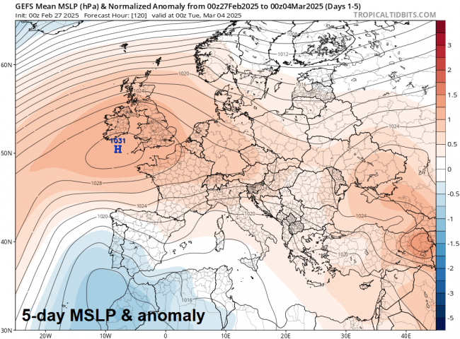
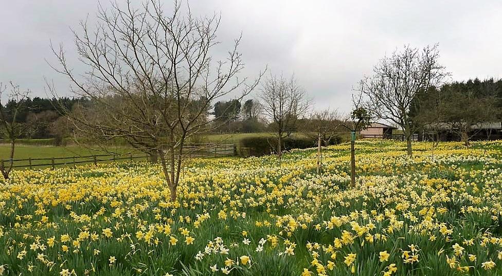
England and Wales will turn drier from today, it will be generally sunny by day with average temperatures (7-10C) until next week, but the nights will be chilly - with a risk of frost. Remaining dry through much of next week too, but turning milder, as a southwesterly flow strengthening ahead of an upper trough and surface low pressure slowly edging in towards the west, while high pressure retreats east. Eventually it looks like low pressure will win out from the west later next week, heralding another spell of unsettled weather with spells of rain and occasionally windy.
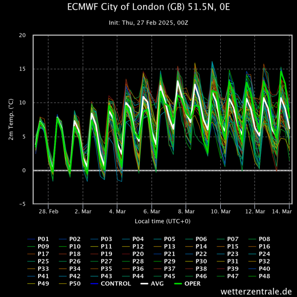
Temperatures on the rise through early March. London below:
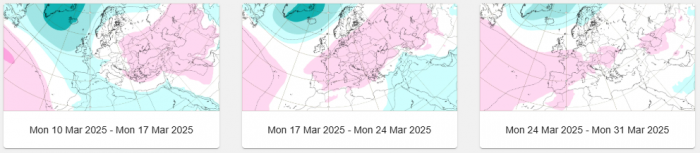
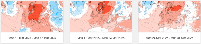
But what will the rest of March bring? Looking at the ECMWF Extended Range Weekly Anomalies for sea level pressure - it forecasts low pressure to continue to dominate over NW Europe between Mon 10th March - Mon 17th March. After that through to the 31st, it has a signal for low pressure to continue close to the north, but for high pressure to gain more influence towards the south. So after unsettled and sometimes wet conditions for all between 10th-17th, it may turn drier in the south and east, continuing unsettled and wetter in the north and northwest. For all 3 weeks between 10th-31st - temperatures are looking above average.
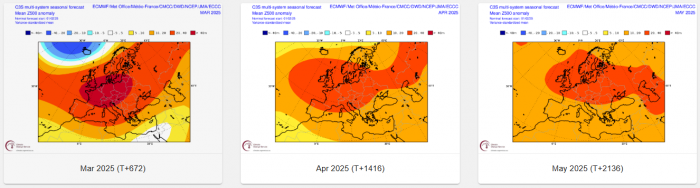
Moving on to the rest of Spring, starting with the seasonal model output from ECMWF, UK Met Office and NCEP released earlier in February and they were all going for high pressure-dominating for April and May, with above average temperatures. This backed up by the multi-model picture too. The March update won’t be out for another week or so, which may well change the outlook.
So, as is tradition in our seasonal outlooks, looking that far ahead, we use analog years where spring months followed similar patterns of ENSO and also looking at other drivers that may shape weather patterns through the seasons.
La Niña conditions are present. Equatorial sea surface temperatures (SSTs) are near-to-below average in the central and east-central Pacific Ocean. The NOAA expects La Niña conditions to persist in the near-term, with a transition to ENSO-neutral likely during March-May 2025 (66% chance).
Years since 1980 which saw weak La Nina conditions present in February before weakening to Neutral in Spring were: 1981, 1986, 1996, 2001, 2006, 2009, 2014, 2018. A composite reanalysis of those years for April and May at 500 hPa shows the following:
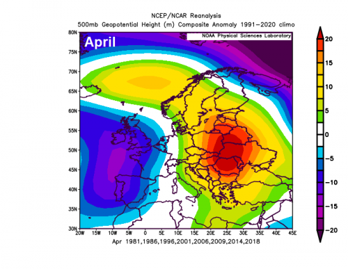
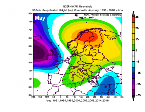
Upper trough close to the west and southwest and ridging to north and east in April, upper trough close to the west and ridging to the east in May. This is quite different to the February seasonal outlook from the models - which indicate high pressure being dominant both months.
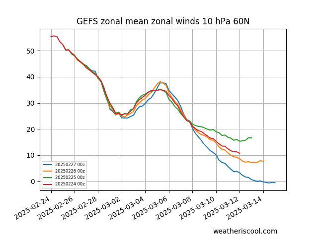
However, the big elephant in the room, that may not be picked up by the models yet and could skew the outlook proposed by them, is the increasing potential showing in the models for a sudden stratospheric warming from mid-March.
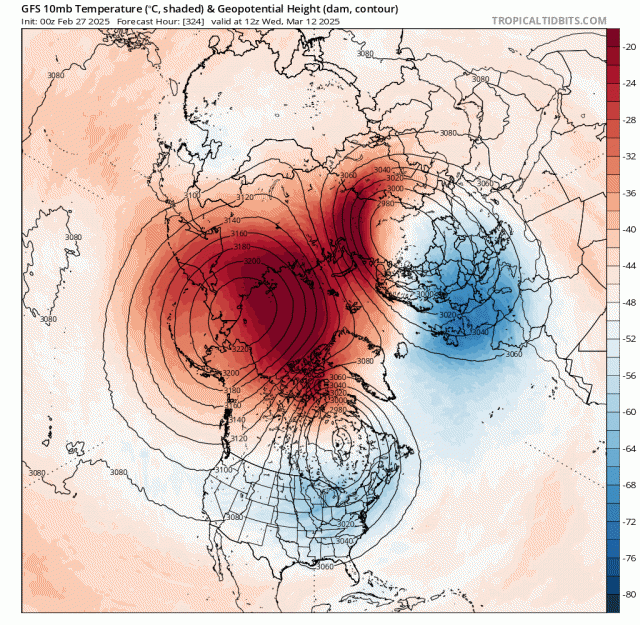
The 00z GEFS mean heading to a reversal of winds at 10 hPa towards mid-March, EPS mean yesterday similar too. The 00z GFS goes for a split of Strat Polar Vortex by then. GFS continues to forecast initially a displacement of the polar vortex towards NE Europe and NW Russia, caused by wave number 1 warming towards the North Pole from Alaska / eastern Siberia side of the arctic circle. This isn’t forecast to affect the troposphere, with a disconnect between the stratosphere which has been present through much of the winter. Eventually GFS splits the Stratospheric Polar Vortex (SPV) by mid-month - with a reversal of winds in the polar stratosphere to easterly, this may propagate down into the troposphere - which could have big repercussions to weather patterns heading through the end of March and April. However, there is a great deal of uncertainty, for now, if the SSW occurs, whether it will be an early final warming if it does, or the PV bounces back again.
If it does occur and connects to the troposphere, it could bring high latitude blocking and perhaps usher in colder conditions from the east or north in early April. Though high latitude blocking does not always equate to colder weather in winter or spring.
So, quite mixed signals for spring, which will be discussed and analysed in the Spring forecast which will be issued in the next few days.
Loading recent activity...