As the warnings ease for parts of the UK and Ireland this weekend will be full of repairs and clearing up for those areas battered by Storm Eowyn. Fallen trees and power lines, damaged roofs, tiles and fences. Ongoing transport disruption as trains, planes and ferries and staff will have to adjust after the cancellations.
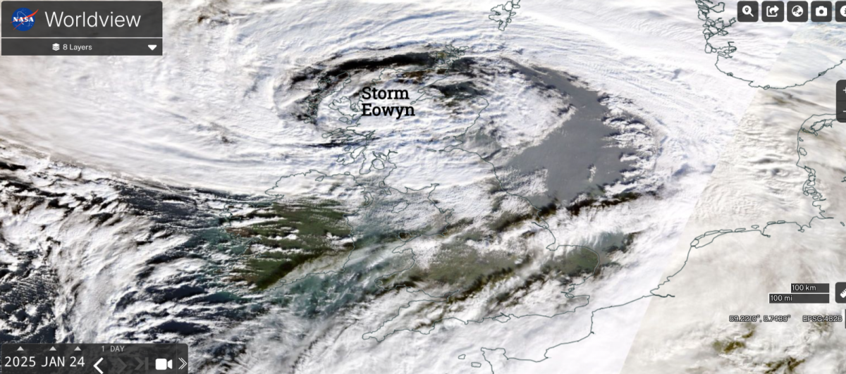
All of Ireland, Northern Ireland and some of central and southern Scotland were covered with rare red wind warnings from the UK Met Office and Met Eireann. Amber and yellow wind warnings continue into Friday night. There is still the risk of coastal flooding and large waves for the far northwest. The storm will continue northwards, away from northern Scotland over the Norwegian Sea by Saturday.
Cold air is being pulled in from the north Atlantic behind Storm Eowyn and after today’s rain there are warnings for ice across Northern Ireland and Scotland overnight. Around the storm, the gales and high gusts continue as precipitation from the wrap-round occlusion continues. As this mix of rain, sleet and snow continues for northern Scotland there will be wintry showers whizzing in from the west. These initially catch the northern counties of Northern Ireland tonight but the focus will shift across mainland Scotland by Saturday morning with a smattering from the west but reaching far inland. It will feel cold.
“Icy stretches and some snow showers will result in some hazardous driving conditions.” MO
Much of England and Wales will be dry tonight but there will be a narrow band of rain moving from Wales and SW England this evening across to The Wash and Isle of Wight by the small hours. It could bring some squally conditions but should be away from Kent before dawn leaving sunshine for Britain on Saturday
Winds
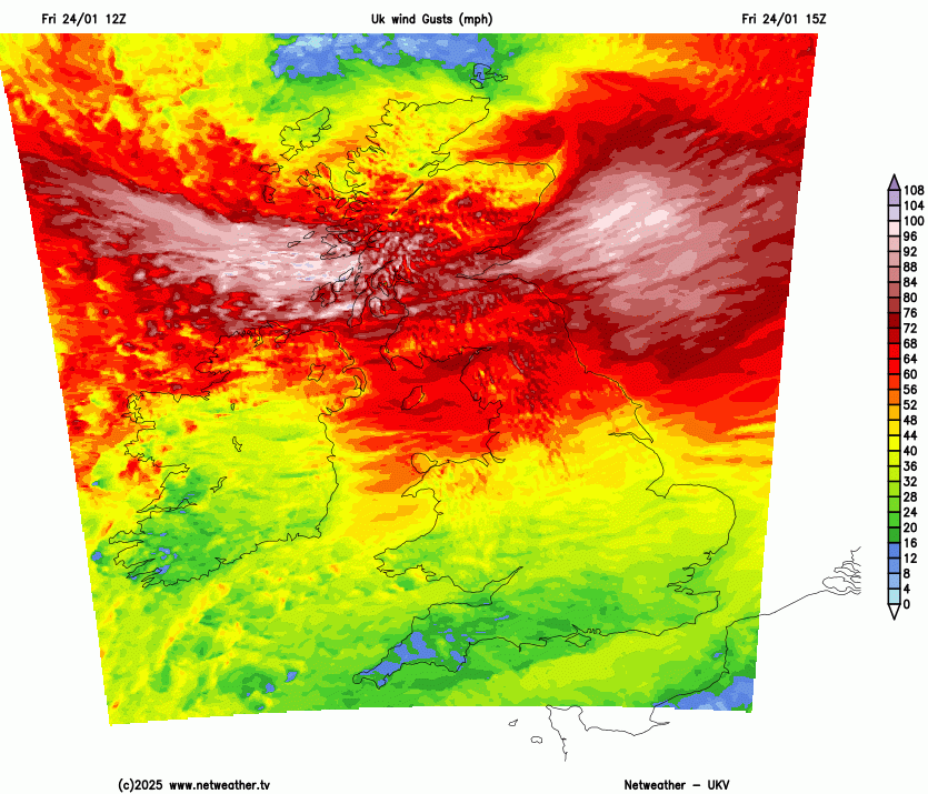
It will remain windy this evening for the northern half of the UK. The core of intense winds and severe gales will move from the Central Belt over northern mainland Scotland and the Western Isles this evening. Reaching Orkeny around midnight and continuing northwards to Shetland before dawn on Saturday. Mainland Scotland down to the Irish Sea will remain windy into Saturday morning but not like today. Southern Britain will start Saturday with light winds but a small low pressure will bring unsettled weather to Northern Ireland in the afternoon and the westerly winds will back to a southerly. That little low could then bring more windy (but not stormy) weather to western Scotland on Saturday night.
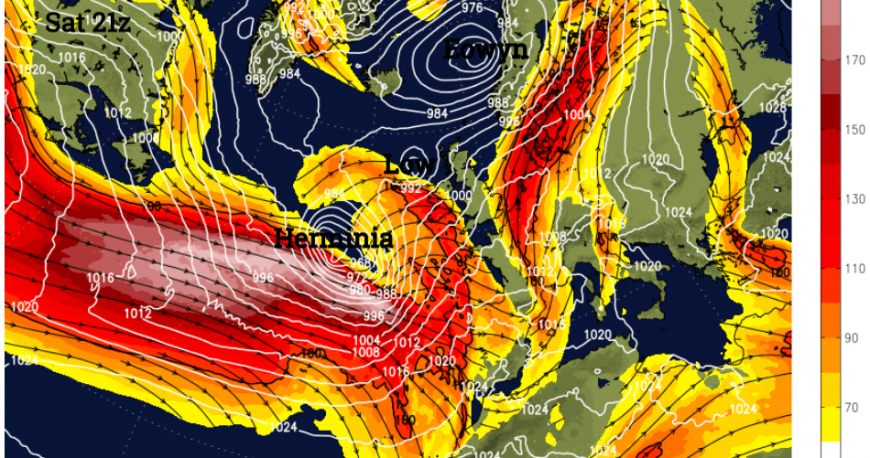
Another low pressure is heading our way, caught up on the very strong jetstream which developed Storm Eowyn. It will be a different event but will hamper repairs and bring more wet and windy weather to the UK.

Looking to the southwest early on Sunday this new Atlantic low will push strong winds and gales over the West Country, Wales, up through Ireland and could reach much of the UK by the end of the weekend. Maybe not reaching northern Scotland.
This low, Herminia, has been named by AEMET, the Spanish Met. Service who are in a different naming group, hence H not F.
‘Although [Herminia] will not head towards our territory, its proximity will give rise to a widespread storm in the [Iberian] Peninsula and, to a lesser extent, in the Balearic Islands.’ AEMET
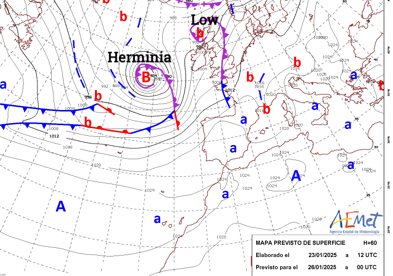
This next major low will stick around into the new week. There are already yellow wind and rain warnings for the west and south of the UK. Southern Britain will have milder, wet and windy weather but Scotland will be cold and frosty and there could be snow later on Sunday for northern hills as the frontal rain from the south meets the cold air. There will be heavy rain and thundery showers with several spells of wet weather leading to the risk of surface water and river flooding in the south.
Storm Eowyn data
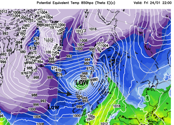
Provisional data shows Storm Éowyn reaching a minimum pressure of 938hPa by 2am on Friday after undergoing explosive cyclogenesis. Pressure fell 52hPa in 24 hours to 6pm on Thursday. Northern Ireland recorded its lowest pressure since 1900 down to 949hPa.
Met Eireann said that Ireland had recorded its strongest wind gust on Friday morning with 114mph at Mace Head. The centre of Eowyn then moved over the Scottish island of Tiree recording a pressure reading of 941.5hPa, possibly the lowest Scottish pressure in 30 years.
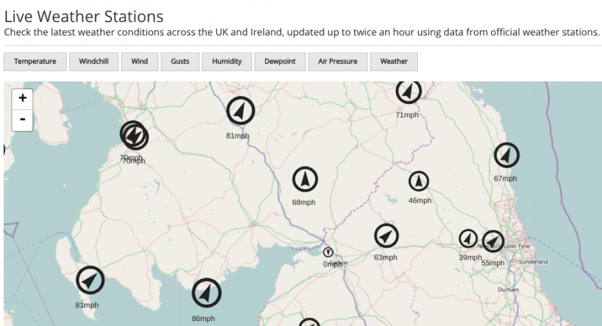
Drumalbin in South Lanarkshire recorded its strongest gust on record, 100mph. More exposed bridge locations saw 102mph on the Tay Bridge after closing to all traffic and 99.1mph on the Queensferry Crossing. Glasgow airport saw a gust of 82mph and Edinburgh airport 71mph as the travel disruption continued. Main routes such as the M8 and A1 were closed as lorries overturned. BBC News reported that “More than one million customers are without power across the UK and Ireland, including 725,000 in the Republic of Ireland”
Loading recent activity...