The next few days will often be bright, sometimes sunny, but there will still be areas of cloud pulling down the temperatures. Still no significant rain in the forecast.
There was some rain on Tuesday, but not enough. It may have wet the grass yet overall, this is another week with little rainfall and ongoing drought in some parts of the UK.
Sometimes the radar has not been showing the true story on the ground. The showers in the southwest have been from medium-level cloud earlier in the week, which results in those big splatty raindrops. The radar can over-read in this setup. Not such heavy showers as the bright echoes may suggest.
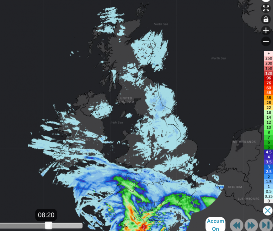
Netweather Radar 24 hours accumulated totals Tues - Weds 20th August
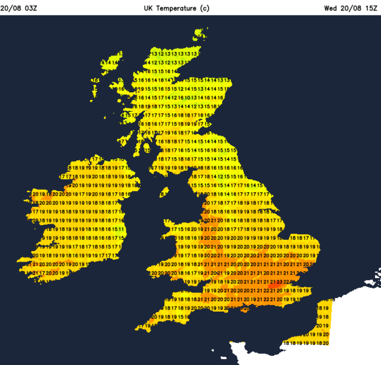
And along the east coast of Britain, the thick and gloomy stratocumulus has produced wet weather, which the radar can underread. SE Scotland had a dreich Tuesday morning with drizzle that would slowly soak you. The North Sea is fairly warm at this time of year and the current NE/E flow is bringing cooler air our way. Plenty of cloud is resulting and this continues into the weekend, from the north and northwest but it will be quite tricky to forecast the detail. Under the damp cloud temperatures will be subdued, but as soon as the sun breaks through, they respond and will leap up at the weekend when warmer air returns. On Monday, in warmer air and sunshine, western Scotland saw 27.6C in Strathclyde and 26.5C in Highland. On Wednesday, the highest temperatures were away from the cloud and reached the mid 20sC. It’s not the heat of last week; Wisley in Surrey was the highest at 26C.
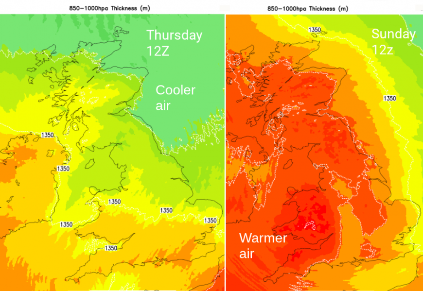
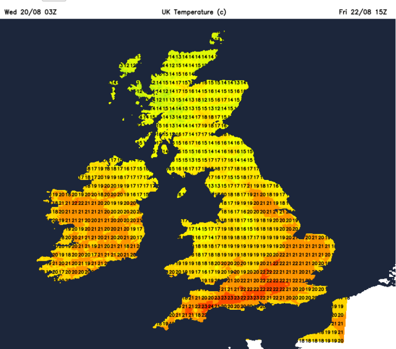
The current northerly flow is feeling much cooler. There have even been mutterings about popping the heating on. Or should that just be a jumper? It will be cool tonight and first thing on Thursday morning, away from SE Britain. With high pressure nearby the winds are often light inland, but there will be a shift from this cool northerly flow around the eastern side of the high to a warmer southerly. The High begins to move over the North Sea, although holding low pressures away over the Atlantic
Wednesday
A weak cold front has been working its way southwards overnight. This has brought thicker cloud to central Britain with some patchy drizzle and it’s extending over southern Britain. Things will brighten up for many parts today. The northeasterly flow will always keep a higher chance of cloud and cool breeze onto eastern coasts from the Forth down to Kent. There will also be stubborn cloud for western Ireland, which could linger into the afternoon for County Fermanagh. Temperatures will widely be in the high teens to low 20sC and in the sunshine, it will feel pleasantly warm
Tonight, there will be mostly clear skies with the northerly breeze for East Anglia. Then the nippy start for Thursday.
Thursday
There will be a light NNW breeze through Enlgnad, which will still be noticeable for the coasts of East Anglia and north Kent. It will be a fair, dry day with bright or sunny spells.
It could be colder for inland northern Scotland on Thursday night with hardly any breeze.
Friday
On Friday, a weak occluded front will dangle in from the northwest and could bring just a few showers and a bit more cloud, for Northern Ireland and the Western Isles. Southern counties of England could reach 23 to 25C inland and again, feeling fine in the sunshine with little breeze.
This run of quiet days continues for the end of the week. It’s mostly dry and fine with light winds. The cloud amounts vary, so changing from grey to bright to warm sunshine as the high pressure stays nearby into the weekend.
Loading recent activity...