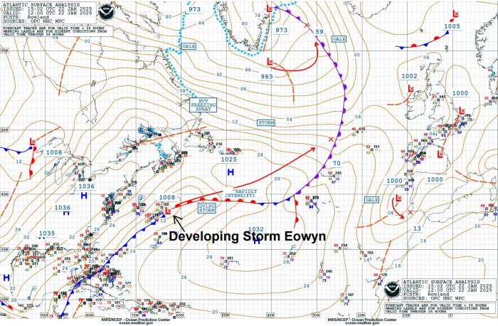
Potentially the strongest windstorm to hit parts of Britain for years is set to arrive on Friday. Storm Eowyn has been named and looks to bring potentially dangerous winds for Friday across Ireland & northern Britain.
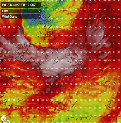
00z model runs this morning were worryingly showing the low at its deepest just off northwest Ireland Friday morning circa 933-936 hPa, with 00z ECMWF showing 130mph gusts offshore of western Ireland, while 00z UKMO had 121 mph & ICON 118mph gusts off western Ireland. Models showing inland gusts of 80-90mph across Ireland, N. Ireland along with parts of northern England, southern and central belt of Scotland. This includes large populated areas of Dublin, Belfast, Liverpool, Newcastle, Glasgow and Edinburgh.
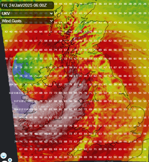
UKV showing over 115mph gusts off western Ireland, 90-100mph over Irish Sea, 85-95mph gusts over N England
Met Eireann have issued danger to life Status Red wind warnings for most counties in Ireland, away from the southeast which remain under orange warnings. All the red wind warnings are for gusts in excess of 130 km/h (80mph).
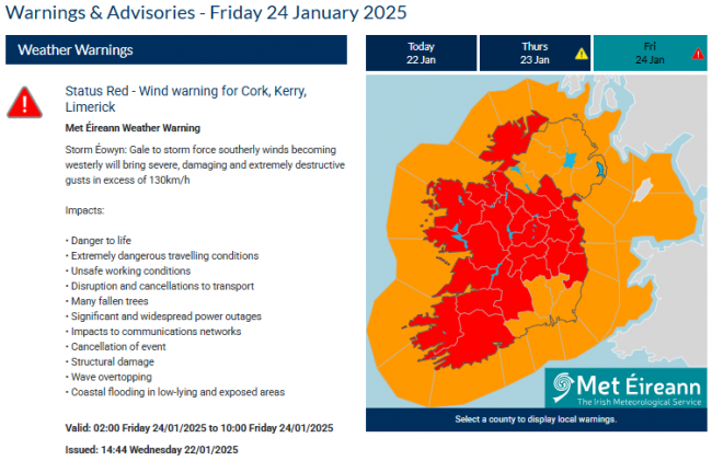
Met Éireann Weather Warning
Storm Éowyn: Gale to storm force southerly winds becoming westerly will bring severe, damaging and extremely destructive gusts in excess of 130km/h
Impacts:
• Danger to life
• Extremely dangerous travelling conditions
• Unsafe working conditions
• Disruption and cancellations to transport
• Many fallen trees
• Significant and widespread power outages
• Impacts to communications networks
• Cancellation of event
• Structural damage
• Wave overtopping
• Coastal flooding in low-lying and exposed areas
Meanwhile, the Met Office have issued Amber Warnings in force between 6am and 9pm Friday for wind across N. Ireland, north Wales, N England, central and southern Scotland for 60-70mph gusts widely, 70-80mph gusts in some areas, 80-90mph on exposed coasts and hills.
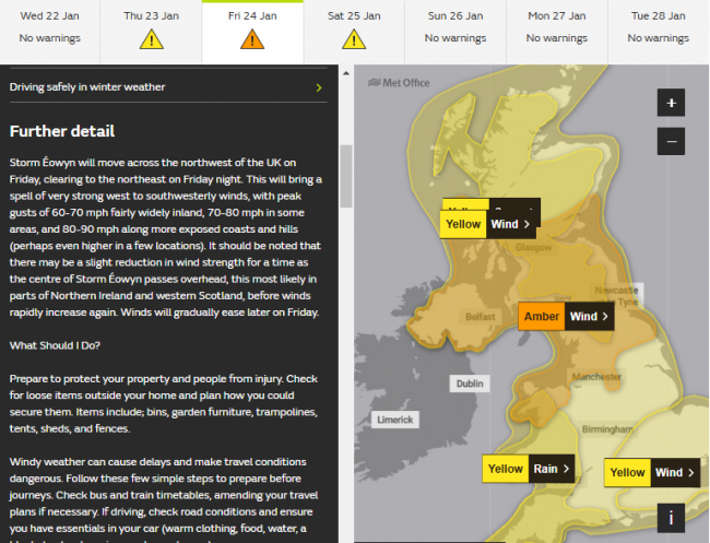
Yellow winds warnings cover the rest of the UK. A Yellow rain warning covers SW England and Wales – where as much as 40-60mm may fall over higher ground. While a yellow snow warning covers inland Scotland for temporary accumulations before snow to turns to rain.
Storm Eowyn is forming off the eastern seaboard of North America today, a low pressure system that is tied with a baroclinic or frontal zone stretching southwest into the Gulf of Mexico. This boundary separates very cold arctic air over most of central and eastern North America and warm tropical air over the Gulf of Mexico and western North Atlantic. The same baroclinic zone brought snow to the Deep South on its cold side, with several inches settling in New Orleans and snow settling in Houston and east to NW Florida, even on the beach.
This huge temperature contrast over southern and southeastern USA is fuelling a 260mph jet stream that is pushing east over the North Atlantic – which will be the catalyst for the rapid deepening of Storm Eowyn over the next 48 hours.
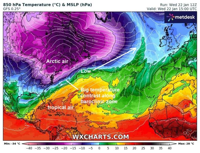
Storm Eowyn will be swept east with the very strong jet stream over the North Atlantic over the next 24 hours, as it the low moves over on to the polar side of the jet stream and also increasingly into the developmental left exit of the jet on Thursday afternoon – it will undergo rapid intensification on approach to Ireland. The left exit of the jet is where strong winds diverge aloft – creating a vacuum which has to be filled by air converging at the surface and rising to fill the void. As mentioned, the low is modelled to be at its deepest to the NW Ireland – this could mean the strongest winds are experienced across western Ireland on the southern flank of the low, with gusts exceeding 100mph with exposure.

However, some models also show 100mph gusts over coastal N. Ireland, Irish Sea and western coastal SW Scotland – with gusts of 80-90mph across SW Scotland, Cumbria and Pennines of northern England.
Home owners and businesses in the red and amber warning areas should finish preparations to secure property before dark on Thursday and people should heed these warnings and stay indoors – as such strong winds forecast will be life-threatening.
More discussion and chat in the Netweather community forum Storm Éowyn
Loading recent activity...