We're moving from a period of high pressure to a much more unsettled pattern with the potential for some very strong winds. This change will be triggered by a potent northerly blast over North America which will help to fuel the jet stream.
A marked shift in the weather regime is coming. We are currently in an anticyclonic spell. Many of us have anticyclonic gloom – quite a common weather type since early November 2024. However, this is set to change during the coming week. By next weekend, we look set to be in a very changeable south-westerly type, with low pressure dominant and potential for some very strong winds.
A few days ago, some forecast model runs were going for a Scandinavian high bringing cold air in from the east, and potential for some snow. But it now looks very likely that the jet stream will power up over the North Atlantic before the Scandinavian blocking high gets to establish.
The shift towards more unsettled weather with low pressure will start this coming Tuesday/Wednesday. But it is especially starting next Saturday that we can expect deep depressions to start coming in with strong winds.
There is still a chance of some of that colder continental air making it into northern parts of Britain late next week, which, when fronts come in off the North Atlantic and collide with this colder air, may produce some snow, mainly over high ground. But by next weekend it is forecast to be generally mild.
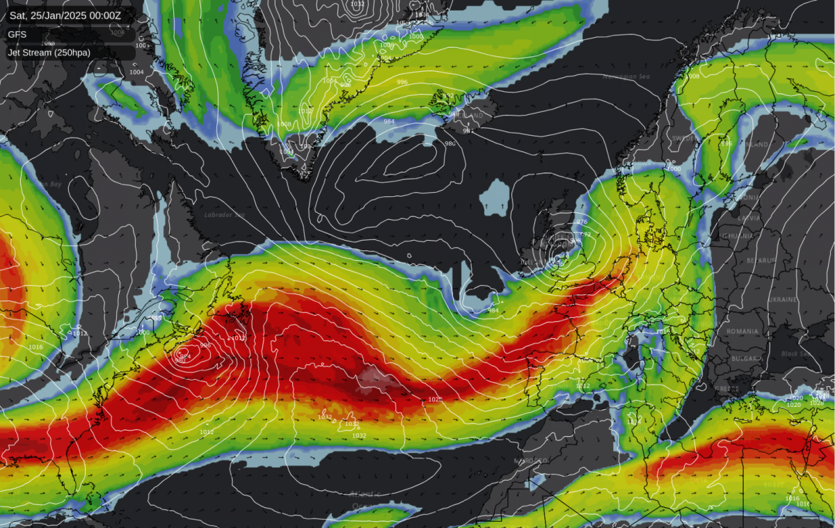
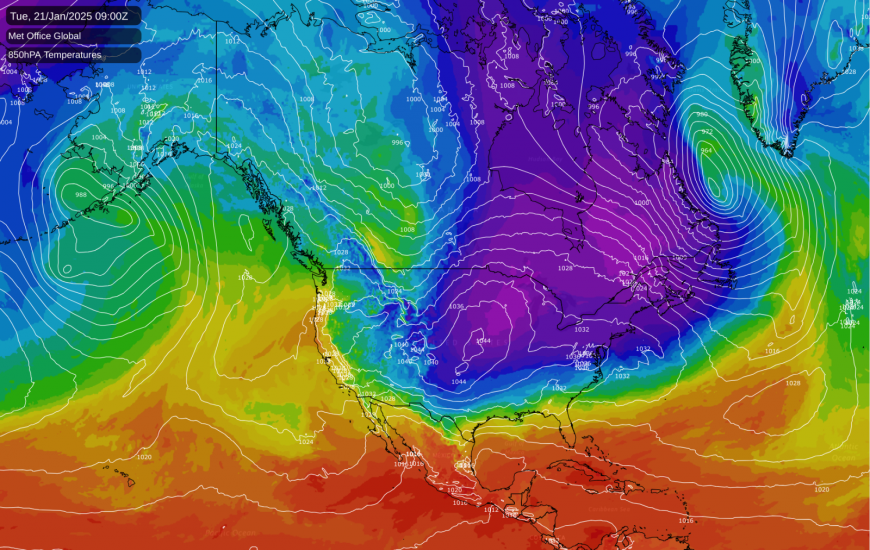
One major trigger for the powering up of the jet stream and deep depressions will be a potent northerly blast over Canada and North America. By Tuesday, temperatures are forecast to be well below the long-term average over a large majority of the eastern half of North America. In inland parts of north-eastern USA, temperatures are forecast to reach only around -20C during the daytime and to fall below -30C at night in some regions. The Guardian has reported that Donald Trump's inauguration could well end up as the coldest inauguration since Ronald Regan's back in 1985. A large scoop of this cold air will come into the North Atlantic starting on Tuesday and Wednesday. The stark contrast between this very cold air mass and relatively warm seas will help to trigger cyclogenesis and deep low pressure systems, which will contribute to a general fall in pressure in the North Atlantic.
In these situations, when the jet stream is aligned from north-west to south-east as it heads over the Atlantic, some of that cold air can make it across to the British Isles and result in some snow events, especially in northern and western Britain. But on this occasion, it looks probable that the jet stream will be aligned more from south-west to north-east, giving mainly south-westerly winds and keeping the cold North American air locked in the western half of the North Atlantic.
There is a lot of uncertainty over where and when the strong winds will take place. Several recent model runs have had a deep depression moving close to or over the British Isles on next Saturday 25th. The GFS model has had some especially vicious lows, and yesterday's 12Z run had wind gusts of over 80 mph locally in the English Channel. The GFS model is notorious for overblowing depressions at this time range, so it is unlikely to be quite as severe as that, but there is potential for damaging winds.
If we avoid damaging winds next Saturday, the chances are we will get some very windy weather shortly afterwards, as there will be a succession of deep lows developing over the North Atlantic and heading in our general direction. Although we had a major wind event on 6/7 December 2024, for the most part this winter has so far been relatively quiet and often dominated by high pressure, so the change to a very windy and unsettled regime may be a shock to the system for many of us. But wet and windy weather is quite normal at this time of the year.
Longer range outlooks, such as from the ECMWF and the Met Office, are suggesting that this mild, wet and windy pattern could persist for a while into February. But there is a substantial chance of high pressure again playing more of a role in our weather during mid to late February, with the jet stream pushing further north and sending low pressure systems to the north of the British Isles. There is a chance of it remaining very mild, if we retain mainly south-westerly winds, but if the quieter weather brings in continental air, then we could see colder, or at least closer to normal, temperatures for many during the second half of February.
Loading recent activity...