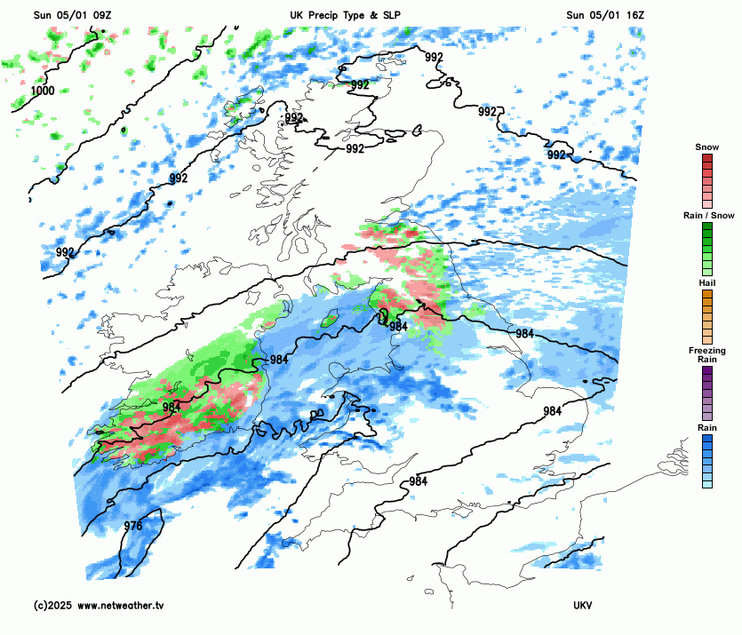
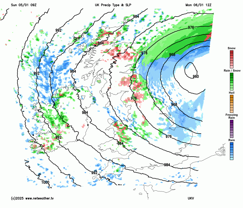
The severe winter weather in the North shows no sign of easing, as a still-deepening depression brings further snow and strong winds to many areas, before clearing into the North Sea on Monday. Cold conditions are expected to persist well into next week.
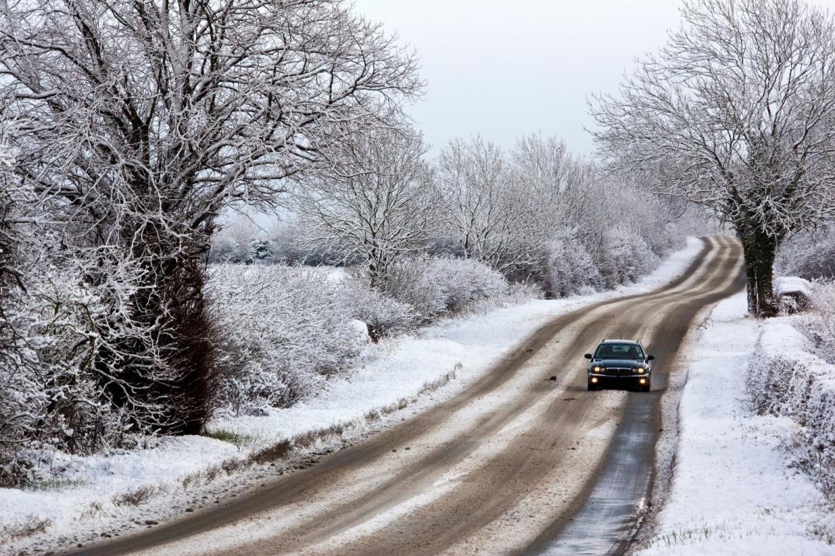
The severe winter weather in the North continues into Sunday afternoon, as a still-deepening depression moves across central parts on its journey into the North Sea. This will bring more disruptive snow and strong winds to northern England, the South and East of Scotland and North Wales for a while. Several high-level roads over the Pennines, Cumbrian Fells and Southern Uplands have been blocked by drifting snow, with up to 40cm expected on higher ground. There have also been power outages and airport closures making travel difficult, but conditions aren't quite so bad across the North and West of Scotland, with just a few wintry showers here.
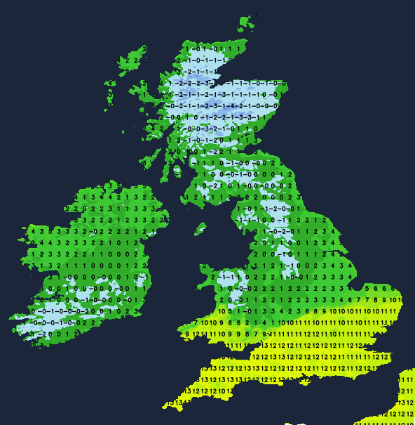
Yellow and amber warnings are in place until this evening across much of the country for further snow and ice in the North and heavy rain in the South.Across the Midlands and in the South, the snow has turned to rain bringing a thaw, with further showers likely here—some heavy—in much milder conditions. This has led to huge temperature contrasts across Britain, with 12 or 13C likely this afternoon across East Anglia and in the South, while further North temperatures remain close to freezing.
After dark, it continues mild over East Anglia and the South, with a fresh South West wind across the South East. But as that still-deepening depression moves into the North Sea, a raw North West wind will return southward again, bringing a marked drop in temperature and some hill snow to the Midlands and Wales. Across the North, especially the North East and the East and South of Scotland, it remains very cold and raw, with further sleet or snow at times. Meanwhile, Northern Ireland and the West of Scotland, although cold, continue to see wintry showers.
After some mild, wet weather towards East Anglia and the South East at first, Monday sees the cold weather returning to all parts. It will be brighter with some winter sunshine, especially in the West, but a cold and raw North West wind will also bring wintry showers. These will fall as snow mainly on hills and will be most frequent across the North and West of Scotland, parts of Northern Ireland and in the West, with some coming through the 'Cheshire Gap' into parts of the Midlands. You'll notice a sudden drop in temperature across East Anglia and the South East from about 11 or 12C to around 6C, with only 2 to 4C expected more generally.
Mainly the North and West of Scotland, Northern Ireland and the West see further blustery sleet or snow showers after dark, but they'll be fewer elsewhere, allowing clear spells to develop. There'll be a fairly widespread frost leading to icy stretches on any untreated roads and pavements, especially where you have lying snow, with lowest temperatures in the range -5 to +1C.
The cold weather looks set to remain in place for a while, with further sharp night frosts and wintry showers mainly in the North and West. Just after mid-week, there's the threat of some snow in the South before high pressure takes over, bringing quieter conditions. But although becoming mainly dry, it will remain cold. Further frosts are likely with patchy fog forming—some of it locally dense and freezing—but where skies remain clear, there'll also be spells of winter sunshine.
Loading recent activity...