A Danger to Life red weather warning for wind has been issued by the Met Office for Saturday, the highest level of their weather warnings, as Storm Darragh moves in off the Atlantic across the British Isles - bringing damaging winds and significant disruption to parts of Wales and SW England.
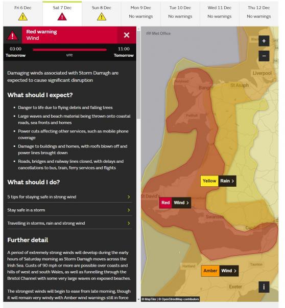
The red warning for wind covers coastal areas of south and west Wales and south-west England bordering the Bristol Channel from 3am to 11am on Saturday.
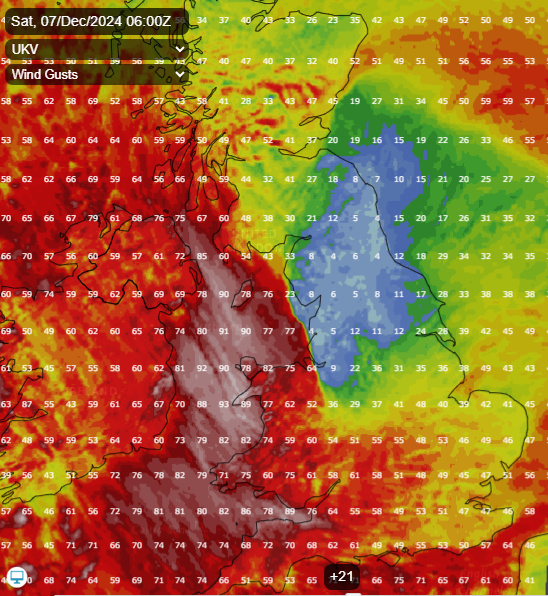
Gusts are likely to reach in excess of 90mph in places, particularly along coasts and over hills next to the Irish Sea coasts, with violent winds also funneling through the Bristol Channel - leading to danger to life, structural damage to buildings, transport disruption and power cuts. The strong winds will also cause very large waves along exposed coasts.
UKV showing gusts in excess of 90mph over the Irish Sea and surrounding coasts on Saturday morning
These strong winds will be sustained over several hours from early to late morning in these areas, before winds ease early afternoon, but still remaining very windy for the rest of the day.

An amber warning for wind has also been issued for Northern Ireland, south-west Scotland and western parts of England and Wales, valid from 1am to 9pm on Saturday. The warning is for gusts of 70-80mph around exposed coasts and headlands, 60-70mph gusts inland. Strong enough to bring trees down with a risk of disruption to transport and power supplies. A broader yellow wind warning covers most of England and Wales for wind gusts of 40-50mph possible inland, locally in excess of 60mph, perhaps 60-70mph around coasts, locally nearer 80mph. Again, this could bring fallen tree branches and travel disruption to other areas not in the amber warnings. The wind warnings in effect until 0600 on Sunday morning.
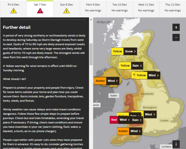
Along with the winds, heavy rain could bring areas of flooding, and hill snow in Scotland may also be disruptive, with a yellow warning for snow in force north of the central belt across the Highlands.
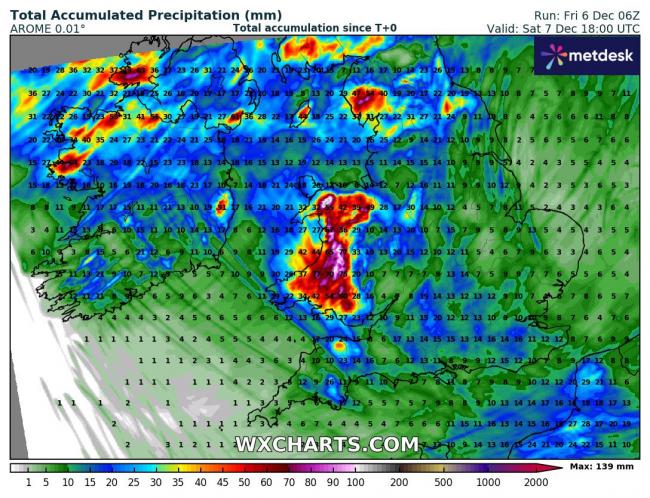
There is an amber warning for rain between 3am to 6pm on Saturday for south and mid-Wales, with up 80-90mm falling during Saturday. AROME computer models indicated there could be over 100mm over higher ground. These large rainfall totals over a short space of time falling on saturated ground, combining with recent heavy rainfall flowing into rivers that have recently brought flooding to parts of Wales and western England, could bring significant flooding concerns over the weekend and perhaps into early next week.
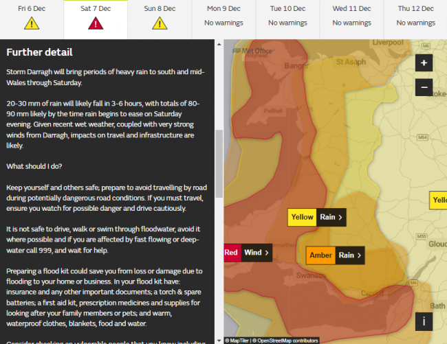
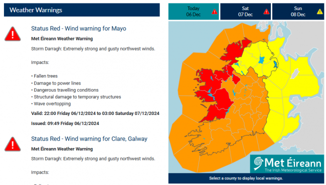
A Status Red Wind Warning has also been issued by Met Eireann for Mayo, Clare, Galway, Donegal, Leitrim, Sligo. With an amber warning for the rest of Ireland.
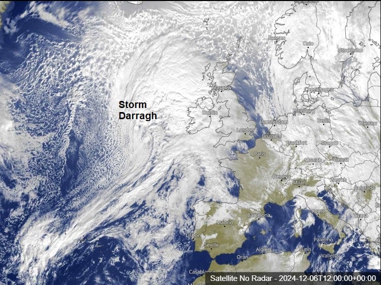
Storm Darragh low is out over the Atlantic on the approach to the west of Ireland, central pressure around 985 hPa on the T+00 fax chart for noon today, it will deepen further as the centre of the low moves across N. Ireland tonight, then across northern England Saturday morning, before exiting out over the North Sea in the afternoon, then moving southeast crossing over into the Netherlands Saturday night, the low no longer deepening, but filling.
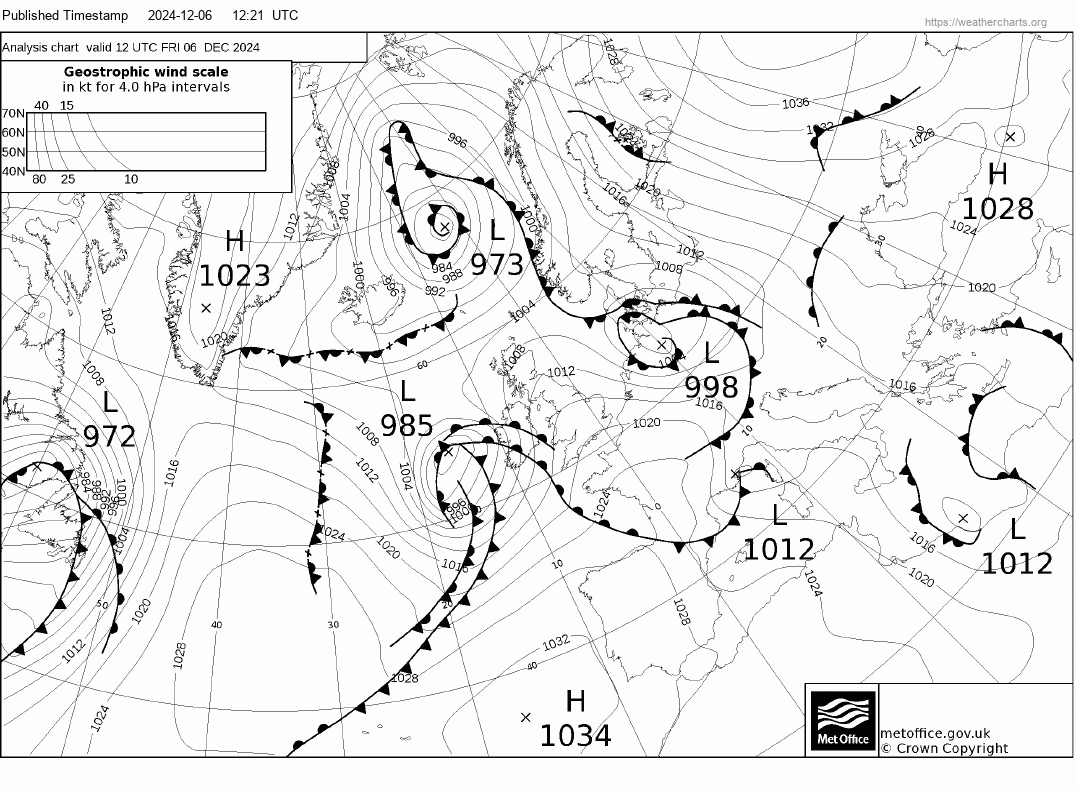
The strongest winds will be on the western side of the Storm Darragh low, where there will be the tightest pressure gradient and sudden rise in pressure, as ridge of high pressure builds rapidly to the west over the Atlantic. The strongest winds will be northwesterly veering northerly on the back of the low, with damaging gusts arriving across western Ireland later this evening, transferring across Ireland to the Irish Sea early Saturday morning, but we could see a prolonged period of up to 12 hours of damaging winds in excess of 70mph down the Irish Sea and along coasts and hills surrounding and along the Bristol Channel. So prolonged winds could weaken trees sitting in saturated ground, with a greater risk of whole trees being blown over, even without leaves now.
Although winds will ease across Wales and SW England during the afternoon, they will remain strong to gale force, with gusts of 60-70mph still possible along coasts. Strong northwesterly winds transferring further east across England through the afternoon and evening, not as strong as further west, but still could be 40-60mph gusts inland locally, 60-70mph along exposed coasts.
All-in-all, not a good time to be out and about, especially in the west, where it would be advisable not travel and stay at home, given widespread travel disruption likely, particularly in the red warning area - where people should stay at home or remain indoors for their own safety.
Loading recent activity...