High pressure is going to remain the dominant feature of the UK's weather during the coming week and probably beyond. That's going to lead to an exceptionally dry start to November.
Early November is looking set to get off to an exceptionally dry and anticyclonic start for a large majority of the UK. The ECMWF medium range model (shown above), which goes out to day 10, still has high pressure covering a large part of the country on day 10 (12 November). Some model runs, such as from the GFS, have high pressure sticking around even longer than that.
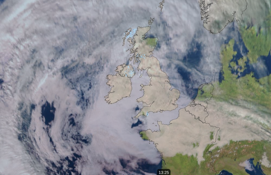
Today has got off to a cloudy start almost nationwide, with just very limited areas of the UK seeing some sunny breaks, mainly northern Scotland.

It looks probable that this will be a recurring theme during this anticyclonic spell, with plenty of what is known as “anticyclonic gloom”, with stratus and stratocumulus clouds capped by the sinking, stable air within the anticyclone and failing to shift for most of the time.
In the summer half-year, when solar radiation is relatively high, often a cloudy high such as this one will see the cloud shift from most areas during the daytime, turning it into a relatively “sunny” high. Dry but predominantly cloudy weather in summer tends to arise when high pressure is sat close to, but not on top of, the country, allowing a steady supply of moisture and cloud to head in from the surrounding seas. This is typically the North Sea if the winds are blowing from the north or the east, as happened in late August 2021, or the North Atlantic in the case of a westerly, which for example happened in late August 2008. However, at this time of year, cloud can persist for long periods with high pressure on top of the country as well.
The high pressure area is forecast to sit mostly over and to the east of Britain – again, a location that is often associated with warm or hot and sunny weather in the summer half-year, but which is likely to produce a lot of cloud during the coming fortnight. This means that winds will often be southerly, which also means that northern Scotland is likely to continue to be among the sunniest regions of the UK, with some shelter from the southerlies, particularly to the north of the Scottish Highlands, helping to break up the cloud cover.
Another feature of the forecasts is the likelihood of exceptionally low rainfall totals during the first half of November in some parts of the country. Parts of eastern England have potential to see no measurable rain at all during the first half of November, or, failing that, less than 5mm during the whole period. Parts of northern and eastern Scotland also have potential to be largely or completely dry during the first half of November. But due to the positioning of the high, we can expect a modest amount of rain to come into western Britain at times, particularly during the second week of November and particularly in Northern Ireland and western Scotland.
High pressure often translates to cold weather and frost and fog at this time of year. However, this time around, with some warm air masses and southerly winds, it is forecast to be generally warmer than average for the time of year. Generally cloudy weather will also help to prevent the temperatures from dropping substantially overnight.
It is fairly common to get high pressure dominating the weather over Britain during early November, but it is rare for the high to stick around for more than a week. The Novembers of 1987, 1988 and 1995 all started off with high pressure dominating and dry weather for most of the UK throughout the first week, but in both cases, the high moved away by the 8th, allowing low pressure systems to move in from the west. There have been no more recent examples of a completely anticyclonic first week of November, although 2004, 2006 and 2007 came close with generally dry, anticyclonic weather and just occasional weak frontal systems mainly affecting the north. Thus, there is potential for some areas of the UK to end up with their driest first half of November for many decades.
When Britain’s weather is dominated by high pressure, this necessarily means that some other parts of the world have low pressure dominating, and consequently, plenty of rain. There has recently been exceptional and catastrophic flooding in and around Valencia in eastern Spain.
Normally the Valencia area has a dry climate, with less than 500mm of precipitation per year, making it one of the driest parts of Europe, although October is often the wettest month of the year there. However, locally over 600mm (over a year’s worth!) of rain has fallen in less than a day, with close to 500mm in just eight hours. The estimated death toll has recently risen to over 200.
While it will not be relentlessly wet around Valencia during the next ten days or so, there is potential for further substantial rainfall thanks to persistent easterly winds bringing moisture in off the Mediterranean Sea, on the southern flank of the high pressure area that is proving hard to shift from the British Isles and the North Sea. Forecast models are generally suggesting 30 to 50mm of further rain in the region in the next 10 days, which is far from unusual for this time of the year. However, it will nonetheless be likely to hinder the efforts to clean up following the recent floods.
Loading recent activity...