A complex weather pattern across the UK this weekend, with showers and thunderstorms for England and Wales contrasting sharply with drier conditions in Scotland and Northern Ireland. Meanwhile, central Europe grapples with the aftermath of severe flooding, with the potential for further rainfall in the region.
Showers and thunderstorms will be a significant feature of the weekend over much of England and Wales, while for many today will be the warmest day of the recent high pressure spell, peaking at 25 or 26C in places.
For Scotland and Northern Ireland and the far north of England, it will be a generally dry weekend but with a marked west-east split in sunshine amounts. Easterly winds have been bringing a lot of cloud in off the North Sea into eastern regions, resulting in relatively cool and cloudy weather by day, and warm nights, as the cloud cover traps heat near the surface overnight. For much of western Scotland, sheltered from the North Sea cloud, there will be plenty of warm sunshine. The North Sea cloud will tend to push away from eastern England as the easterly winds slacken off in England and Wales, but there will be broken cloud cover associated with the showers and thunderstorms.
There is considerable disagreement between the forecast models regarding which regions will see showers and thunderstorms today, even at less than 24 hours out. In particular, this morning's (06Z) run from the American GFS model has showers and possible thunderstorms breaking out widely through the English Midlands and north-east Wales during the afternoon and evening. But the UKV model gives only isolated showers breaking out in England, with the majority of the showery activity confined to Wales. The ECMWF model is somewhere in between, forecasting plenty of showers and possible thunderstorms in Wales and extending into the West Midlands but with the East Midlands missing them.
A thunderstorm watch has been issued for today:
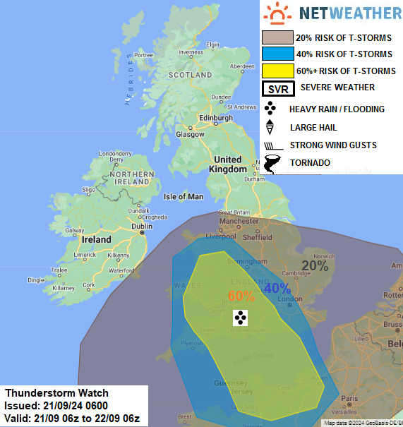
There is more agreement between the models regarding tomorrow's rain, which will mainly affect the South Midlands and central Wales southwards, with mainly showery bursts of rain and potential for thunder but they may merge into longer outbreaks of rain at times. Overall, it looks probable that while the most persistent rain will be over west Wales, the highest rainfall totals will probably be concentrated over the West Midlands, with potential for some areas to see over a month's worth of rain this weekend. This means that there is potential for problems with flooding, particularly through east Wales as well as the West Midlands, with high rainfall totals affecting quite a large area, though it is unlikely to be anything like as severe as what much of central and eastern Europe has seen recently.
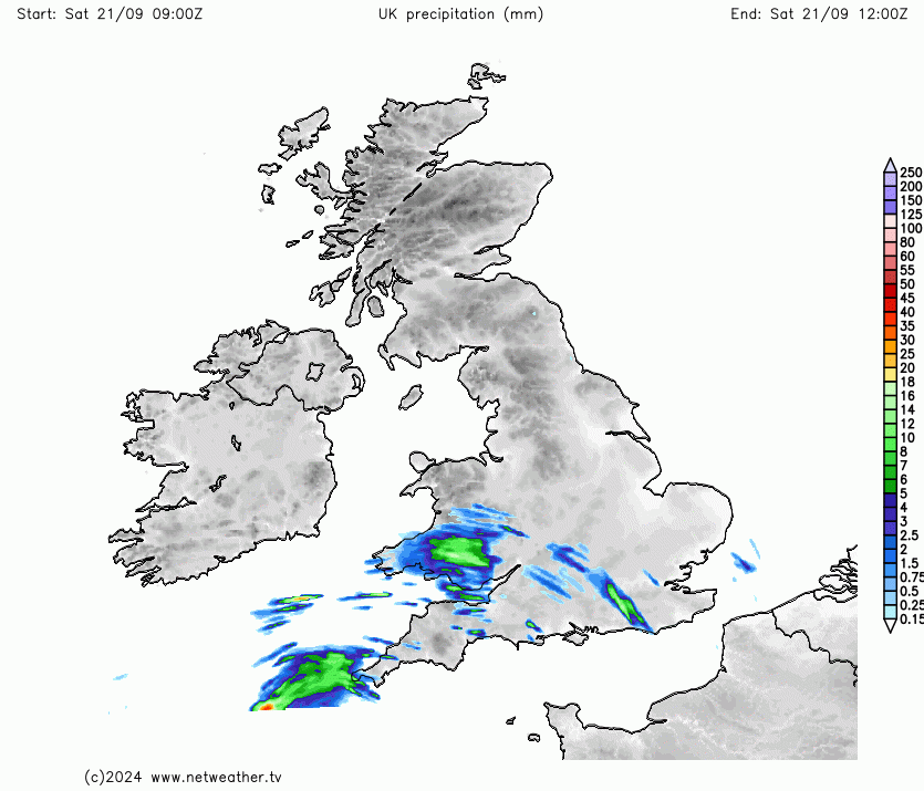 Rainfall accumulation animation across the weekend
With September 2024 having got off to a warm start and having seen a notably cold northerly outbreak in the second week, it is thus looking probable that this September will go down in history as a month with some notably marked temperature fluctuations and contrasting warm and cold spells.
The persistent and heavy rain over central Europe during last weekend and early last week has caused considerable problems with flooding and it is estimated so far that 26 people have died as a result. The floods especially affected Czechia, Austria, Italy, Poland, Romania, Slovakia, Hungary, Croatia and Serbia, and parts of Germany were also affected. This event is also estimated to have caused over $1.1 billion in economic damages.
It was caused by a slow-moving low, associated with fronts and high rainfall and humidity that was named as Storm Boris by the Italian Servizio Meteorologico. The low pressure system drew in warm air from the Mediterranean Sea which mixed with cold air coming down from the north on its western flank. It was also trapped in between two blocking anticyclones, holding it in place for several days.
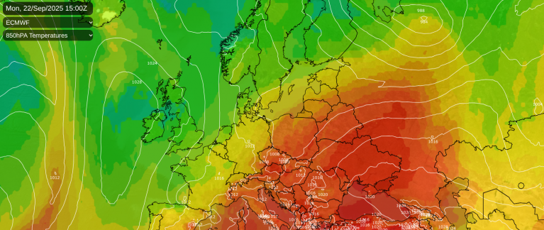
At present the cleanup is happening with predominantly dry weather over these regions providing some relief. However, there is potential for these areas to see some more substantial rainfall late next week as a southerly tracking jet stream takes hold, with frontal systems moving through central Europe from the North Atlantic, at around the same time as Britain is forecast to see a cold outbreak of northerly winds to the north of these systems. While this rain is unlikely to be anything like as persistent as what these regions saw from Storm Boris, it has potential to be quite substantial by most standards and to exacerbate the problems with flooding. For now, however, these regions are forecast to stay predominantly dry until this coming Monday.
Loading recent activity...