The weather models have been struggling to predict the evolving weather patterns more than 5 days in advance over recent days, this often happens when upper trough disruption takes place over northwest Europe, as has happened recently and is set to occur again over the next few days.
Recently, some weather models have been in stark disagreement even at just 4 days lead time, over where to position upper lows over Europe, upper features tend to more accurately modelled in the 5-7 day timeframe than surface features. For example, on Sunday 1st, the 12z ECMWF run for noon this Friday, just 5 days ahead, was showing an upper low over the southern North Sea - while the 18z GFS run for the same time was showing an upper low over Iberia!
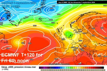
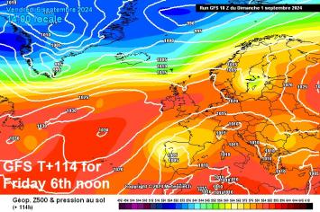
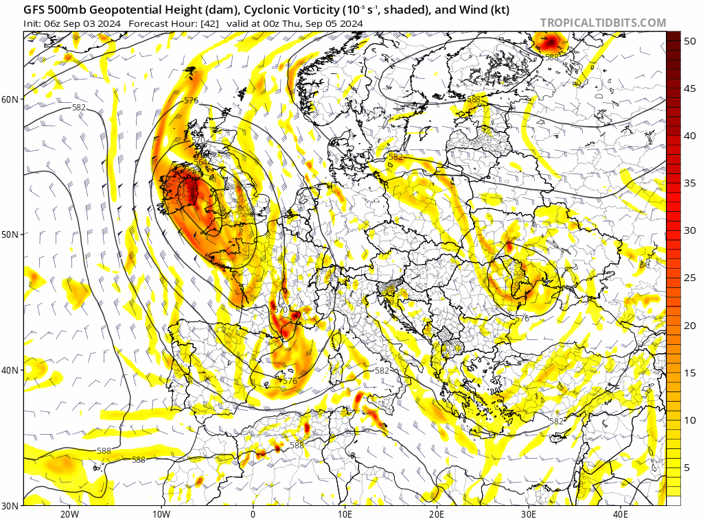
The upper low in the two charts above has formed from trough disruption, where an upper trough extending southeast over the North Atlantic from Greenland/Iceland area gets 'squeezed' on both sides by upper level highs as it continues to extend. This causes it form a cut-off upper low form, which breaks away from the main upper trough and stronger upper flow / jet stream, with a ridge of high pressure then building to the north. This can been seen in action over the next few days in the sequence below:
![]()
This cut-off upper low that forms over the UK over the next few days and drops southwest over the Bay of Biscay is going to be a bit of nuisance for southern areas of Britain from mid-week and through to early next week, as it looks to loiter, before eventually drifting east into early next week.
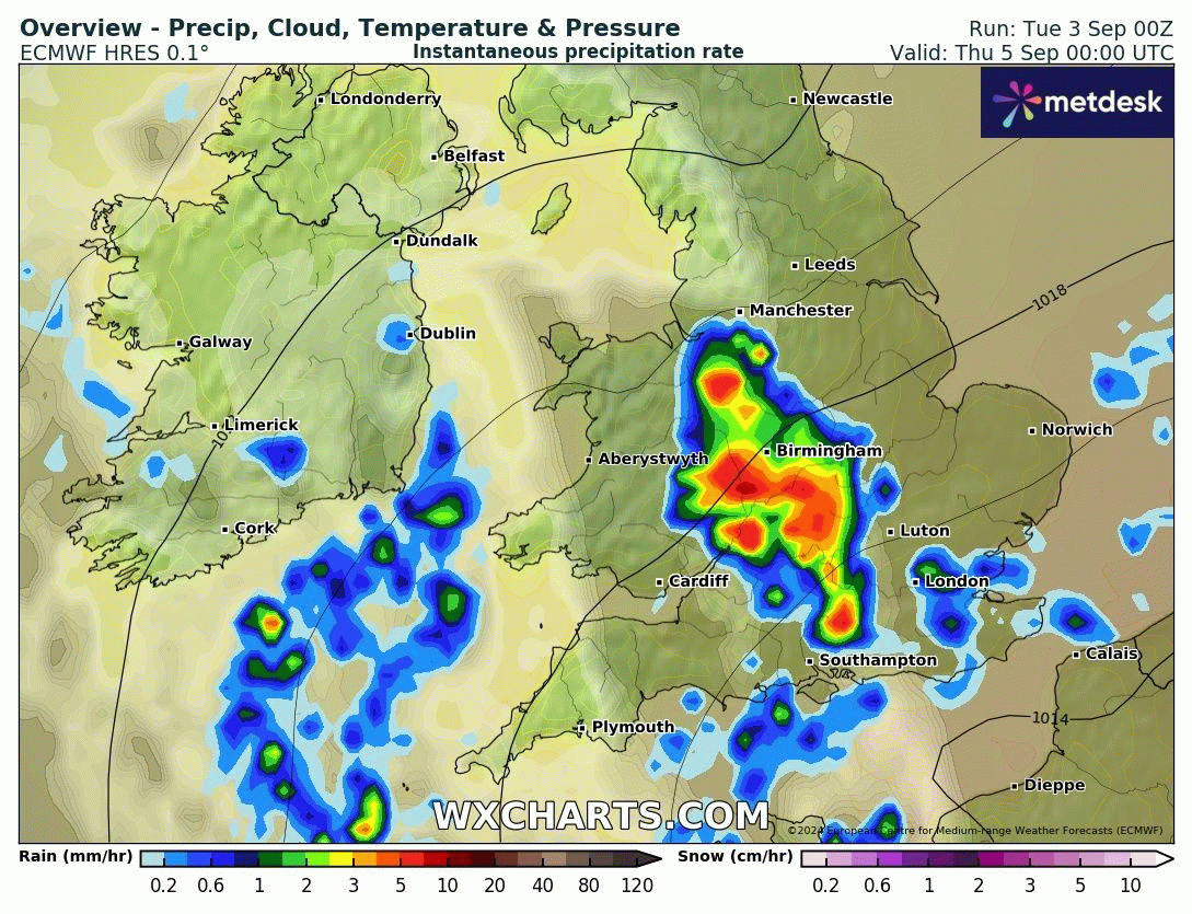
The upper low will bring colder air in the mid-levels, while a surface low pressure over France will aid in pulling warm and moist air lower down west from the Low Countries across the UK. This contrast in warmer air towards the surface and cold air in the mid-levels will create what's technically referred to as 'differential thermal advection' - this tends to lead to unstable atmosphere leading to convection with heavy showers or thunderstorms forming. Also slow-moving fronts are likely to wrap around the surface low over France moving in across southern England from later tomorrow and through to the end of the week at least, bringing more orgainsed areas of rainfall, as the front creates lift of warm moist air at the surface.
So from later on Wednesday and through to the end of the week and likely through the weekend, we are likely to see a combination of scattered heavy thundery showers from instability but also areas of more organised rain, locally heavy, developing along frontal zones that form along the boundary between cooler air trying wrap in from the southwest around the upper low and warm / moist air being dragged in from the east on the northeast side of low pressure over France.
However, there is a great deal of uncertainty between model output and runs of each model on the finer details of timing and distribution of showers and longer spells of rain - with rainfall amounts varying spatially over fairly short distances.
The Met Office have issued a yellow warning for rain for SE Wales, much of southern England, south Midlands and much of East Anglia in force between 21:00 on Wednesday to 09:00 on Thursday, They predict heavy showers or longer spells of rain, perhaps thundery, bringing 20-40mm in an hour or two.
Heavy showers or longer spells of rain look to ease west across these areas Thursday afternoon and evening, as the upper low close to SW England moves away towards the Bay of Biscay. However, further pulses of heavy rain look to return from the south across the southern half of England and south Wales during Friday, as areas of enhanced vorticity spinning around the upper low to the southwest lift north over France and engage / create forced ascent of warm and moist air advection west from the near continent across the UK.
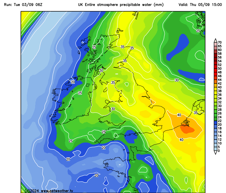
Again, the rain could be locally heavy, perhaps torrential, 06z GFS is showing a tongue of PWAT (precipitable water) of >40mm moving in across SE England on Friday. So we may see some localised issues of flooding develop - where these heavy downpours develop.
And following Friday's heavy rain clearing away west from England and Wales, further heavy rain and perhaps thunderstorms could spread up from France later in the day, as the upper low to the southwest to end the week starts to move northeast over northern France during the day. A great deal of uncertainty over timings, amounts of and extent of rainfall by the weekend. But shows could linger over southern Britain on Sunday, before the low over northern France finally pulls away.
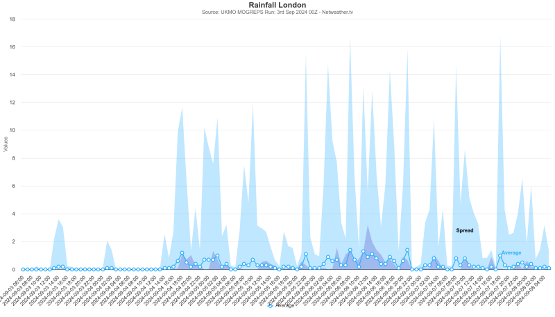
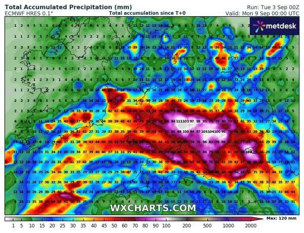
To give an idea of the wet weather on the way Wednesday night to Sunday, here some of the accumulated rainfall totals from different weather models
MOGREPS for London:
Rainfall accumulations from GFS and ECMWF through to Monday:

Loading recent activity...