The late August bank holiday weather looks set to be typically changeable, but a brief hot spell is on the cards for midweek. Early September has potential for more warmth, bearing some similarities to September 2023.
The late August bank holiday weather in England, Wales and Northern Ireland (it is not a bank holiday in Scotland) is usually changeable, with westerly winds and low pressure systems moving from west to east. It is a time of year when autumn is fast approaching, and we are prone to seeing remnants of tropical hurricanes merge with extratropical lows moving across the North Atlantic. This weekend is set to be no exception, although it looks probable that much of the eastern half of England will become warm and sunny on the Bank Holiday Monday, with temperatures in the low to mid-20s Celsius.
It isn't always this way, and just five years ago, in 2019, we saw a new record high temperature for the late August bank holiday of 33.2C at Heathrow Airport in London, and it also reached 33.3C at Heathrow on the Sunday. Much of the country was warm or hot and sunny for much of the weekend. Previously, the hottest Bank Holiday weekend temperature on record had been 31.5C, also at Heathrow, in 2001, followed by some substantial thunderstorms in the south-east, but the Monday itself had never seen a high of 30C or above. Late August 2021 had high pressure covering most of the UK, and parts of western and northern Britain had a lot of dry, sunny weather, but most of eastern England had a lot of cloud and cool temperatures via a north-easterly flow bringing cloud off the North Sea.
It looks fair to say that those sorts of temperatures will not be challenged during the late August bank holiday of 2024, although as noted above, the Monday looks set to be warmer than of late for some.
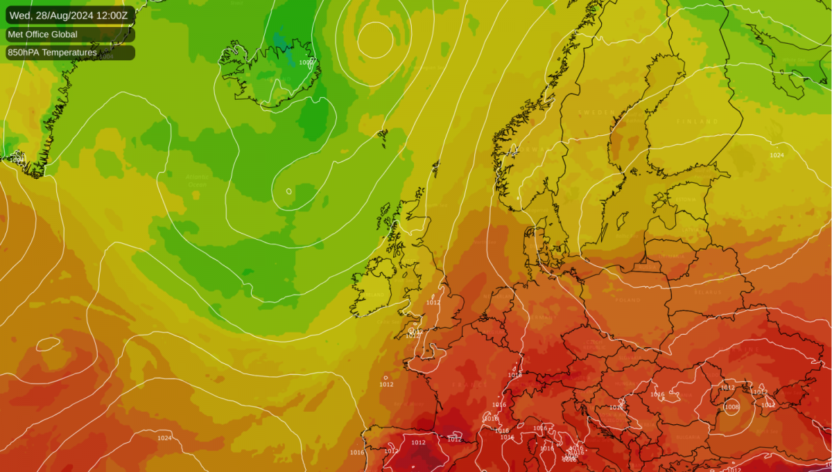
The warmer weather on the bank holiday Monday will mark the beginning of a brief hot spell next week as we will import some hot air masses from the south, which will again especially affect the eastern half of England. It looks probable that the hottest locations will reach around 30C on Wednesday, with potential for a 31 or 32C high locally, which is notable for the end of August, although it looks unlikely to produce the hottest day of the year for the UK, as Cambridge recorded 34.8C on 12 August 2024.
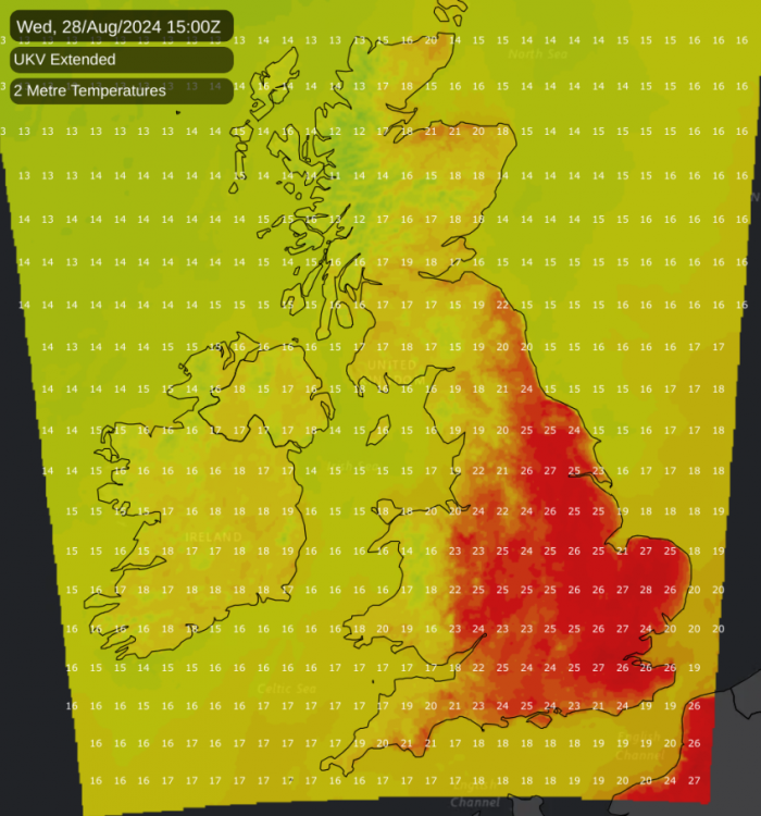
Overnight Tuesday/Wednesday and especially Wednesday/Thursday is forecast to be warm for most of England in particular, creating difficulty sleeping for many of us. There is also potential for a thundery breakdown for some, especially on Thursday, which has potential to be another hot day for eastern England, before cooler air spreads in from the west to affect all of us by Friday.
Early September 2023 had an exceptional heatwave for the time of year, with a high of 33.5C at Faversham (Kent), which unusually meant that the hottest day of 2023 fell in September. Generally, the majority of July and August 2023 was unsettled and rather cool for recent years, with a particularly wet July for most, with hot and sunny weather concentrated in June and September, both of which were record warm months for the UK. As well as hot days, in the September heatwave, warm nights were an issue for many of us, creating difficulty sleeping at night and issues especially for the elderly and vulnerable, particularly as the hot weather persisted for over a week. Northern Ireland also recorded a national temperature record for September with 28.0C at Castlederg (County Tyrone) on the 8th. At the end of the heatwave, some of us saw noteworthy thunderstorms around the 10th and 11th.
Early September 2024 has potential to be another hot one, with forecast models suggesting a high chance of high pressure building from the south into the beginning of September, also bringing warm south to south-westerlies to north-western Britain, and continental air into the south. Thus, it looks probable that the cooler weather that is forecast for next Friday will only be temporary. As well as a likelihood of high pressure being close by, producing plenty of dry and sunny weather for many, temperatures are also forecast to be above normal, especially towards the south-east. While it is unlikely that we will see a heatwave in early September 2024 that is quite as intense or prolonged as at the same time in 2023, at present it cannot be completely ruled out, as the prevailing weather patterns look set to be quite similar to what we saw last year.
Loading recent activity...