With just a few weeks left of meteorological summer, it is perhaps prudent to start looking ahead at what autumn may in store weatherwise. The seasonal models have recently updated, so we will start with these to get an idea on how autumn may pan out. I will also look at analog years that had a similar ENSO (El Nino Southern Oscillation) pattern going into the autumn. According to the US Climate Prediction Center - ENSO neutral conditions are expected to continue, with La Nina favoured to emerge during autumn (with 66% chance) and persist through the Northern Hemisphere winter 2024-25 (74% chance during November-January). Though there is no guarantee that La Nina will form, with potential for neutral conditions persisting through autumn and into winter instead.
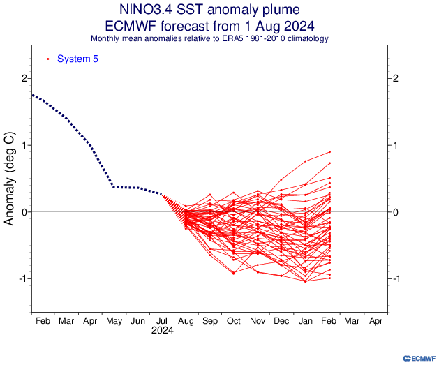
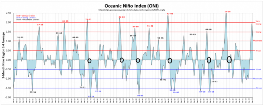
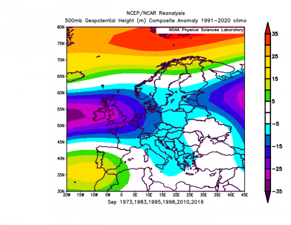
For years with a similar neutral to La Nina transition we can use previous years (analogs) where similar Oceanic Nino Index (ONI) decreases were noted between the summer and the upcoming autumn. 1998 is a strong analog year: going from a strong El Nino to strong La Nina in the same year, the Nino last winter was very strong/strong. We can add 2016, 2010, 1995 for transition from neutral in summer to Nina in autumns too. We may use years prior to the 1990s too, but to problem is going too far back is that global warming has increasingly skewed atmospheric circulations, making analogs less useful. But prior to the 1990s, 1983 and 1973 are good analog years of a transition from neutral to La Nina.
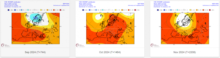
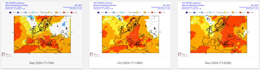
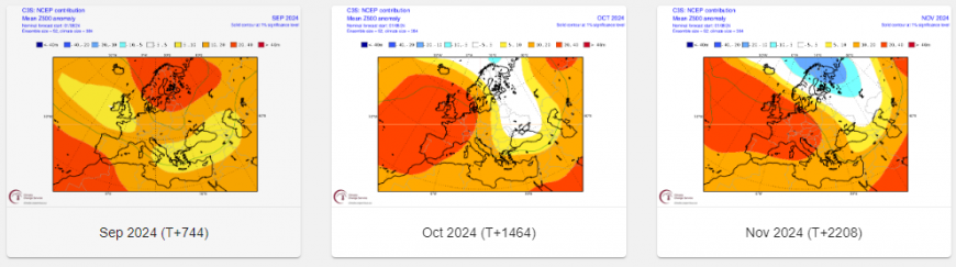
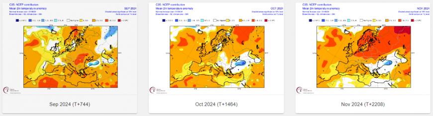
A selection of the seasonal model output - August updates from ECMWF and NCEP:
EC 500 hPa and temperatures for each autumn month
NCEP 500 hPa and temperatures
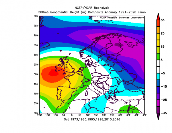
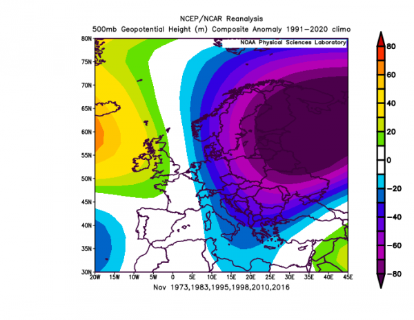
500 hPa height analog composites for each month of autumn based on ENSO phase this summer and likely transition into autumn:
September
October
November
Indications from ECMWF 46 day model run, seasonal models and the analog years composite are for the UK and Ireland to be mainly be under the influence of upper troughing over the North Atlantic extending east which will bring recurring depressions moving east between Ireland and the Baltic Sea, therefore often under cloudy and humid weather in most regions, with spells of rain moving through, rainfall tending to highest in the north and west, drier in the east of England. Often the flow looks to be from the west or occasionally from the southwest, so probability for temperatures more likely to be generally around average.
A mixed signal from the seasonal model output for pressure amomalies, although general theme is for pressure to be lower over northern and northeastern Europe higher towards the south and southwest. However, the NCEP seasonal 500 hpa chart for October and the analog years composite looks very similar in having North Atlantic high pressure anomaly close to the southwest of UK - so we may see drier settled periods-especially in the south and west, if this occurs early in the month, it could be rather warm for the time of year. But there could also be changeable periods for all parts as low pressure influence takes over. It appears average rainfall overall most likely for the UK, though perhaps drier than average anomaly may occur in the southwest, wetter than average in the far north. Temperatures around 1C above thanks to high pressure at times, especially if early in the month.
There is a fairly strong signal from some seasonal models, given the range, ECMWF and NCEP in particular, but also from the analog years composite, for there to be a low pressure / heights anomaly to the northeast over towards NE Europe in November in the mean, with high pressure / heights over western Europe / North Atlantic. This would imply cool or cold weather at times, with winds from the north or northwest, changeable conditions for all at times, but with a tendency for wettest conditions in the north and east. As a result, temperatures ending up average at best, but a chance too of November being below average - given the signal.
So in conclusion, September could be quite an unsettled, cloudy but humid month with average rainfall and temperatures. October could see a greater chance than normal for some settled and dry weather, if this is early in the month, it could be quite warm for October, bringing the monthly temperature above average. Some unsettled weather also likely, as is the norm. November most likely changeable, as is the norm, but a signal for cool or colder conditions from the north or northwest at times.
A full Netweather autumn forecast will be issued at the end of this month, this will provide a more in depth analysis of not just what the seasonal weather models and the analog composites show, but also looking at other drivers that may influence the weather through autumn. So, thoughts on each month may change from these early thoughts in this article.
Loading recent activity...