Following a July characterised by contrasting weather patterns, the UK is now set for a persistent northwest-southeast divide with lower pressure to the north and west.
July 2024 for most of us was a "month of two halves". The first half was unusually cool for recent years, unusually cloudy, and also wet in most areas of the country, especially eastern England. However, the second half was generally warmer and sunnier, and for many areas of the UK, particularly the south and east of England, it was generally dry.
Reflecting our changing climate, the warmer second half was sufficient to raise the month's mean temperature slightly above the old 1961-1990 average in most regions, particularly eastern Britain, but they remained just below the more recent 1991-2020 long-term average. Some southern and eastern areas, especially the south of England, came out wetter than average overall due to the wet first half, but in the west and especially south-west of Scotland it was quite a dry month.
As in many recent months, thundery activity was generally below normal during July, with the rain of the first half tending to consist mainly of bands of cloud and persistent steady rain via frontal systems, rather than short, sharp showers and thunderstorms, and then a dry second half. May 2024 had relatively widespread thundery activity, although even then, some of the traditionally thunder-prone regions of eastern England missed out, while June also had relatively few thunderstorms for most.
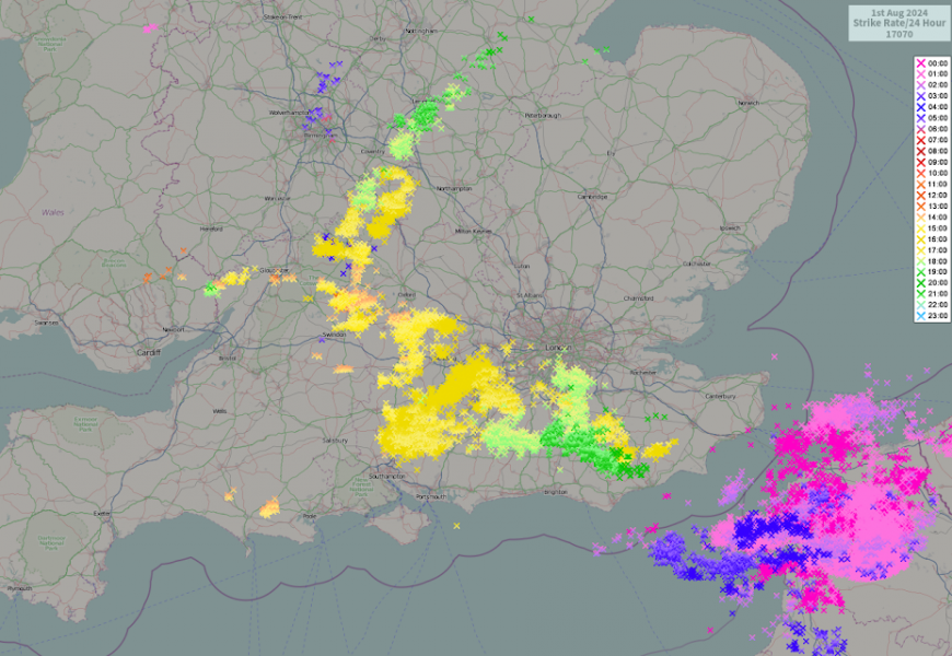
Into the beginning of August, some places had significant thundery activity on 1 August, with just over 17,000 lightning strikes recorded by the Netweather lightning detection system (powered by Vaisala), but it was mostly a case of intense thunderstorms affecting a relatively small area. The main affected area was a line running east-south-east from Swindon across to the south of London, extending as far east as Sussex, and some relatively modest thunderstorms also pushed north-eastwards into south Lincolnshire. These storms triggered flooding in parts of the south.
For the next week to 10 days, once again heavy showers and thunderstorms are not set to feature very often. We are looking at a northwest-southeast split in the weather, with all parts of the country having a changeable west to south-westerly type, but there is high confidence in rainfall amounts being small in the east and south-east of England, particularly from Suffolk and Cambridgeshire southwards. In contrast, it looks set to be frequently wet in west Wales, Cumbria, western Scotland and Northern Ireland.
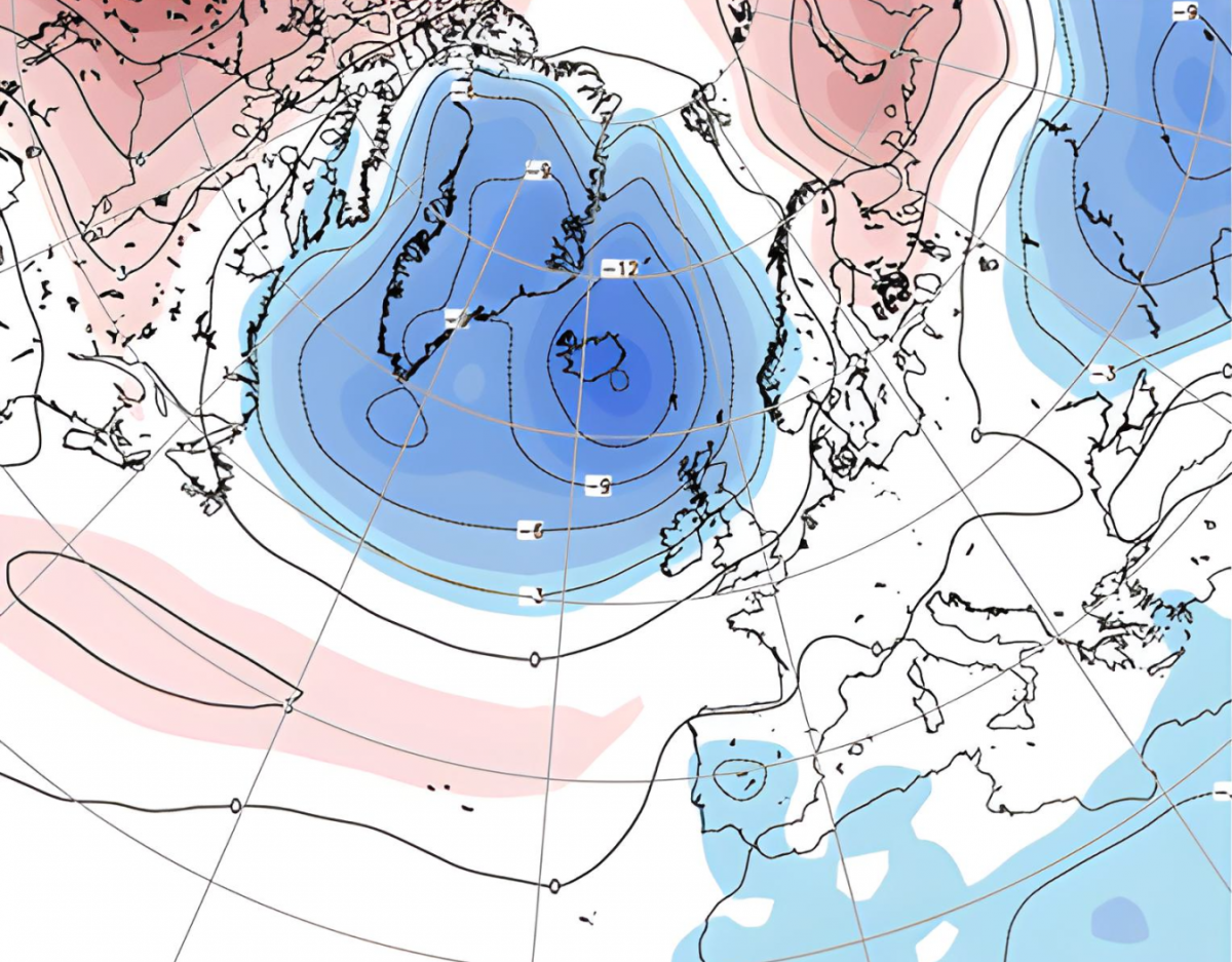
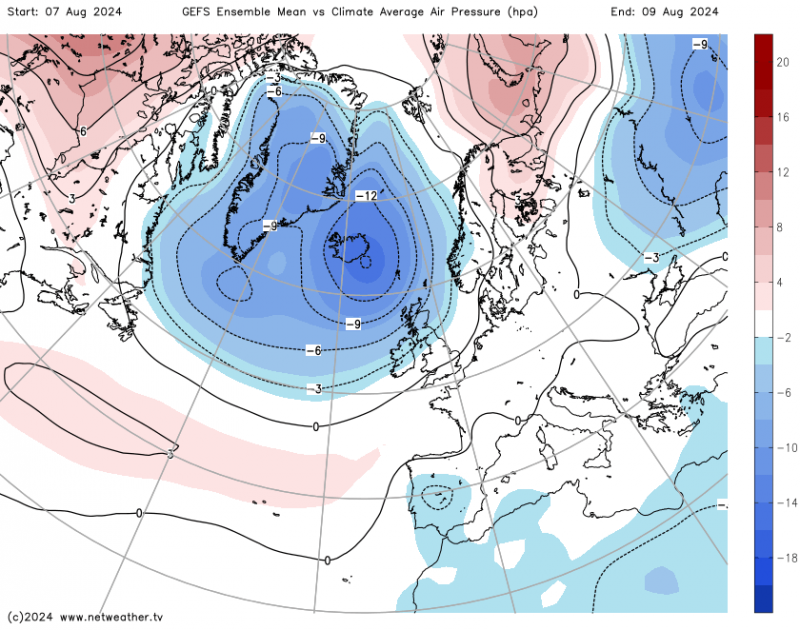
This pattern is being caused by a persistent low pressure area over Iceland and high pressure ridging from the Azores through France and Germany, keeping high pressure close to the south-east of Britain.
Temperatures will mostly be close to the long-term average for the time of year, but Monday is set to be hot in eastern England with a region extending from East Anglia to Yorkshire forecast to have highs in the high 20s Celsius and maybe around 30C locally.
After the 7 day mark there is, however, considerable divergence between the GFS and ECMWF medium-range forecast models. Some model predictions, particularly from the ECMWF is suggesting a continuation of the upcoming pattern through to the middle part of August, perhaps with a shift to cooler weather and more rain for the south-east from around 20 August.
Others, notably by the GFS model, have consistently been sending the jet stream further south as it heads into Europe, resulting in pressure falling to the south and south-east of Britain and low pressure systems regularly crossing the country, which would result in cooler, wetter, more unsettled weather for the south-east, but it would probably turn drier in north-west Scotland.
So, we can be reasonably confident that the northwest-southeast split pattern will persist for at least the coming week, but there is considerable uncertainty over whether the pattern will persist much beyond that. There is strong agreement among the forecast models that high pressure and allied warm/hot and sunny weather will not extend northwards for any sustained periods, however, which means that it is very likely to remain wet in western Scotland, Northern Ireland and parts of west Wales and north-west England for the foreseeable future.
Substantial heat looks set to be largely confined to southern Europe, where it is expected to be bottled up and to become intense at times, particularly in Spain where temperatures in the low 40s Celsius are forecast to feature on most days during the coming week, especially in inland parts of southern Spain.
Loading recent activity...