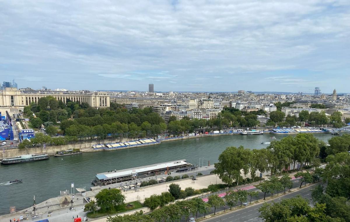
Summer heat would always have been a concern for Olympic organisers when considering Olympian and visitor well-being. Especially after the intense heat and humidity at Tokyo 2020. A different type of weather has caused a postponement today. After the deluge of heavy rain that the world witnessed for the Paris opening ceremony, the Triathlon has been impacted due to water pollution in the Seine. The threat of evening thunderstorms could bring further intense downpours.
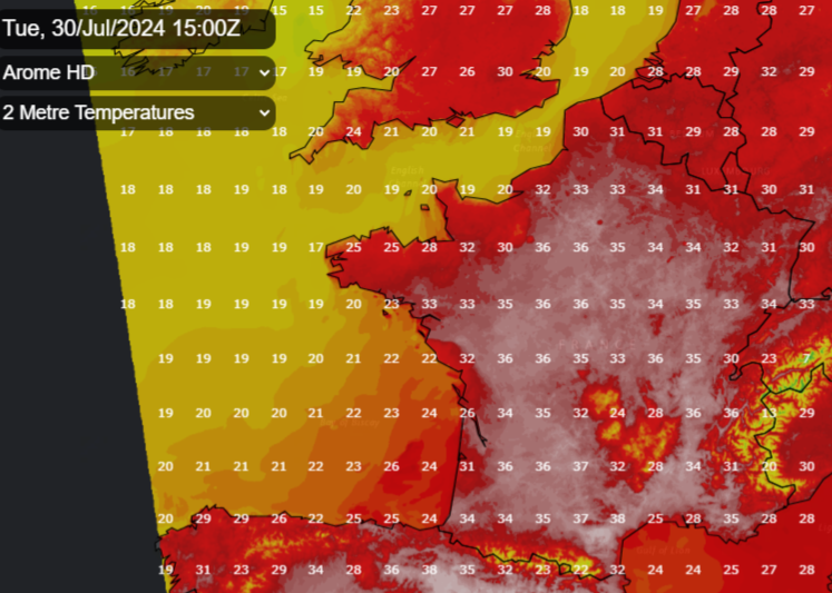
 Thunderstorm threat for Tuesday evening in the Paris region. Arome model
The Olympic male triathletes were up early on Tuesday 30th but were greeted with the disappointing news that their event had been postponed because of poor water quality in the Seine. The Men’s individual triathlon has been moved to Wednesday, now scheduled after the Women’s event. Training sessions had already been cancelled in the river after the heavy rain that soaked the start of the Games. As we often see here in the UK, heavy and persistent rain leads to unsafe bathing waters in the following few days.
There has been much investment in recent years to clean up the Seine but even with large storage facilities for rainwater, the city’s underground drains and sewage system was overwhelmed. Paris has had a wet spring and start to summer, stuck beneath a more southerly jetstream. This has brought unsettled weather to the UK but also heavy and thundery weather again and again to northern France and the Low Countries. There were existing worries about the water quality for these events, with reserve days and flexibility in the scheduling. For the athletes, this late change will be most unnerving and the forecast now includes the risk of thunderstorms. Any storms may miss Paris and the Seine’s catchment but if there is more heavy rain, that will only add to the ongoing water quality issues.
The rain on Friday and Saturday impacted Skateboarding, the outside courts of the Tennis and cyclists slid off their bikes in the time trials. Olympians and spectators may be hoping for more fine weather and the storms to stay away but if the water pollution continues there is an option of dispensing with the swimming part and changing the Triathlon event to a Duathlon.
‘Predominantly anticyclonic situation over the country with advection of very hot air. The heatwave which began on Sunday in the south will extend towards the north.’ Meteo France
Heat and Thunderstorm risk
Paris has two weather warnings on Tuesday for heat and the risk of thunderstorms later in the day. By Wednesday much of southern and central France has an amber heat warning. Temperatures inland in the south tipped over 40C on Monday.
For Paris, Tuesday looks to be the hottest day of the week (the same heat in the UK where we could see 32C) with very high UV values. Tuesday, 35C with a small chance of evening thunderstorms but feeling more like 38C. It will be warm overnight, barely dipping below 24C in the French capital. The men's football is underway with matches in the south of France where temperatures will be over 30C with Spain v Egypt looking hot in Bordeaux this afternoon.
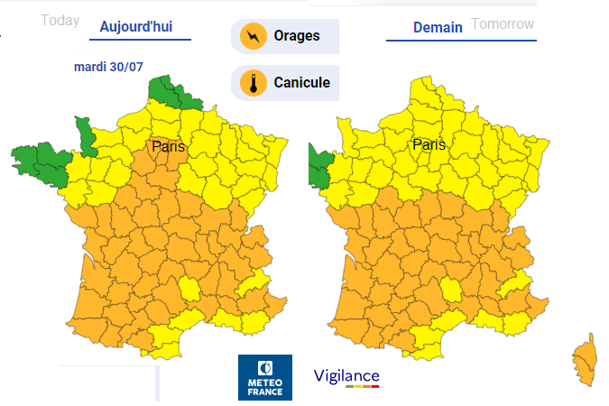
There is an amber thunderstorm warning including Paris this evening into Tuesday night. There is a low risk for Paris but the possibility of very high impacts if a storm arrived. A thunderstorm could bring more heavy rain, lightning, hail and gusty winds.
“The unorganized nature of convection makes the predictability of the location of storms very low. The potential for storms is nevertheless present throughout the region.”
Wednesday starts off fine but will see more cloud early afternoon and perhaps a few showers. It will be hotter by the evening, up to 32C but feeling more like 35C.
Thursday sees a higher risk of thunderstorms, even first thing in the morning. These same early pulses could bring rain to SE/E England on Thursday morning. The detail has low confidence at the moment for Paris but storms could cause interruptions to events during the day. The UK also has thunderstorms warnings, starting on Wednesday in southern England and the Channel Islands for isolated storms and the risk of surface-based thunderstorms for inland southern Britain Thursday pm.
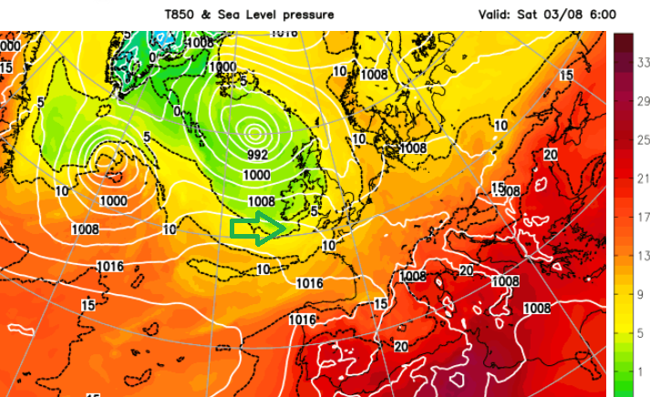
A change from the humid heat is on the way for the weekend with fresher nights and temperatures peaking at a more comfortable 27C. A large Atlantic low pressure will move north of Scotland and allow a different airflow to move over the UK and northern France.
Surfing
“The waves at Teahupo’o will offer an Olympic-class challenge for the athletes, and treat fans in Tahiti and around the world to a breathtaking experience. Tahiti will host a one-of-a-kind competition in a location that surfers the world over revere.” Paris Olympics
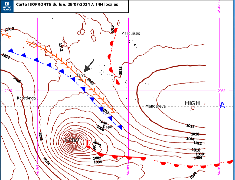
A pacific storm has interrupted the Olympic surfing which is being held on the other side of the world in French Polynesia. Tahitian waves by the small village of Teahupo'o are the setting for the 2024 surfing but a strong swell and onshore wind have led to a delay on Monday 30th. “SURFING TENDENCIES FOR 30/07/2024 – RED: The competition is OFF tomorrow 30/07/2024 7:00am GMT-10”. This impacts the Quarter Final heats for the men and women on Tuesday but there are plenty of reserve days available into the weekend.
Meteo France covers the forecasts in this region ‘A depression is circulating to the south of French Polynesia generating a fairly strong wind as well as a strong South-West swell.’
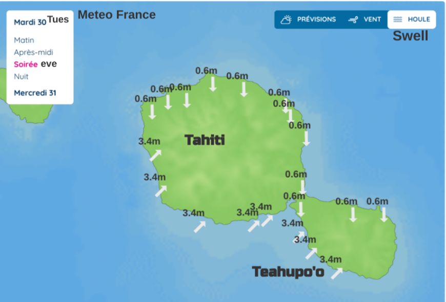
Temperatures range from 20C by night up to 29 Celsius by day, moderate to locally fairly strong SW onshore wind with gusts of 55 to 65km/h (40mph). Heavy seas. Long southwest swell from 3-3.50m.
On Wednesday, it backs to a moderate SSE (30km/h 18mph) with gusts along the coast of 50km/h 30mph Wednesday looks dry and bright. Outlook wind going round to the east with a 0.4m northerly swell.
Loading recent activity...