Another mixed week with temperatures in the high teens and low 20sC. There will be times of persistent rain which give way to drier, brighter times followed by showers. The heat remains in S/SE Europe.
The week ahead will see more rain and showers. Overall the air is still feeling fresh, so it will be cool in the north by night but feeling warm in the strong July sunshine. Warmer air should brush SE Britain on Tuesday as France and the Low Countries see heat and a risk of thunderstorms. Overall the UK temperatures will be in the high teens to low 20sC, perhaps reaching 24C for a few southern cities in England.
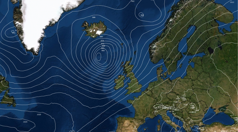
There are distinct areas of rain forecast for this week as low pressures move by, with heavy bursts embedded. If you are trying to plan outdoor activities, if you are already on school holidays or hosting sports day or a fete, here’s a look at the week ahead.
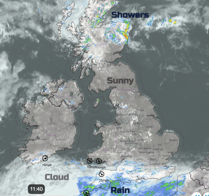 Netweather radar Monday 8th July as southern rain sets in.
Monday
For much of the UK, it has been a sunny, fine Monday morning even after a cool start. Northeast and west coast Scotland has seen more cloud and showers and there will be a scattering of showers for northern Britain and Northern Ireland this afternoon but still with plenty of bright spells. A different story for southern England with increasing cloud, patchy outbreaks of rain and an incoming low pressure which will bring heavier rain later today. There is a Met Office yellow Rain warning into Tuesday for the West Country across to the Isle of Wight and over southern Wales. The low will then move over the UK bringing more heavy rain and heads to Scandinavia by Thursday.

The rain moves from Cornwall and Devon early evening and spreads over southern Britain tonight. There will be heavy downpours in this with a freshening east veering southerly wind. Northern parts stay drier, cool with light winds.

Tuesday
There will be the main band of rain across a central swathe of the UK in a cool easterly wind. This will edge northwards during the day. It will feel quite miserable for northern England, Northern Ireland (particularly eastern counties) southern Scotland and the Central Belt with wind and rain. In the southerly flow, to the south of the rainband, it will feel quite warm. Where any sunny spells appear, it will feel warmer. Here a few showers will break out with the risk of sharp, even thundery downpours. The main action is forecast to be over northern France, Belgium and the Netherlands by Tuesday evening.

Across the UK on Tuesday night there will be clusters of heavy showers edging northeastwards and the main rainband will continue spreading northwards. The whole showery low will rotate over Northern Ireland and Scotland

Wednesday
The wettest weather looks to settle over northern mainland Scotland, particularly the northeastern, by Wednesday morning. The persistent and heavy rain will bring the risk of localised flooding. There will be plenty of lingering cloud and damp weather for Northern Ireland and reaching NW ENlgnad in a brisk north to NW wind. Over southeastern Britain it will still be warmer with good sunny spells but also heavy showers with the risk of thunder. Temperatures for inland England should be around 20 to 23C with 24C possible for Norwich.

Thursday
Thursday morning brings dry and bright weather to much of southern Britain as the fading remnants of cloud and rain further north drift around the Irish Sea and over central Britain. Southeast Britain will be the warmest area with temperatures in the high teens and low twenties.
Another low pressure will run in from the Atlantic towards the English Channel. There is some uncertainty about its path for later on Thursday. Will there be heavier, showery downpours or will most miss southern England and just affect northern France?

Outlook
Friday and Saturday look mixed, with more brightness. It will feel warm in any sunny spells but there will be more showers and temperatures struggling, just into the high teens.

There are heatwave warnings for the Balkans, Austria and Hungary, a red warning of heat in Croatia and high temperatures forecast for Sicily, Sardinia and western Greece on Tuesday. Germany will be warm for the semi finals of the Euros. Spain versus France in Munich (in the south) it looks very warm by day, up to 30C. For England‘s match v. the Netherlands (in the west) the maximum temperature could be 27C but maybe slightly lower by 8pm.
Loading recent activity...