It has been hot and humid this week, mainly for England and Wales with temperatures in the mid to high 20sC. Surrey has seen temperatures reach 30C for the past two days with Wisley recording 30.5C on Wednesday. Parts of Scotland and Northern Ireland felt very warm when the sun came out and temperatures moved into the low 20sC. The sun is very strong at this time of year and for those in the north who ventured out when it was cloudy and damp, it felt very different as the skies brightened.
This weekend we lose the humid, muggy heat and warm nights. However, where the sunshine appears it will feel warm, it is mid-summer and temperatures could reach 20 to 26C. However by night, where skies are clear, it will feel rather cool for northern Britain. As the school summer holidays begin in Northern Ireland and Scotland it will feel a bit chilly by late evening away from towns and cities.
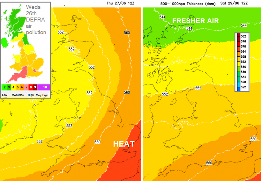
An Atlantic low pressure will be the dominant feature for the end of the week. Yesterday the heat was still being drawn up from the southwest, ahead of the low. Into the weekend fresher air will be directed from the north Atlantic over the UK around this low pressure. It will be blustery in the north and west with fresh even strong south veering westerly winds. These will be gusty for the hills and exposed coasts of Northern Ireland, the Isle of Man and northern Britain today and overnight. The fresh and gusty westerly winds will last during Friday over Scotland with strong winds and even gales for the far north. The air quality should improve, after moderate levels of pollution, even high levels of Ozone in London on Wednesday.
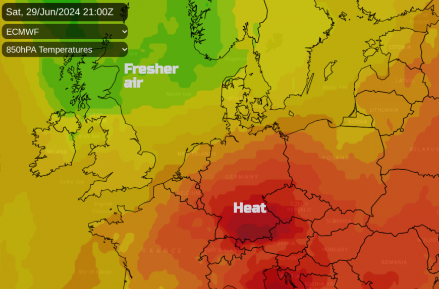
Another pulse of heat will move out of north Africa, over the western Mediterranean, across the Alps on Saturday and into southern Germany where temperatures will move into the low 30sC. There are already heat warnings in Germany and the Saturday evening Euro match will be very warm, around 28C in Dortmund in the west with rain possible by Sunday when it will be cooler in Cologne. This cooling is the same air which will be over the UK, reaching its way into northern mainland Europe. The heat will extend eastwards into the Baltic States, down through the Balkans and Greece.

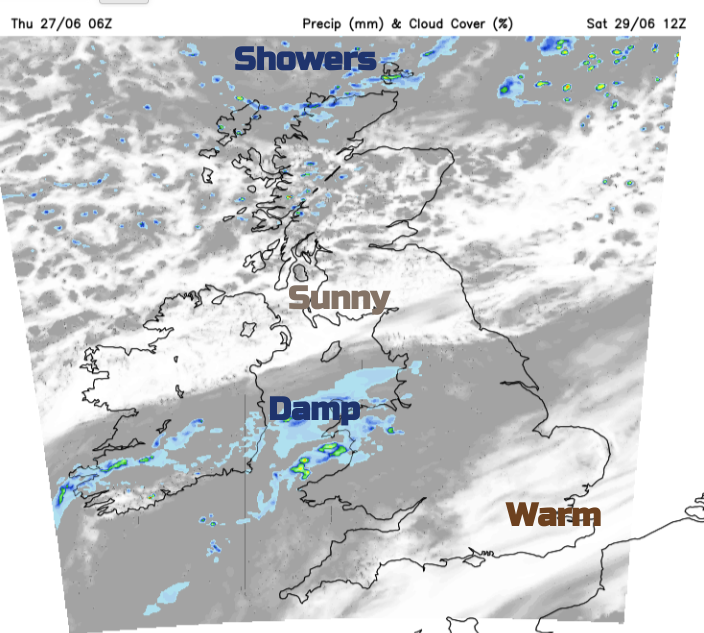
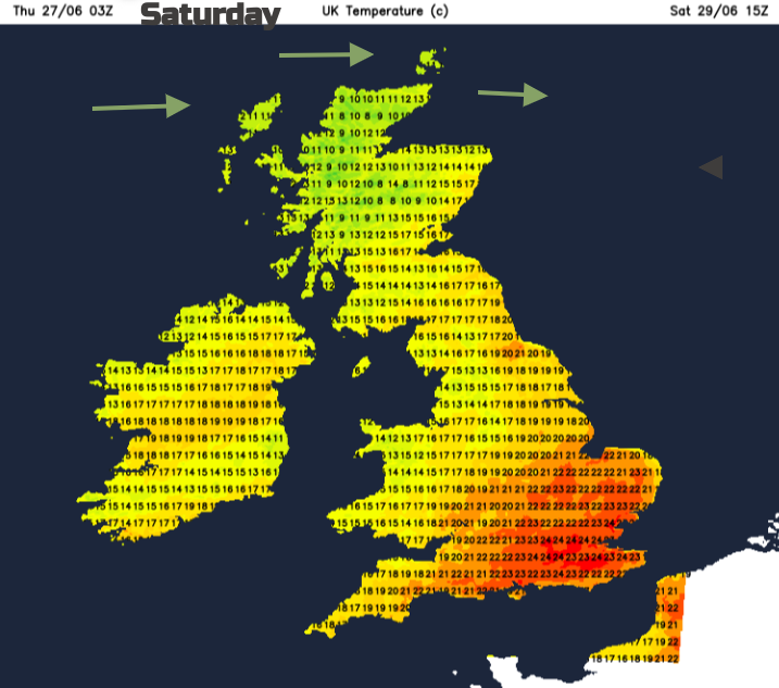
Southeastern England will have a pleasant end to the working week. Temperatures will be around 19 to 23C. It will be fine and bright with sunny spells and very light winds. It won’t be the sultry heat of earlier in the week but still warm enough. Much of the rest of the UK should be dry and bright, not as warm but any evening sunshine will be welcome with a westerly wind. There will be a few showers over northern Britain with frontal rain and cloud for the Northern Isle.
Cool in the north overnight with incoming cloud and patchy rain to southern Ireland
A small frontal feature will edge into Wales from Dublin early on Saturday. This will bring more cloud and patchy outbreaks of rain. It will mainly affect Angelsey and Gwynedd in the morning, then the northwestern half of Wales after lunch. The frontal cloud and potentially some afternoon dampness could affect Merseyside and Lancashire with the cloud extending over the Pennines. To the north, it will be sunny with ongoing blustery showers for the Highlands and Islands. It will be fine and sunny and warm to the south and southeast of the frontal cloud, around 20 to 25C.
The air flow veers to the northwest and the northern half of the UK will have a cooler night. The last of the frontal patchy rain will move southwards through Wales to the Bristol Channel but shouldn’t bring much bother to Glastonbury on Sunday morning.
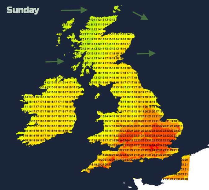
There could be the odd showery outbreak for southern counties of England as the fading front clears off over the English Channel. Overall Sunday looks fine and bright with warm sunny spells and light winds. The southern half of England will again see temperatures in the high teens to mid 20sC.
Elsewhere more places could see the high teens and feel warmer in the strong sunshine. Scotland will still have a moderate westerly wind, but it will ease through the day. Sunday evening looks fine for most of the UK.
Loading recent activity...