Cooler air is on the way for midweek with a touch of frost in places by night and even snow for the tops of the Scottish mountains. We have reached into the low twenties recently with weekend top temperatures of 22.3C in Edinburgh on Saturday and 24.1C at London Heathrow on Sunday. As this colder plunge of air from the north arrives, daytime temperatures will be in the mid-teens although with warm sunshine. You will notice the cool difference in the shade, in the evenings and tender garden plants might need some attention.
If you are cutting a long lawn, there will be showers to dodge, more so in the north and west.
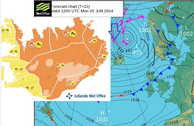
It’s all starting near Iceland today. A deepening area of low pressure is drawing down cold Arctic air and the Icelandic Met Office has issued yellow and orange warnings for northerly gales and snowstorms.
“Outdoor activities likely to be dangerous due to cold weather and hardship. Travelling can be hazardous, especially for vehicles sensitive to wind. Snow can be expected on mountain roads, with difficult driving conditions or possibly impassable roads.” Vedur
For the UK, nothing so dramatic but there will be a shift, especially in the north. Frontal bands will push southwards over the UK on Tuesday bringing down the colder air. The low centres lurk over the southern Norwegian Sea or close to northern Scotland through this week. An area of high pressure over the northern Atlantic will edge back towards Cornwall on Wednesday. This combination means there will be a lot of drier weather for southern Britain and often sheltered eastern counties but there will be plenty of showers brought in on the northwesterly flow. These will reach Northern Ireland, particularly the north coast, and north and western Scotland. Over the high ground of Scotland, there could be wintry flurries too. Northwest England, Anglesey and the Pennines will see a wet day on Tuesday as the frontal bands pass by with a scattering of showers to follow.
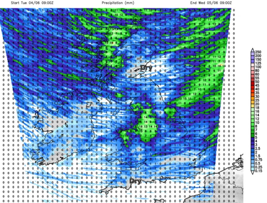 Heaviest rain this week always from the northwest
If you are in the drier, brighter weather it won’t feel too bad in the sunshine which is strong at this time of year. However, if you are in the blustery wind, near a passing shower or under the frontal rain bands, it will feel colder. You’ll notice the difference in the air. It’s not ideal for June when the UK weather seemed to have found its summer vibe.
THIS WEEK Monday
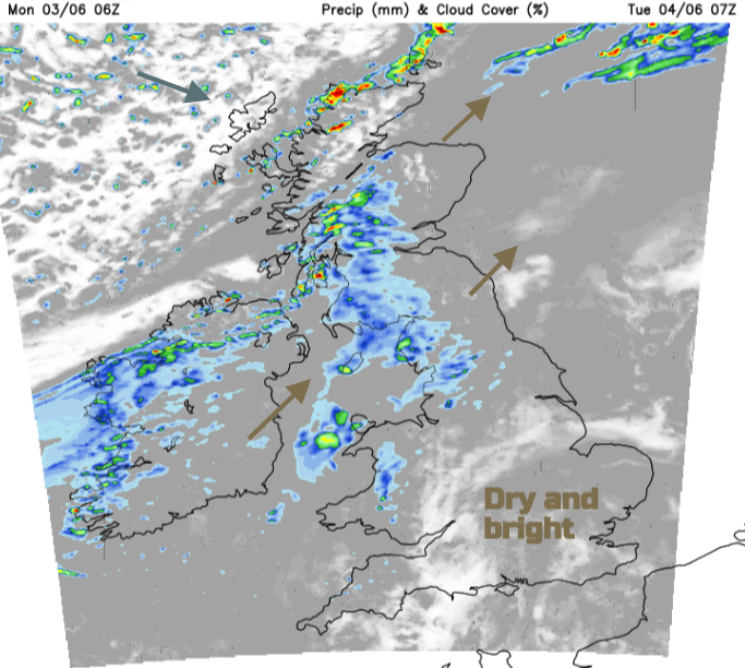
The working week has started with a lot of cloud cover over the UK although parts of Scotland are enjoying clear blue skies and sunshine. Southern and eastern Britain will feel warm with temperatures in the high teens to low 20sC and there will be a quiet end to Monday everywhere.
As Iceland braces itself for a wild and wintry spell a weak weather front over the UK will pep up and bring damp weather from the Atlantic.
Tuesday
There will be very light winds over London and the Home Counties to start Tuesday. Further north a moderate southwest wind will veer to a cool, brisk northwesterly. Frontal rain will move from Northern Ireland across the Irish Sea to SW Scotland, NW England clipping northern and western Wales. To the north of this, there will be lines of lively, heavy showers but with plenty of sunshine.
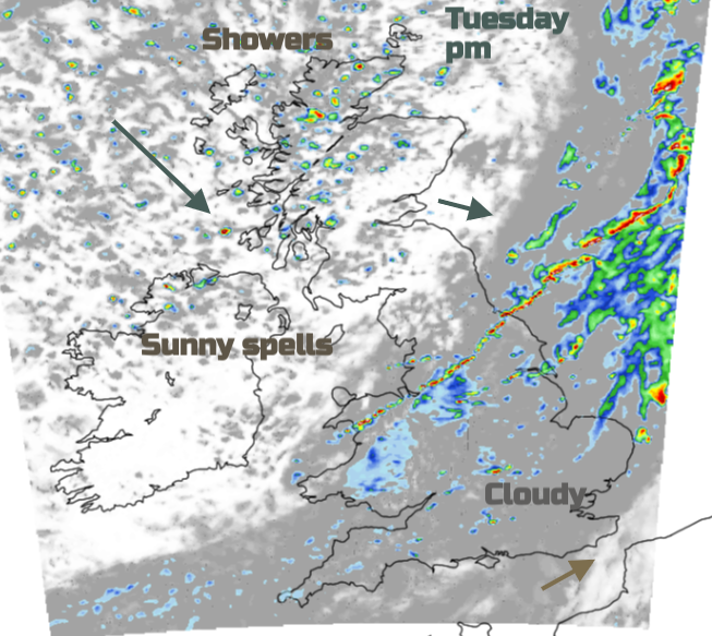
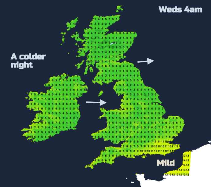
There will be clear skies for much of the UK and a cooler night. The temperatures fall away where the winds are light. Showers will continue to arrive from the northwest over Scotland and Northern Ireland with a few reaching Cumbria. Some of these will be heavy with hail.
Wednesday
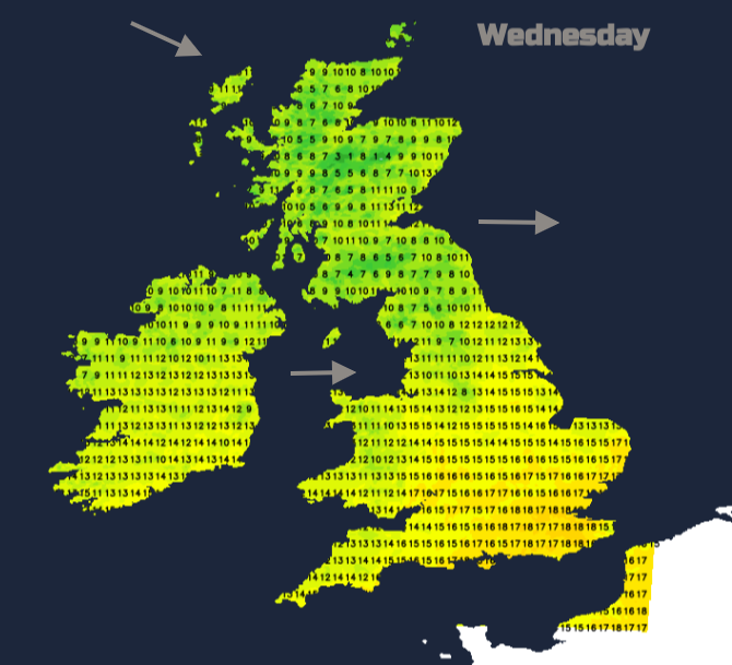
The last of the mild air will be pushed away from southeastern England on Wednesday morning. There will be plenty of fine, dry weather with sunshine but this cooler edge to the air. Cornwall across to west Sussex will hold onto the sunshine, closer to the high pressure. Elsewhere, cumulus cloud will fill in with more showers appearing. These will mostly be over northern Britain and Northern Ireland but still well scattered in a westerly wind. There will be some heavy downpours and the odd rumble of thunder is possible with snow over the mountain tops.
End of the week
The showery picture continues into Thursday with a rash of showers developing and more heavy ones for northwest Scotland in the morning heading into central Scotland by lunchtime on blustery winds. Further south there will be a lot of bright, even sunny, weather with temperatures 13 to 17C. Friday sees plenty of showers in the north with stronger winds
This cooler theme lasts into the weekend, with more nippy nights but there will be a lot of fine weather away from the showery flow in the northwest.
Loading recent activity...