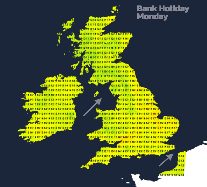
The Bank Holiday Monday UK weather includes bright or sunny spells but also a rash of showers developing, with thunderstorms for northeastern Britain
The Bank Holiday weather includes bright or sunny spells but also a rash of showers developing, even thunderstorms for northeastern Britain
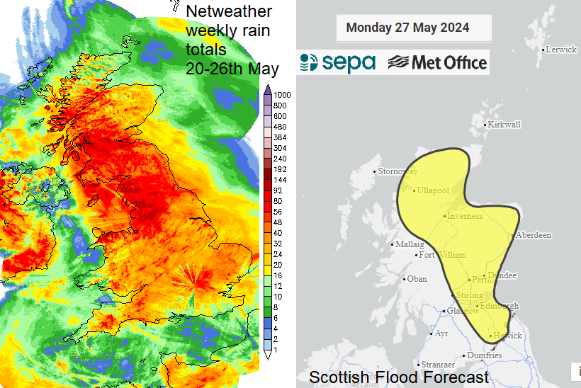
It’s been a mixed weekend so far. The top temperature on Saturday 25th was 21.6C in London. Suffolk saw 20.9C on Sunday, no high heat for late May but even so, with light winds and sunshine, it has been pleasant at times. Sunday brought lots of showers with parts of the UK seeing more soggy weather after the midweek downpours. For Monday, the winds are mostly light and the west to southwesterly flow will guide showers across the UK.
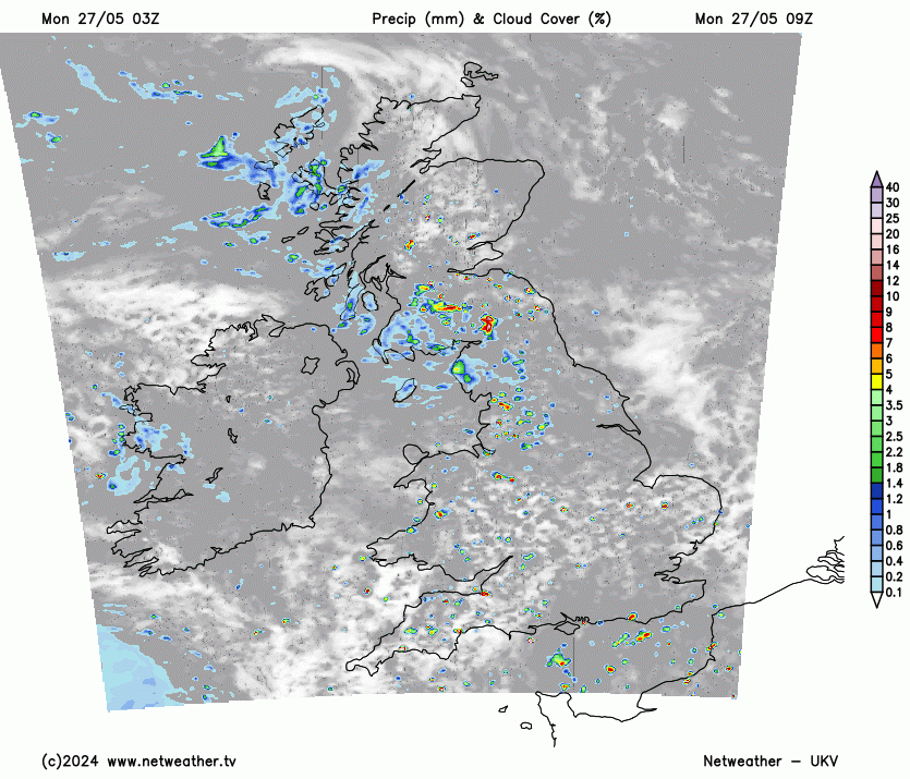
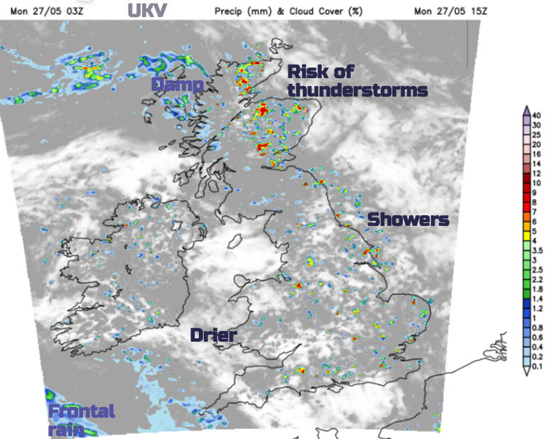
The wettest area to start Monday has been over NW England and around the Solway Firth but this will drift northeastwards over Scotland. Elsewhere in England, a rash of showers develops with some heavy slow-moving downpours. You may miss the showers and see sunny spells. Or you get caught in a downpour. These fade from the southwest later in the afternoon and the Isle of Wight should have a fine sunny afternoon. Much of England will be 13 to 17C but London could reach 19 or 20C for Bank Holiday Monday. North Sea coasts of Yorkshire and around the Humber will see lively downpours develop in the afternoon. There is a low risk of a thunderstorm in northeastern England with hail, heavy rain and sudden gusty winds.
Showers will soon develop in situ for Scotland but the early instability over southwestern Scotland edges northeastwards. This focus for showers heads across Edinburgh and up to Grampian where there is a Met Office thunderstorm warning from mid-morning onwards. Hillwalkers from the Pentlands up to the Cairngorms, do be aware of this and keep an eye on the radar (with sferics/Lightning strikes on) for the wider convective picture.
For Scotland, the heaviest showers will be in the central and eastern thirds of the mainland. The western third keeps more low cloud and patchy light rain this morning but should brighten in the southwest this afternoon, say for Arran, Jura and Islay.
With hardly any breeze for the northeastern half of Scotland
“Slow-moving heavy showers and thunderstorms may cause flooding and disruption in places." MO
Some parts of the UK have seen a very wet few days so another heavy downpour could easily cause localised flooding issues. Something to bear in mind if you are travelling home today, or on half-term holidays where you may not be familiar with which routes tend to flood readily.
Northern Ireland will see a good deal of fair weather with a scattering of showers. The early low cloud and showery rain along the east coast will clear away and the cloud will lift for Giant’s Causeway visitors and Rathlin Island. Mostly it will be bright with more sunny spells late afternoon and temperatures around 14 to 17C.
There will be a scattering of showers for Wales, with some heavier ones inland. The south coast will brighten up with sunshine as Cardiff reaches 17C. Anglesey should soon dry up with a fine, bright day although in a slight SW breeze. There will be an onshore breeze for Cardigan Bay but the day becomes more settled and brighter with fewer showers late afternoon. Pressure will be rising ahead of the next weather system, away to the southwest.
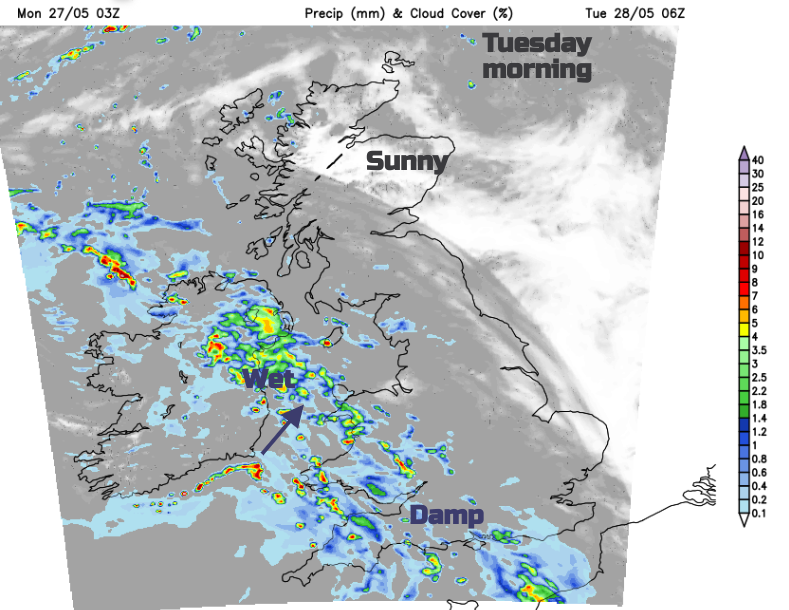
Tonight and Tuesday morning
The showers in the far northeast will fade this evening as skies clear over much of Britain. It will feel nippy this evening with temperatures overnight falling down into single figures. Northern Ireland will keep more cloud cover and an Altnaitc frontal system will reach Cornwall and Devon on Monday evening. This will throw rain and cloud into Wales before dark and this band of cloud and rain will be over Northern Ireland, the Irish Sea, Wales and the West Country for those heading back to work on Tuesday morning. The damp weather will soon reach Manchester, Birmingham, London and the Home Counties.
Loading recent activity...