Every spring, the stratospheric polar vortex transitions from its westerly wintertime state to its easterly summertime state due to seasonal changes in incoming solar radiation, an event known as the “final stratospheric warming” (FSW).
The final reversal of stratospheric winds, may be smooth and late, mainly controlled by the solar radiative heating of the polar region, or early and abrupt with rapid increase of polar temperature and deceleration of the zonal wind, forced by the planetary wave activity.
Could there be a final stratospheric warming in early March, with no recovery of the polar vortex until autumn?
This differs from a Sudden Stratospheric (SSW), which occur during winter or early Spring and are a temporary reversal of zonal winds in the stratosphere at 10 hPa 60N, with the polar vortex eventually recovering and stratosphere winds turning westerly again.
Generally, FSW occurs early when the planetary wave activity is relatively strong in the Northern Hemisphere, mainly during the middle and late March; however, when solar heating acts as the main factor, FSW may not occur until early May but sometimes they can occur as early as March. The average date for their occurrence is around the 16th April.
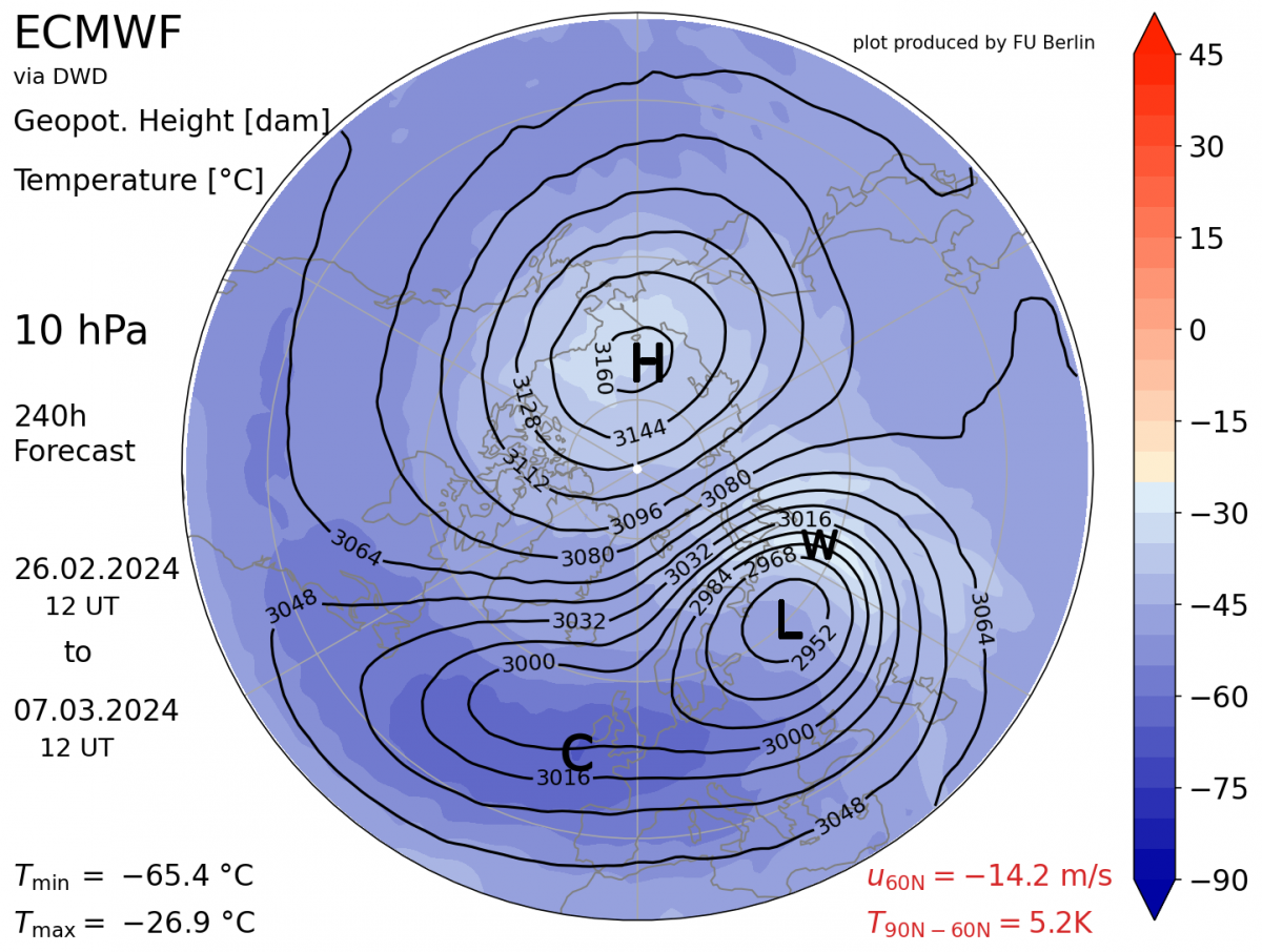
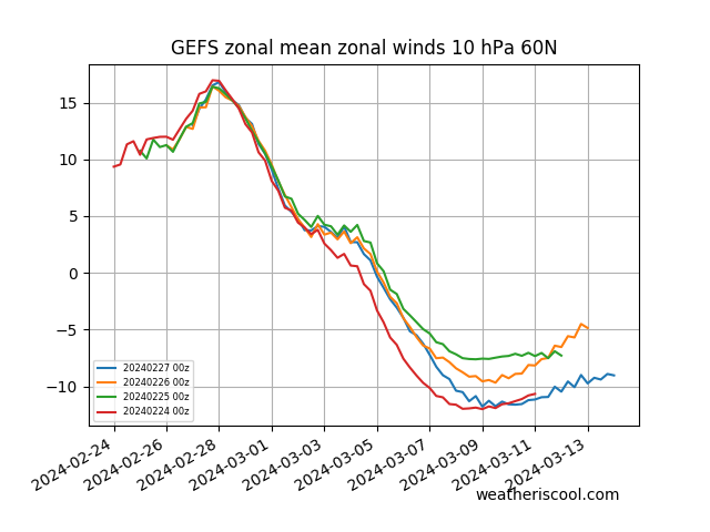
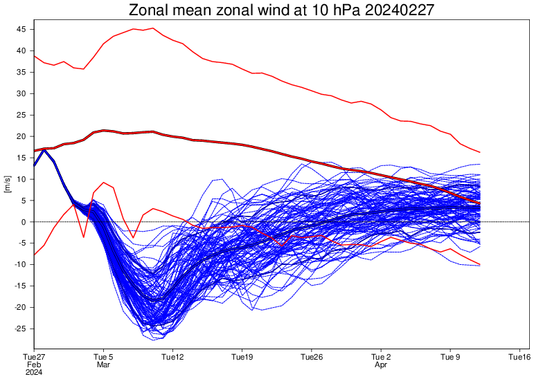
However, for a while now, GEFS in particular, has been indicating a reversal in zonal winds at 10 hPa 60N in early March, around the 5th, with no recovery, recently the ECMWF extended runs (EC46) has been trending this way, though still recovers to a very weak vortex. Both models indicate a displaced stratospheric polar vortex, rather than a split. The polar vortex displaced towards Europe.
So could this SSW or even a FSW have implications for our weather? Normally the FSW takes place in April, so by the time the reversal works down to the troposphere and increases the chances of high latitude blocking, much of the higher latitudes of the northern hemisphere are already warming up with the longer days and higher sun angle. However, in March there is still deep cold air at higher latitudes to tap into, so following an early March SSW, any high latitude blocking that may develop could push cold enough air south or southwest across Europe to bring below average temperatures and wintry conditions.
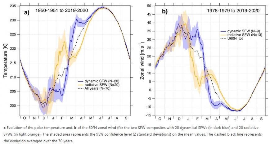 Source: Nature.com
So following a winter without much cold and wintry weather away from northern Scotland, there is an increased risk of a bitter blow before spring warmth takes hold. But often spring warmth comes in fits and starts with cold and wintry set-backs in spring can occur without a SSW. But a SSW just increases the chances of a more prolonged below-average cold spell.
However, its not straight forward to assume a SSW of FSW will lead to cold weather, with lots of variables complicating any reversal in the winds high up in the stratosphere propagating down to the troposphere, where our weather happens, and bringing high-latitude blocking.
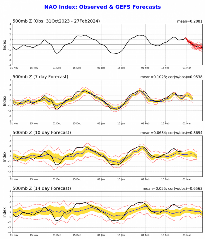
On average, a major Sudden Stratospheric Warming does lead to a Negative North Atlantic Oscillation (-NAO) which is often associated with blocking high pressure near or over Greenland – which forces the Atlantic storm track further south and also causes cold air to push south into Europe, including the UK. The NAO is closely related to the Arctic Oscillation, so when the NAO goes negative the AO goes negative too, pushing cold arctic air south to lower-latitudes.
We’ve already seen two very brief SSWs since the New Year, one in January and another one recently around 18/19th February, but the stratospheric polar vortex quickly recovered following each brief reversal. However, the one forecast in early March looks more sustained and there could be no recovery until late autumn. Having 2 SSWs in one winter is not very common, but having two SSWs followed by another SSW or FSW in early March must be pretty rare.
It usually takes a week or two for the reversal to propagate from the stratosphere, where the disruption comes with a pronounced warming — to the troposphere, where our weather happens. Even it does happen and initiates high latitude blocking, i.e. near Greenland, there is no guarantee that cold air will reach the UK, as areas of low pressure and high pressure need to align in a particular way for this to occur.
Cold air that has built up at high latitudes in polar regions will be fighting an increasingly losing battle to spread south against the seasonal cycle of warming through spring, in addition to background global warming, with all of the last 10 months each being the warmest on record. If all does align and cold air spreads south from the arctic into Europe, including the UK, then its likely to be in the 2nd half of March and perhaps into early April, perhaps including Easter.
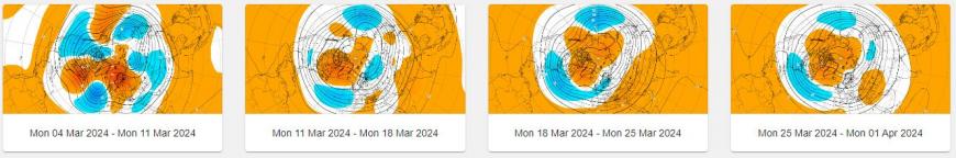
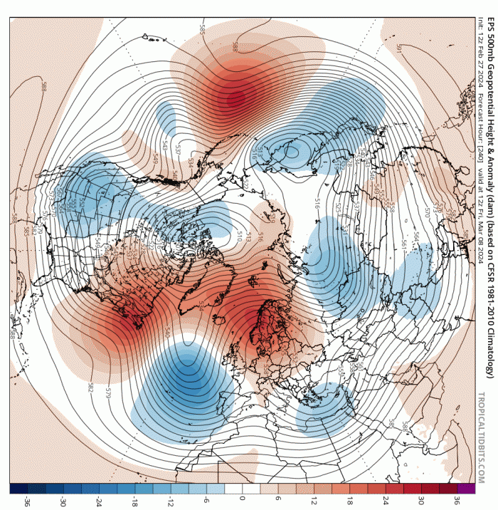
Longer range modelling, EC46 for example, does forecasting high latitude positive height anomalies to the north from Scandinavia to Greenland, indicating potential for blocking high pressure in this area between mid-March and the beginning of April.
EC46 through March shows signal for northern blocking (orange-positive height anomalies . blue-negative anomalies = -NAO)
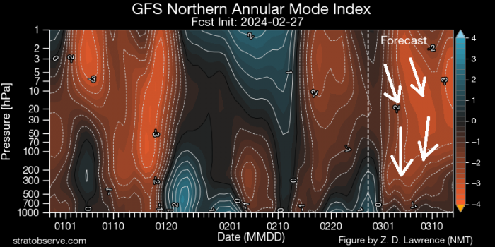
North Atlantic Oscillation turning negative ...
However, the EC46 daily runs had a persistent signal for high latitude blocking through much of February too, but this never verified in reality, so confidence in this long-range guidance is low. However, there is currently a reoccurring signal even at the end of the medium range for a blocking high to develop to the northeast over Scandinavia. So we may see blocking develop to the northeast initially, before extending or migrating towards Greenland
Latest EPS 500mb height mean and anomaly at day 10 shows blocking developing over Scandinavia
The prolonged nature of the SSW reversal being forecast increases the chances of a colder second half to March I think, but by no means will it likely happen.
Loading recent activity...