Becoming unseasonably mild across England and Wales next few days, but there will be some rain around too. Mild and often unsettled through into next week, but there is a signal for chillier conditions later next week, but remaining unsettled.
It will turn increasingly mild through today and tomorrow behind a warm front lifting north across the British Isles today. Colder air will still hanging on across Scotland today, but retreating to the north of Scotland tomorrow. Temperatures will be well-above average across England and Wales over the next few days, with winds backing southerly tomorrow, drawing air up from the western Mediterranean. This will allow temperatures to reach the mid-teens across eastern England, perhaps as high as 16-17C tomorrow. A cold front will clear east across the UK on Friday, introducing slightly cooler air from the west off the Atlantic. But temperatures still remaining above average across England and Wales into the weekend.
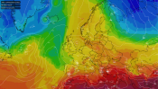
Very mild air being pulled up from the south next few days ...

Not only will it be mild, it will often be cloudy and breezy with further spells rain for many for the rest of the week and through the weekend, thanks to the mild and moist south to southwesterly flow and occasional fronts moving through across most areas from the southwest or west. The rain could be locally heavy and persistent, which falling on already saturated ground and into already high river levels, could cause some localised flooding.
Unsettled weather looks to resume next week, after a brief ridge brings a drier blip on Monday, with pressure falling from the west and spells of wind and rain moving east off the Atlantic across all parts. But after a mild start to the week, it looks to turn colder, as bouts of polar maritime air spread in from the west, with rain turning increasingly to snow across northern and western hills towards the end of the week. These chillier but unsettled and sometimes windy conditions could prevail to the end of the month too, though uncertainty for now.

Back to today and quite a contrast this morning between north and south, it was still 0.8C at Aviemore in the Highlands at midday, while it was close to 16C in Hereford in the west of England. The warm front separating mild air over England and Wales and cold air over Scotland is lying across southern Scotland with a band of rain and will lift north through the day across Scotland – reaching northern Scotland this afternoon, turning to snow over higher ground as it moves into cold air. England and Wales very mild today but generally cloudy with outbreaks of rain or showers spreading northeast, with some drier interludes.

Temperatures reaching 10-13C generally across England, Wales and N. Ireland, perhaps 14-16C across central, southern and eastern England. Well above average for the time of year. Scotland a cooler 6-8C.
Then a cloudy night, with showery outbreaks of rain continuing to work their way northeast across the UK tonight, some heavy bursts across northern and western areas. Turning drier across southern England towards the end of the night. Unlike last night, frost-free across Scotland, a very mild 10-12C the low across England, Wales and N. Ireland.
A very mild start to Thursday across England and Wales. A rather wet start to the day across Scotland and northern England, with some heavy and persistent rain, this should clear northeast through the morning, but a cold front moving slowly in from the west will see further pulses of heavy rain move northeast along it across SW England, Wales, Midlands and northern England through the afternoon and evening, before the band of rain clears east across England Thursday night. Ahead of this rain, turning drier towards eastern England and should there be some sunny spells here, temperatures could reach 16C - 17C in the southerly flow drawing air all the way from the western Mediterranean.

The Met Office have issued a yellow rain warnings across SW England and the English Midlands for the heavy rain pushing northeast later on Thursday:


Rain or showers should clear eastern areas first thing on Friday, leading to a mostly dry day with sunny spells as a transitory ridge of high pressure builds in. Not as mild, thanks to the cold front clearing the east early on, but still above average in the south.
The east should stay dry and bright on Saturday, but after a dry morning cloud and rain spreading in from the west through the afternoon across the west. Another mild day. A band of rain clearing east across the UK Saturday night, could drag its heels across southern areas Sunday morning before clearing, otherwise, becoming drier and brighter, with just a few showers in the west.