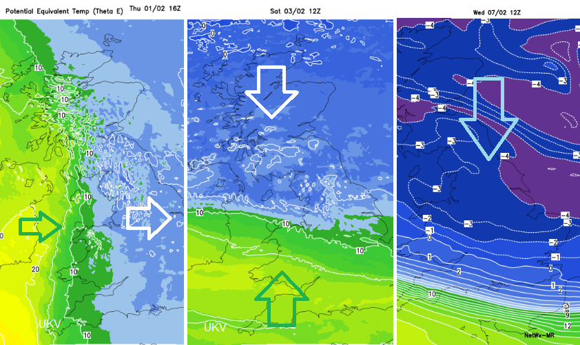
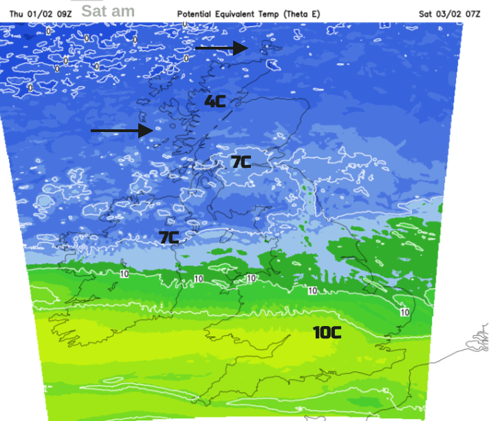
For early February the boundary line of cold air to the north and milder conditions to the south continues to waver across the UK, well into next week. At times the cold air reaches down turning showers wintry for Scotland, and we see frosts by night. At other times, it is unseasonably mild as we saw at the weekend. The air mass boundary has been obvious on recent weather charts, with different temperatures, wind directions and the frontal rain and cloud.
There have also been developments along this boundary, as happened in the middle of the week when Storm Ingunn passed by to the north of Scotland. There was plenty of sea around before Ingunn reached its country of naming, Norway, but even so, the Faroe Islands looked to have received a sting jet hit with gusts recorded near to and over 100mph. The sustained winds reached Hurricane Force at around 80mph. Central parts of Norway were under a red wind warning as the storm arrived later on Wednesday 31st.
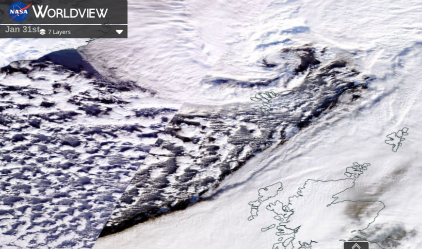
NASA Satellite image of Storm Ingunn over the Faroe Islands, northern Scotland on its way to Norway
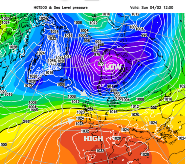
The boundary front could be viewed like a skipping rope lying on the ground. If someone flicks it up from one end, that is like the developing fronts which flow across the Atlantic, engaging with the active jetstream and deepening on their way eastwards. A double structure of two low centres will be near Iceland on Thursday night with one warm front reaching Scotland. High pressure lurks near southern Britain, allowing a lot of fair weather but these ripples will bring pulses of rain and cloud with northern parts remaining blustery, and windy on Saturday for the Northern Isles.
Overall the flow remains from the west, coming in off the Atlantic. So western shores will be damp at times, depending on the position of the shifting fronts. Bear that in mind if you are looking at rain timings on a Weather App, especially by Sunday. The frontal rain and drizzle may just be a bit slower or further north.
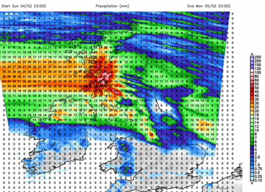 Western central Scotland looks very wet for Sunday into Monday with rain for Northern Ireland and Cumbria. Many other parts of the UK could see a dry end to the week. Wales will see some rain although perhaps sheltered in Powys. Eastern parts of northern Britain may not be immune to the frontal rain from the Atlantic.
Much of the UK will see a dry end to the working week although there will be patches of thicker cloud and patchy rain for western England and Wales with a few showers for western Scotland. Friday ends with the mild air across much of the UK but with colder air approaching from the far northwest.
Temperatures in southern Britain will be in double figures, still in the mild air around 10 to 14C. Further north and for Northern Ireland it will be 7 to 9C and feeling colder in the brisk westerly wind. The frontal boundary will bring thicker cloud and patchy rain to SW Britain but will edge northwards up through Wales during the day. Other areas will be fine and bright although the feed of showers (some wintry) for Scotland continues for northern and western parts. Cool in the north overnight but still mild in the south
The showery flow clipping the far north of Scotland will reach down into Grampian by Sunday morning. The gusty winds will reach down the east coast to the Pennines. Sunday will see more cloud across the UK and a warm front edging northwards ready to bring a wet end to the weekend for western Scotland. However, again many parts, especially eastern Britain, will see a fair day.
Next week there are signs of the colder air plunging southwards with snow showers from the north on Tuesday. Remember, they don’t tend to reach too far down through the UK. There are also signs of an Atlantic low arriving from the southwest and hitting that cold air by Thursday. That is a long way off, but it would bring rain, sleet and snow although a good deal could change. There looks to be a shift to colder air reaching down through more of the UK next week.
Loading recent activity...