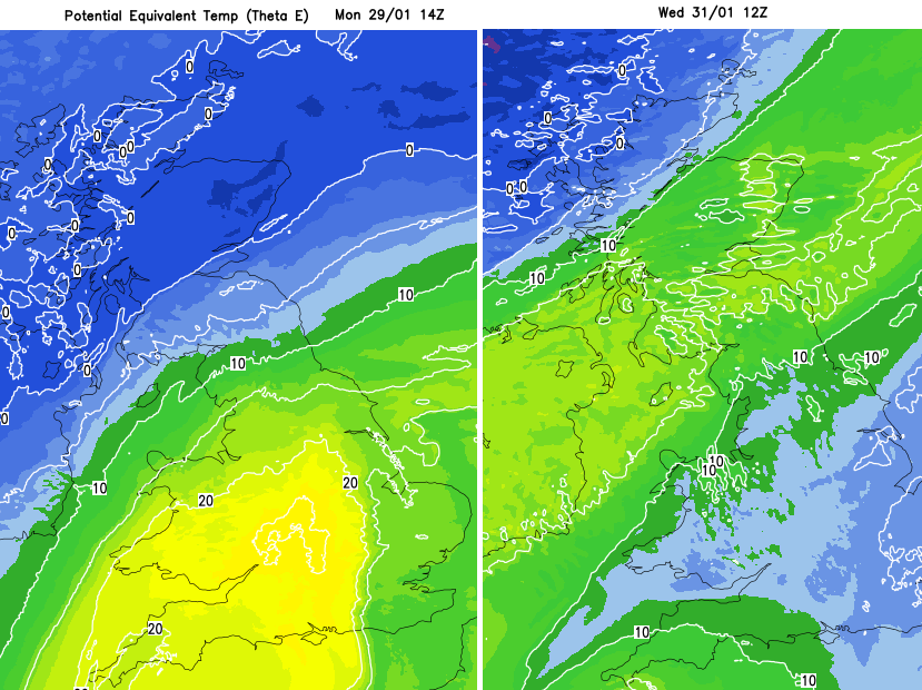
Some chopping and changing this week with our UK temperatures as we sit near the airmass boundary with colder air in the northwest and milder air hanging on in the south. Northern parts of the UK will often be windy, with concerns about a deepening low early on Wednesday, impacting northern Scotland.
With southerly winds from Spain, it was a mild but windy Sunday.
[Update 15:30 Monday] Achfary, an official station which doesn't automatically send its data, it is checked daily manually, recorded 19.9C.
In the NW Highlands, Kinlochewe saw (provisionally) a new January daily maximum record for the UK, reaching 19.6C due to the Foehn Effect. This is where mild, moist air dries and warms over high ground in brisk winds. It is often responsible for our highest temperatures in winter, found to the lee of high ground. The previous record for January was 18.3C and had been recorded four times in past decades.
Edinburgh saw 11.7C on Sunday, Rhyl 14.3C, Brize Norton 13.1C, and in Northern Ireland, Magilligan saw 14.7C, so all were milder than average for this time of year. Yet not the Foehn Effect boosted high of nearly 20 Celsius. Some parts of Britain did feel cooler in the brisk wind with more cloud and a damp feeling in the air. Air temperature is recorded in a sheltered, shaded box, the official Stevenson Screen. What it feels like will vary for different people.
We start Monday with a waving frontal boundary bringing rain across a central swathe of Britain, the Irish Sea across to Dublin. To the northwest of this is colder air (but not especially cold) with high pressure building in from the west. To the southeast of the front, the mild air from the weekend holds on, and this contrast will stay until later on Tuesday. The associated low centre will head off to Denmark, and the cold front will push into northern Germany and the Benelux countries.
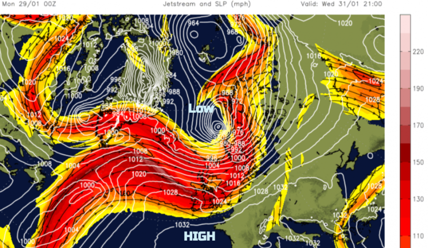
High pressure will nip past England and Wales on Tuesday night, but a vicious low, a rapidly deepening storm, will pass between Iceland and Shetland on Wednesday on its way to Norway. As its fronts pass over the UK, there will be very windy weather in the north and lively downpours. Disruption to travel in northern Scotland, particularly for the island ferry services, looks likely, and there is a yellow wind warning already. “Gusts of 65-75 mph are likely, with a few places perhaps seeing gusts of up to 85 mph at times.” MO
The UK sits along the main air mass boundary this week, with further mild surges lifting temperatures into double figures. Colder air will then swipe in from the west or northwest, and the risk of frost returns. It’s not the icy Arctic grip from the north that we experienced earlier in the month, but it will feel cold for those with fresh winds. Friday morning charts show mild air but blustery winds again, with the strongest winds in the far north.
Monday
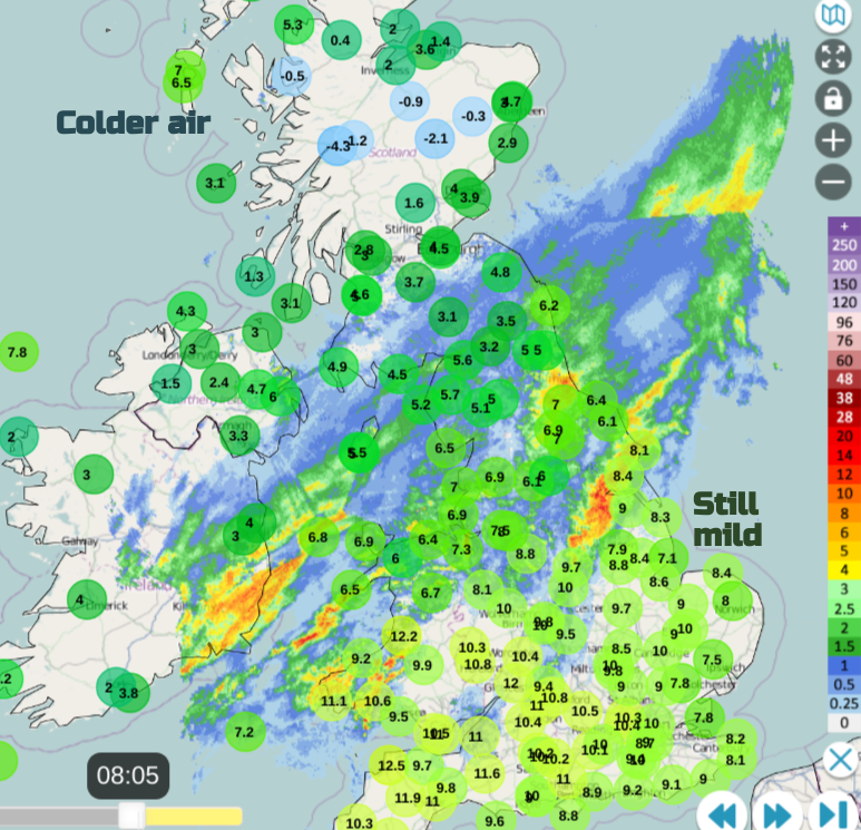
The wettest areas will be the Pennines, North Yorkshire Moors, Snowdonia and Pembrokeshire from Monday’s frontal band. Much of Scotland and Northern Ireland stay dry, away from the southeast, with more sunshine appearing from the west. Southeastern Britain also stays dry with occasional bright spells. Both of these drier regions will have southwesterly winds. The waving frontal band develops a low centre, and the winds begin to swirl around. In a brisk northeasterly wind over northern England and catching the Southern Uplands, there could be sleet and wet snow over the hill tops and with an unpleasant Monday for higher level routes.
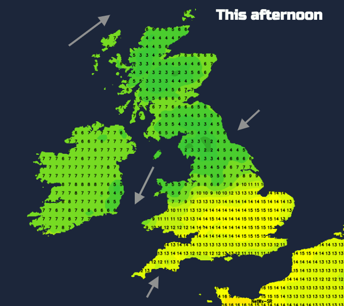
Southern Britain could still see 10 to 13C, so milder than usual, but further north and under the rain, it will only be 6C and feel colder if you are in the wet and windy section. Pulses of heavy rain move from southern Wales across the West Midlands towards the Humber this evening. The frontal rain will ease later in the day and clear away over the North Sea. However, the northeasterly feed around the top of the low will continue to feed in damp weather and low cloud.
There is a Met Office yellow Rain warning in place until Tuesday morning
“Rain becoming prolonged and heavy at times during Monday afternoon and evening, easing from the west overnight. 20-30 mm of rain falling widely with 40-50 mm in a few places.” Met Office

The skies will be clear over Northern Ireland and more of Scotland (away from the southeast), and temperatures will fall just below freezing with the risk of frost and even freezing fog.
It won’t be as mild in the south on Tuesday, but still, temperatures will be around where they should be for the end of January at 7 or 8C. Many parts of the UK will have a fine, sunny day offsetting the colder air. Much of England will start the day with more cloud, but this should break up and drift away eastwards, although lasting longest for London and the Home Counties. The southwesterly wind will veer to a northwesterly over England on Tuesday morning and this will help the colder air move in. By Tuesday evening, the southwesterly winds will strengthen over Scotland, ready for a wild start on Wednesday morning.
Loading recent activity...