
After a wintry start this week in the south, it will be Scotland seeing snow showers by the end of the weekend. Next week looks cold too with frost for many.
This week has felt colder, especially in the wind from the east. A few places even saw snow, including the Channel Islands. High pressure has settled over the UK now with a lot of dry weather although the cloud off the North Sea is sometimes thick enough to bring patchy rain. This can turn icy, even to wet snow over the hills of northern Britain. The air isn’t as cold now, shifting from that raw feeling on Monday in the south to a damp coldness which doesn’t feel too bad when it is sunny and calm. The chill will return, from the north, for next week. This northerly flow will bring snow showers, starting on Sunday.
The next few days see a gentle flow from the northeast bringing more cloud to England and inland Wales. At times there will be patchy rain, mainly for northeastern England and the Pennines with a bit of icy rain or wet snow over the hills. Also a few showery bits into the Moray Firth today. The winds fall light by Friday for many areas and there will be fog and frost, with a risk of ice in places. It looks nippy for southern England on Thursday morning and a hard frost inland for a time overnight in Scotland for Thursday night. By Friday morning temperatures will be at or below freezing for a good part of the northern half of the UK away from the breezier far north of Scotland. Saturday morning looks chilly for Wales with hardly any wind. By Monday morning, there should be a widespread frost ready for the commute to work and school.
 Theta E/ Potential Equivalent Temp charts showing change in air mass over the UK this week
There will be a shift to colder air through the weekend but it’s from the north, across the sea. The rare easterly setup, fondly known as a ‘Beast from the East’ needs a high pressure over Scandinavia to anchor a steady flow of deep cold from Siberia or eastern Europe. There is still time for that, many are watching developments and forecasts way up, at Stratospheric level. The 2018 event didn’t occur until the very end of February.
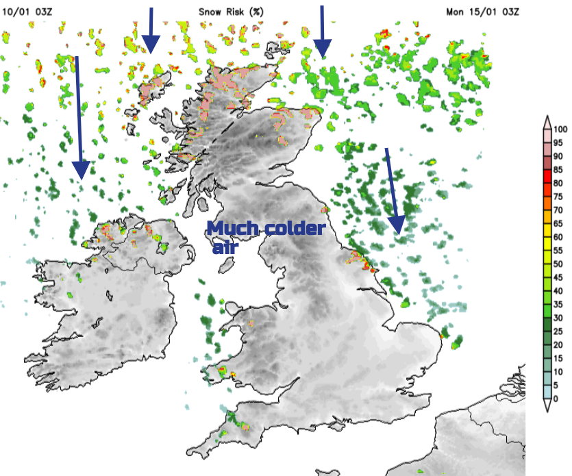
In a northerly flow, northern Scotland can get clobbered by heavy snow showers and small trough lines. Sometimes small circulations known as Polar Lows are pulled down the Norwegian Sea and these can bring disruptive snow as they reach land. For most of the UK, you have to imagine a wishbone shape. A host of snow showers at the top and then a split into two parts. Some showers flow down the North Sea and east coast of Britain and the other half reaches Northern Ireland, north Wales, even north Devon and Cornwall. If the flow backs or veers a bit, different areas become the focus for the wintry showers. Perhaps moreso western Scotland and the Scottish Islands, or veering and clipping the North Yorkshire Moors and Norfolk.

The Saturday surface pressure chart shows low pressure over Scandinavia steering the cold Arctic air down past Norway. The occluded front will bring patchy rain over Highland Scotland on Friday night with a little snow for the tops. The band of thicker cloud and patchy rain looks to reach Northern Ireland and the Solway Firth by lunchtime on Saturday so a grey picture here. The blue cold front to the north with dots shows “Cold front frontogenesis – the development or marked intensification of a front”. The UKV model shows a line of heavier wintry showers reaching Scotland on Saturday night and moving southwards as well scattered rain showers on Sunday. Behind this, there will be sleet and snow showers in the wishbone formation.
Also on the pressure chart, you may notice a low pressure away to the southwest. The ECM model shows a frontal band of rain approaching SW Britain but it fades over the Fitzroy sea area. What is catching the eye for snow lovers is a possible scenario next week.
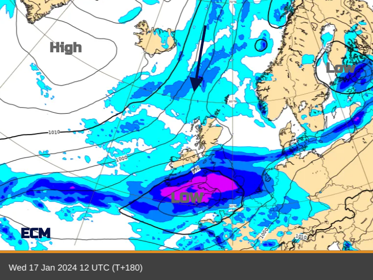
The cold Arctic air should be established across the UK and there is a signal for another Atlantic low to make good progress towards the UK. If this manages to move over Wales and England and hit the cold air, there could be widespread proper snow. However it’s a fair way off, the low may fade or just skirt over northern France. It looks like the cold, showery Arctic flow could just hold on. For now, prepare for a shift to colder air with frost, a bit of fog and the risk of ice and for northern Scotland, snow starting on Sunday. Keep an eye out for weather warnings.


.jpg?w=350)

