


Storm Gerrit recedes, but leaves behind gusty winds, heavy showers, and possible thunder. Northern areas face snow, while flooding and power outages persist, affecting travel.
Storm Gerrit, although now moving away, brought torrential showers overnight, accompanied by thunder and severe gales. Gusts exceeded 85mph across Anglesey and in the west and north. Additionally, snowfall was observed across the Northern Isles and predominantly in the hills of northern Scotland.
Yesterday's heavy rain, falling on already saturated ground, has led to severe flooding. The high winds have also caused power outages, predominantly in Scotland, which will further disrupt travel, with several road and rail links severely affected this morning.
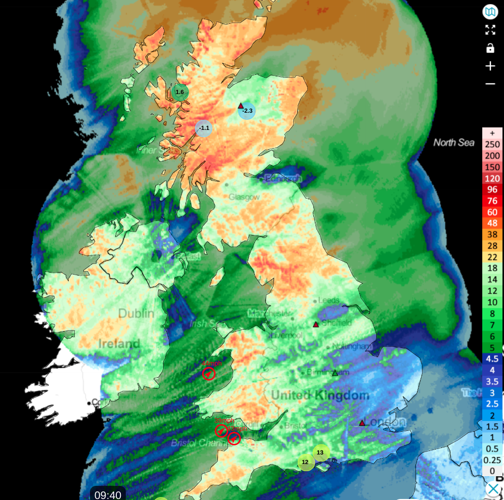 Rainfall totals over the last 24 hours
After a rainy autumn and a particularly soggy December, those in flood-prone areas are understandably anxious about the duration of these conditions. However, relief may be imminent. A stratospheric warming event above the North Pole around the New Year may disrupt the current circulation pattern, potentially ushering in colder, drier weather. This potential change is anticipated after the second week of January, but more wet and windy weather is likely before then.
Yesterday's weather warnings from the Met Office have been cancelled, but a robust southwesterly wind will persist, bringing gusts of 40 to 50mph in the west and north, particularly during heavier, squallier showers. Further sleet or snow is expected over the Northern Isles and in the mountains of northern Scotland, where temperatures will range from 2 to 4°C, feeling cold and raw in the northerly wind.
Elsewhere, expect a mix of sunny intervals and blustery showers, some heavy and squally, with maybe a crack of thunder. An organised band of rain or showers will cross most parts from west to east throughout the day. Despite the wind, it will be mild, even very mild, in central and southern areas, with temperatures reaching 12 to 13°C, but more generally between 9 to 11°C.
After dark, rain will affect East Anglia, the southeast, and the south, but will soon clear. Most areas will continue to experience blustery showers, most frequent in the west and north. Some showers may be heavy, potentially with thunder, especially near south and west-facing coasts, but there will also be clear intervals, especially in more sheltered eastern areas.
Despite the chilly feeling in the brisk southwesterly wind, temperatures will not fall below 6 to 9°C. However, in Scotland and Northern Ireland, colder air from the north will lower temperatures, turning showers wintry, even at lower levels in northern Scotland. Here, temperatures may approach freezing, posing a risk of icy stretches by dawn.
Friday will see the mildest weather in the south, remaining windy with a further scattering of blustery showers and sunny intervals. Expect top temperatures around 10 or 11°C. Further north, a front will introduce colder air into parts of northern England, but the extent of its southern reach remains uncertain. In this colder air, winds will veer north, with showers falling as sleet or snow over northeast Scotland, the Northern Isles, and on southern hills. Temperatures in these areas will not exceed 2 to 5°C.
The situation will remain largely unchanged after dark as the front becomes stationary, leading to a widespread frost in the north with lighter breezes. In the south, it will also be a colder night as winds slightly decrease, but temperatures should remain between 4 to 7°C.


.jpg?w=350)


.jpg?w=175)