Atlantic systems bring windy, wet weather to Northern UK, especially West Scotland, as we end the weekend. England and Wales are drier for now, but unsettled weather will spread south again as we move into the final working week before Christmas.
While Atlantic systems continue to bring windy weather to the North and copious amounts of orographic rain (see below for more on orographic rainfall) to West Scotland, the story is different over England and Wales. Here, an anticyclone (high pressure) to the South keeps it drier, while low pressure towards Iceland sustains a broad south-westerly airflow across the country. Consequently, it's a mild but very moist day, bringing cloud, particularly to the West, before clearer, somewhat less mild air moves in from the North West tomorrow.
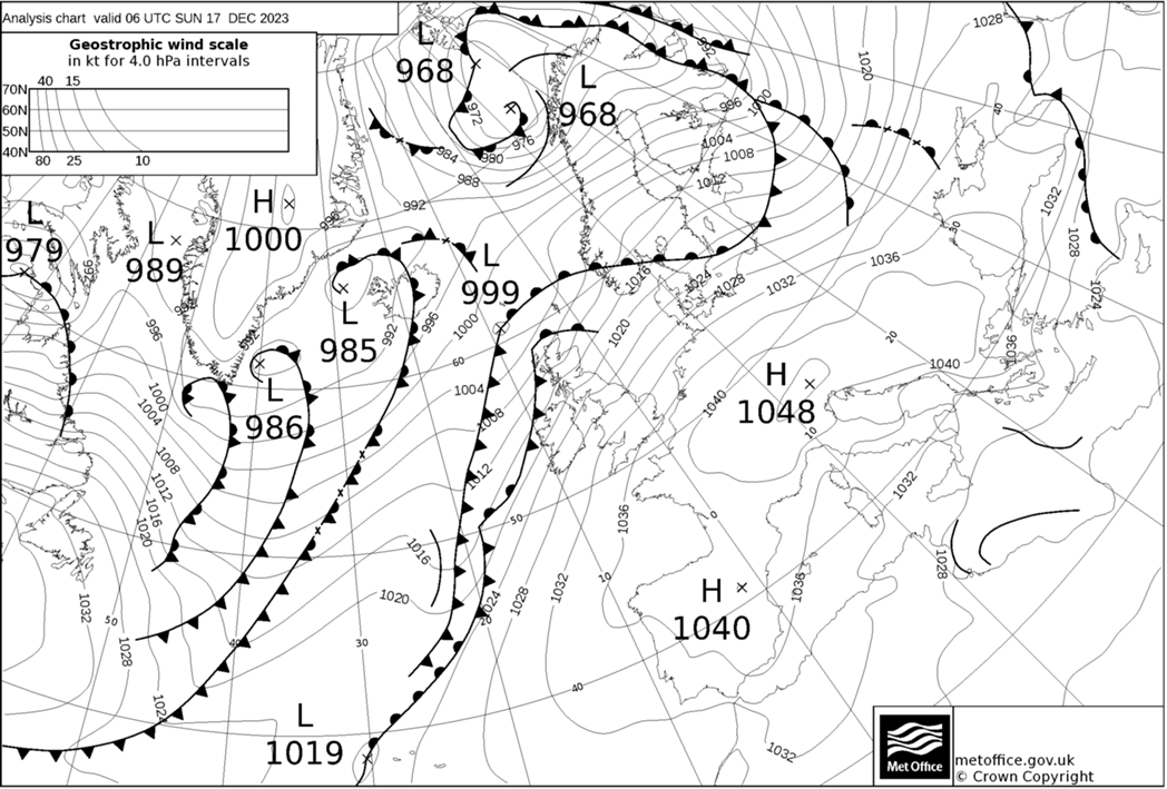
The Met Office has issued an amber weather warning for heavy rain across the Highlands and western Scotland as the rain persists. Some areas can expect another 80 to 180mm, causing further flooding and travel disruptions. However, Eastern Scotland will be less wet, with brighter spells, especially in the lee of the mountains.
Forecast rainfall totals from 6am Sunday to 6am Monday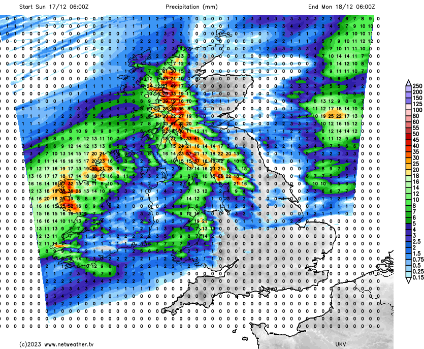
In Northern Ireland, the North and West are currently experiencing rain that will spread to much of the province throughout the day and perhaps to Cumbria later. In the remainder of England and Wales, parts of the East enjoyed maximum sunshine yesterday, marking another mainly dry day. These regions, along with areas sheltered such as the lee of the Welsh mountains, should see further sunny intervals today. However, cloud cover will fluctuate, with the West being overcast at times.
Although somewhat lighter in the South, most parts will experience quite breezy conditions, with gale-force gusts across Scotland, the North West, and exposed areas. Temperatures will be very mild almost everywhere, mostly ranging between 10 and 13C, possibly reaching 14C locally.
After dark, much of Scotland and Northern Ireland will briefly see clearer skies, but further showers are likely, chiefly in the North and West. Elsewhere, wet weather over Cumbria will spread to other parts of northern England, the North and West of Wales, and perhaps as far south as the Midlands by morning. Although decreasing somewhat over Scotland and Northern Ireland, a south to south-west wind will remain quite fresh across England and Wales, ensuring another mild night with temperatures from North to South not falling below 7 to 11C.
As we approach the final working week before Christmas, Monday will see three weakening bands of showery rain moving slowly south and east across the country. Between them, brighter weather will emerge, offering some sunshine. Later, the West of Scotland will experience heavier rain. A south-westerly wind may continue to be blustery in the South, but temperatures will remain very mild for most, around 7 to 11C in the North and as high as 12 or 13C further South.
The northern half of the country is likely to see clearer skies after dark, with a few showers in a west or south-westerly breeze. Although chillier, temperatures should not fall below 4 to 6C. Meanwhile, the Midlands and South will experience rain or showers, with a deepening disturbance potentially bringing heavier bursts into the South West and South by morning. Temperatures here are expected to stay no lower than 7 to 11C.
Orographic rainfall is a meteorological phenomenon that's particularly relevant to the United Kingdom's varied topography. In the context of the northwest of Scotland, this type of rainfall is quite common and impactful. When moist air from the Atlantic Ocean is driven towards Scotland, it encounters the highlands and mountainous regions of the northwest. As this moist air ascends the slopes of these mountains, it cools and condenses, leading to the formation of clouds and heavy rainfall. This process is especially pronounced in the western Highlands, where the terrain rises steeply from the coast, forcing the air to rise rapidly.


.jpg?w=350)


.jpg?w=175)