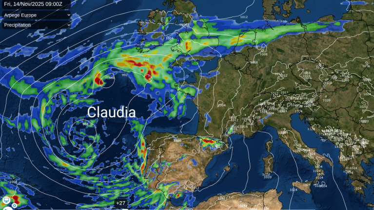
Another autumnal low is looming large on the weekend pressure charts. Not a feisty, vicious one but a slow-moving Atlantic cyclone lumbering in from the west with wind and rain. There will also be milder air brought our way, so a change from the chilly air with a touch of frost over northeastern Britain early on Friday.
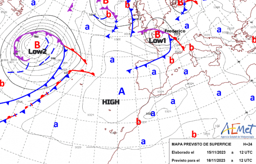 Before the weekend's large-scale low pressure, a problematic low passes along the English Channel on Thursday. This has been named 'Frederico' (2 e's) by Meteo France. As this clears, it leaves a lull for Friday with fine weather before the cloud thickens up and things turn damp through Friday evening. Currently, Friday evening looks cold with a few clear spells further northeast but becoming wet and blustery for Cornwall and Northern Ireland after dark.
These two low pressures dominate the weather across Europe during the weekend. There has been heavy rain in recent weeks and any more water just adds to the flooding risk or existing standing water. The far north of France rarely drops its red flood warning after a bombardment of heavy rain following Storm Ciaran. Many parts of the UK have seen large rainfall totals this month and in October which means that any more heavy rain will have flooding impacts and heighten the risk of trees falling in strong winds.
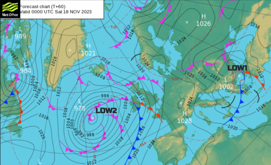
 Low 1 will bring more rain and gales to the Channel Islands, it has been quite the month here. There is uncertainty about how much of southern England, even southern Wales will see rain on Thursday, it’s a tricky bit of the forecast. The low then surges across mainland Europe, through France and northern Spain, into Germany and the Alps. By Friday over the Adriatic to the Balkans and central Mediterranean with a northerly flow and rain into eastern Europe. From there it will move over the Black Sea and Turkey by Saturday with a path of wind, rain and mountain snow across the continent.
Low2 takes its time but that means more widespread rain and wind for the UK and a potentially soggy spell on Saturday and showers following on from the west into Sunday.
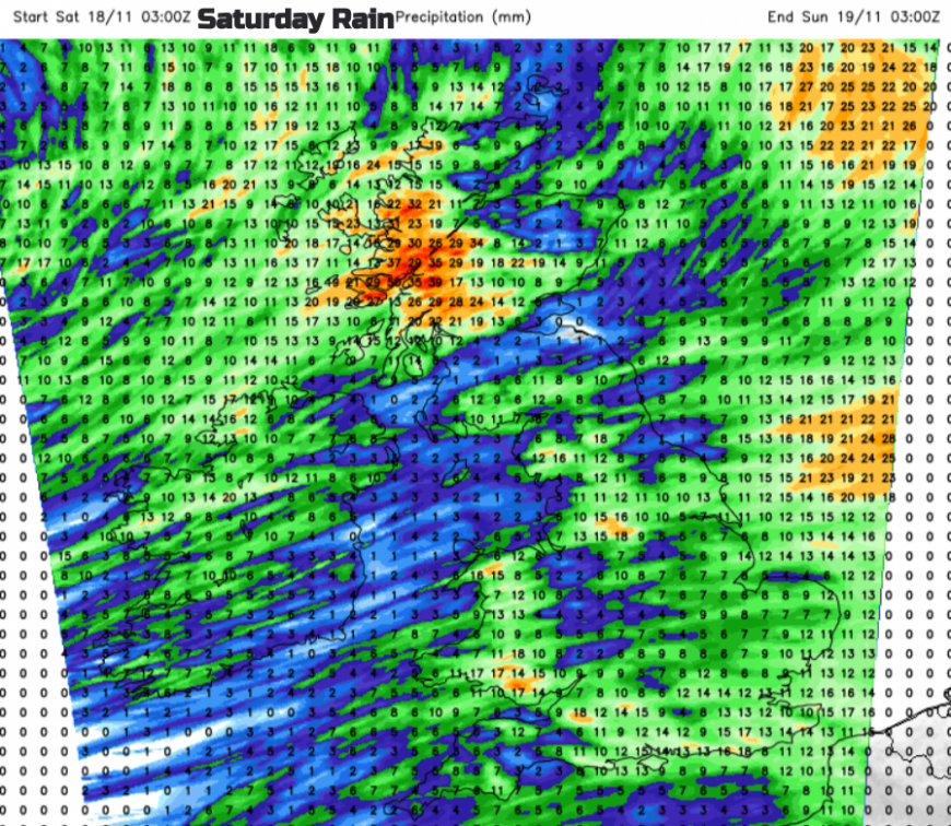
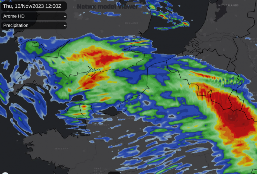
For Saturday, there could be a bit of dry weather with increasing cloud over Grampian and East Anglia. On current timings the main frontal rain should pass over Ireland and SW Britain on Friday night, then the rest of Britain during Saturday. Don’t cling to weather app timings too much for a definite dry clearance at this stage. Just consider a sweep eastwards of the main band of rain. The southerly wind will freshen for eastern Britain during the morning with other parts of the UK already windy. Around the Irish Sea and North Channel, winds will be strong and southeasterly for a time.
Gradually as the frontal rain pushes across to the North Sea and over SE Britain in the afternoon, the blustery winds will veer more to the southwest. There could be brief glimpses of brightness but overall there will be a lot of cloud post-front, further outbreaks of rain and heavy showers from the west. Temperatures will be around 8 to 14C and possibly up to 16C if any brightness appears, the flow is from the south/southwest. Western Scotland looks particularly wet overnight as the low centre and occlusion gets closer and the air over the UK doesn’t look cold.
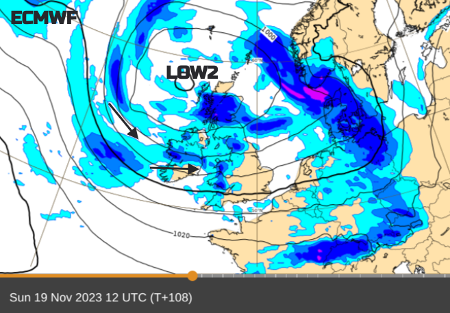
The southerly winds look very light over Scotland on Sunday morning as the low nears. The rest of the UK will be in a moderate to fresh southwesterly wind which veers to a cooler westerly later in the day. It is a messy forecast picture for Sunday with variable amounts of cloud, outbreaks of rain and showers in the flow around the low. Having a look at the radar on Sunday morning will give a good guide on how things are going if you want to pop out for a walk or bike ride. Eastern areas could see some brighter shelter, even sunshine. Western shores are more likely to see the showers and will feel cooler in the wind. Temperatures will be around 11 to 15C.
Loading recent activity...