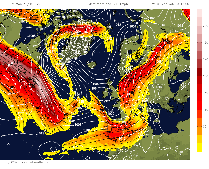
Storm Ciaran has been explosively deepening this afternoon over the North Atlantic to the southwest of Ireland. Prior to this, a gradual deepening occurred since the low left NE USA on Monday, riding a strong 200mph jet stream. But today the low has moved on to the cold side of the jet stream and into the ‘developmental’ Left Exit region.
Watch Storm Ciaran low's journey from NE USA over last few days before it rapidly deepens today as it moves into onto the cold side of the strong jet stream and also into the left developmental exit:
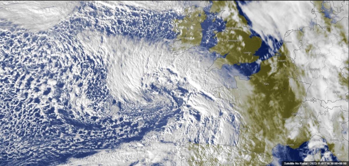
Storm Ciarain can be seen brewing to the southwest over the N Atlantic late afternoon on satellite. The Met Office Fax chart for 6am showed it was 981mb, expected to fall to 954mb midnight, 00z (midnight) this morning it was 988mb, 37mb drop in 24hrs. Explosive cyclongenesis or 'weather bomb' is >24mb in 24hrs! The 12z (noon) fax chart shows a central pressure of 972mb.
The left exit of the jet stream is where winds are diverging or spreading out rapidly 5 miles up in the troposphere the air will rush outward rapidly, this acts like a giant chimney, meaning that air from the surface has to rise to fill the void aloft in the jet’s left exit, causing surface pressure to fall rapidly, helping to deepening the low. The stronger the jet stream – the more rapid deepening there will be in the jet left exit. But there are also other process at work that aid in the deepening of the low, which are too technical to go into detail in this blog, but one of these is very dry descending from the upper atmopshere and moving into the rear of the low as a 'dry slot' - which helps to deepen it. Also, the surface convergence near the centre of the low when air is diverging aloft can manifest in convection leading to latent heat release – which further deepens the low.
.jpg?w=800)
This deepening of the low in turn means winds strengthen around the developing Storm. The peak deepening phase of Storm Ciaran will, unfortunately, occur as the storm makes landfall over SW England tonight. Lowest central pressure varies between models, ECMWF has lowest central pressure at 953mb, GFS has as low as 949mb. This is close to the lowest pressure recorded in southern England - which was 948.8mb on 25th Feb 1989, at Portland, Dorset.

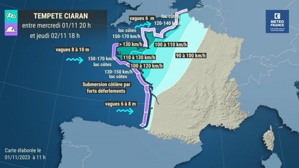
Weather models now coming to a consensus of forecasting extremely strong gusts over NW France and through the English Channel, the strongest gusts towards the west of the Channel, including the Channel Islands.
12z AROME wind gusts (charts from wxcharts.com)
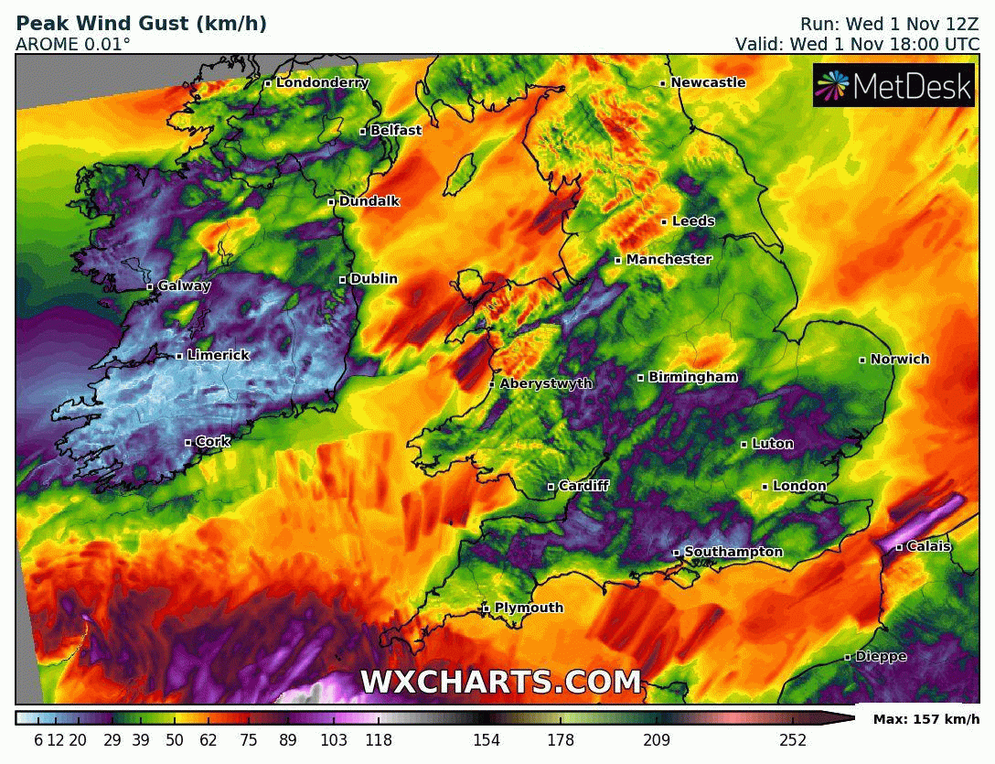
NW France, more particularly coasts of Brittany and east into Cherbourg Peninsula, likely to see wind gusts around 100mph along exposed coasts and headlands tonight. But also similar gusts look to reach the Channel Islands in the early hours of Thursday. A Red Wind Warning for the Channel Islands has been issued by the Jersey Met for gusts of up to 85 knots or 98mph.
Some models, such as 12z UKV and ICON, are also showing a very strong northwesterly wind across Cornwall, as the low clears east, gusting to 80-90mph, while across Devon, gusts are shown to reach 70-80mph Thursday morning.
12z UKMO show some alarming wind gusts for western English Channel, including the Channel Islands

The strong winds spreading further east through the morning through the English Channel to Kent , gusts reaching 60-70 along the south coast, perhaps 80mph+ with exposure such as Portland Bill and Isle of Wight Needles. East Kent could see 70-80mph gusts.
The Low then looks to slow down later on Thursday as it leaves the jet left exit, loitering over the North Sea just of the eastern coast of England into Friday. This could mean rain bands and showers could linger over parts of England after initial swathe of heavy rain moves north and east across England and Wales tonight – with a risk of locally significant rainfall in places could occur falling on already saturated ground and draining into already high river levels. Widely 20-40mm may fall Thursday and Friday, while some places could see 40-60mm over 48 hours.
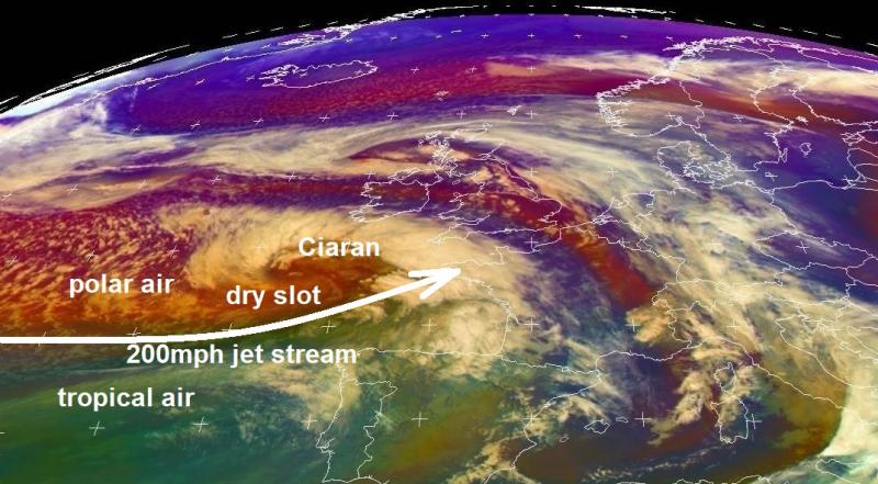
The beginnings of Storm Ciaran can be traced back to a shallow low that developed over the Ohio Valley, USA back on Sunday along a strong baroclinic zone separating cold arctic air surging south over North America from northern Canada and warm tropical air to the south . The low then emerged over the NW Atlantic off New England on Monday evening before heading over the North Atlantic over the last few days, before hitching a ride on the strong 200mph jet stream.
There has been some comparisons of Storm Ciaran with the Great Storm of 16th October 1987. However, there are some fundamental differences. The 1987 storm was an Shapiro-Keyser Cyclone type low, that developed within a split in a strong jet stream and a highly confluent trough, deepening in right entrance-left exit couplet with huge pressure rises behind the trough and also a rare ‘sting jet’ punching into the deepening low generating the violent winds.
https://resources.eumetrain.org/satmanu/shapiro_keyser_cm/index.html
Storm Ciaran follows the more ‘classic’ cyclone Norwegian model, with no split jet and diffluent trough. The rapid deepening acquired by the low crossing a powerful jet on to its cold side and in to a left exit region.
Loading recent activity...