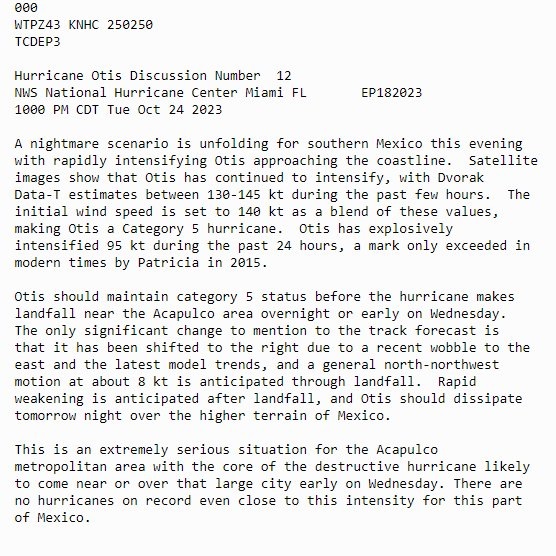
With low pressure moving in close to the west over the coming days, it will become windy and remain unsettled with showers or longer spells of rain. Over in Mexico, Hurricane Otis makes landfall near Acapulco as a catastrophic Cat 5 storm, following unexpected strengthening over last 24 hours.
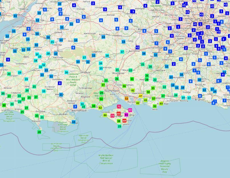
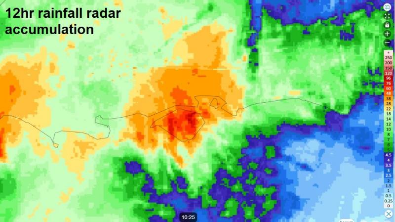
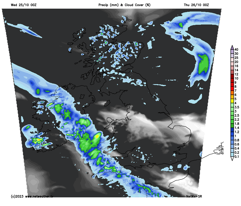
Persistent and heavy rain is again causing some issues this morning, this time across central southern England – where an Amber Warning has been issued. The Isle of Wight and central southern parts of Hampshire are under the warning – where the Netweather Radar accumulations show the highest totals over the last 12 hours. It’s been raining heavily here and much of central southern England for much of the night, with rain still falling, so could be some issues on the roads with flooding in these areas this morning. But the weather models have not forecast this rain very well at all. The rain should clear southeast from southern England this morning then for most it will be largely dry and sunny, though it will be cloudy with patchy rain in the northeast.
Over in Mexico, Hurricane Otis made landfall earlier this morning near the resort city of Acapulco on the southern Pacific Coast, with sustained winds of 165 mph and higher gusts, while bringing up to 10-15 inches of rain. The hurricane is unprecedented for this part of the world, with no hurricanes on record anywhere close to the intensity. Otis was just a tropical storm 24 hours ago before strengthening into a category five hurricane. Otis formed only on Sunday as a tropical depression over the Pacific off the coast of southern Mexico.
Below is a chilling discussion written by the US National Hurricane Center of what is evidently a nightmare scenario for the popular seaside tourist resort Acapulco, which has a population of around 1 million.
Back home and more detail on the weather for today. Torrential rain overnight across Hampshire and the Isle of Wight is leading to some flooding issues for the morning commute, hence the Amber Warning issued by the Met Office earlier this morning but has now expired. The Isle of Wight has seen the highest rainfall totals, with some rain gauges on the island recording over 70mm in 12 hours, one recording 84mm. The island’s railway along the east coast has been suspended between Ryde and Shanklin due to flooding, with roads on the island also affected by flooding in places.
Data courtesy of Starling Roost Weather
The rain is now easing over central southern England and will tend pull away southeast into the English Channel this morning. Otherwise a damp, misty and murky morning across much England and east Wales, with patchy drizzle here and there. Also, some areas of fog across central and eastern England to watch out for, these could be slow to clear. Grey and damp with patchy rain across NE England and eastern Scotland too.
But across more western areas of Wales, Scotland and N. Ireland - some brightness or sunshine here this morning, These drier and sunnier conditions will eventually filter further east across Wales and much of England this afternoon after the grey and misty morning across southern and eastern areas. However, eastern Scotland and NE England will hang on to grey skies with shower rain accompanied by a brisk easterly wind. Temperatures ranging between 10-12C in the north to 13-14C in the south.
Through this evening and overnight, a band of rain will push northwards and eastwards across Ireland, N. Ireland, England and Wales, some heavy showers following across the southwest. Northern England northwards across Scotland staying mostly dry away from eastern coasts – where it will remain cloudy with further patchy rain or drizzle. Strong winds in the far northeast.
Band of overnight rain moving north and east will move north across eastern England and eastern Scotland through Thursday – bringing a wet day here. Otherwise, sunny spells developing, but also some heavy showers, with hail and thunder locally, towards southern and western coastal areas of England and Wales. Western Scotland staying mostly dry and sunny. Temperatures reaching 11-15C.
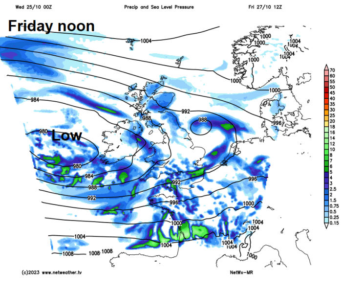
As we move through Friday, low pressure will move in close to the west of Ireland, so it will be a windier day. Most of the UK will have sunny spells but also scattered heavy showers will affect southern and western coastal areas, with a risk of hail, thunder and localised flooding from these. Some of the showers will get inland, but central and eastern areas may stay mostly dry.
The weekend is looking rather unsettled and windy, with low pressure close to the west bringing showers or longer spells of rain across many parts, perhaps a spell of heavy rain moving through southern areas on Saturday, in association with a secondary low, but some uncertainty over track of this low. Despite this, it will remain mild.
Loading recent activity...