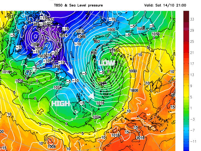
For England and Wales, there is more rain today but it will clear away to the southeast for the main part of the weekend. In its place, there will be chill from the north, a plunge of Arctic air steered by a deepening low pressure which is moving from the Faeroe Islands to Lapland. There will be snow showers for northern Scotland on Saturday and Saturday night.
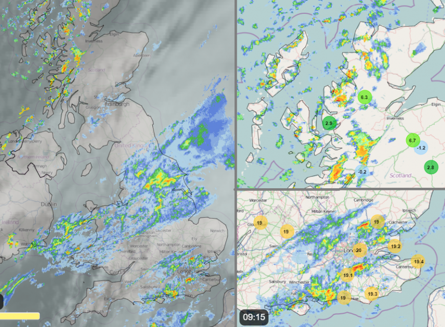
The main rain bands are from a mid-Atlantic low which is heading for the English Channel. There are some flood warnings for south Wales this morning and there will be another pulse of heavy rain at lunchtime as the frontal band sinks southwards. The rain from the Western Approaches will invigorate and Cornwall, Devon and South Wales will see some hefty downpours. There is also an area of more showery rain over southeast England this morning which continues to move eastwards today. It is larger than the UKV model has been showing so keep an eye on the radar if you are popping out later morning in London or Kent. There will also be a fresh southwest wind, so not the best of weather today.
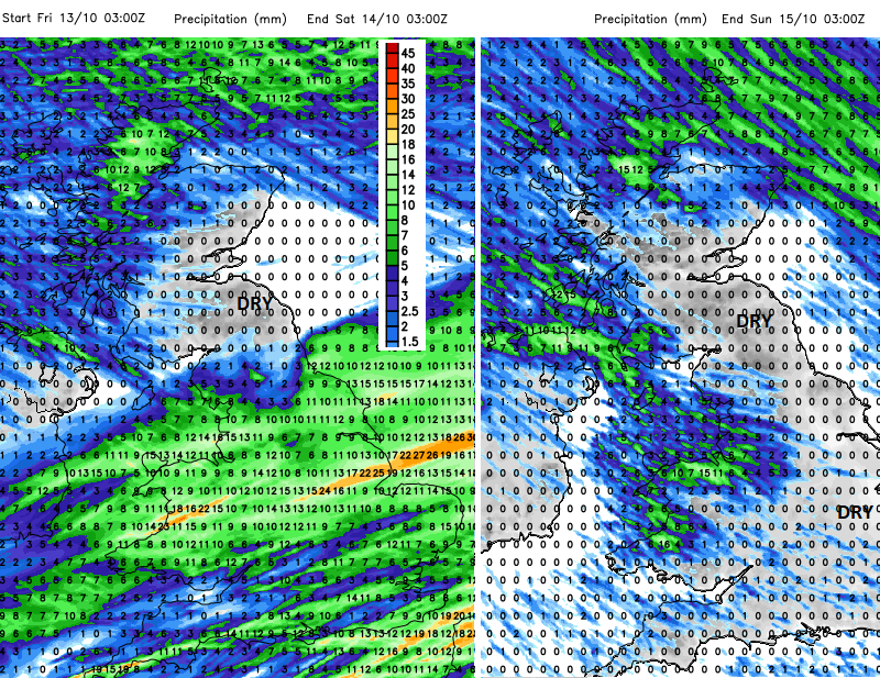
Rain affected areas today, frontal rain over Wales, Midlands and Lincolnshire, with showery rain to southeast, heavy showers in far NW. Drier for most tomorrow although with a scattering of showers for western parts.
Heavy rain and strong winds may cause some disruption to travel during Friday. Met Office
There is still a Met Office warning for heavy rain out until Friday evening but north Wales, Manchester and Leeds should all be clear of the rain by mid-afternoon. The heaviest rain will be increasingly focused towards southeast England as the band clears. The last of the heavy downpours looks to be away from Kent by 10pm and this week’s warm air will be gone. It leaves a cold, clear night with NW gales for the far northeast of Scotland, even severe gales tonight for the Northern Isles. Some ferry cancellations have already been announced.
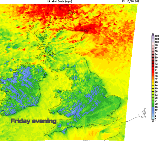
Gales and very rough, even high seas tonight around Northern Isles
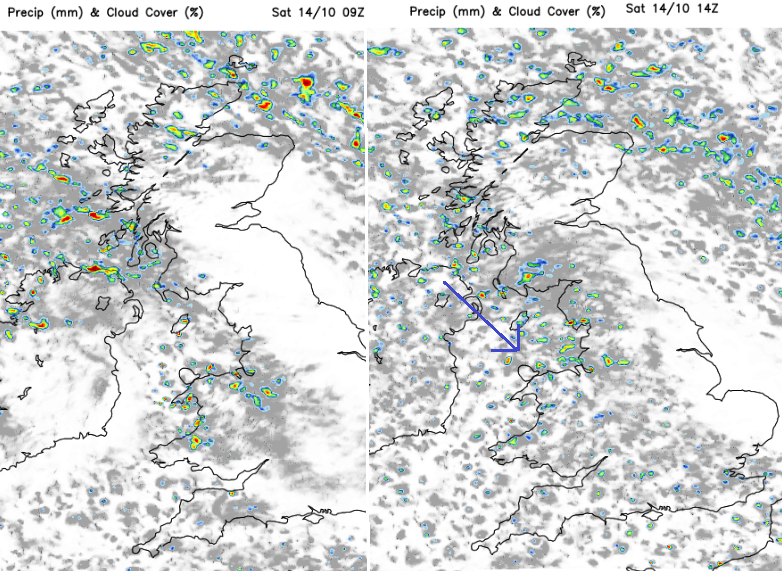
This cold northwest wind will drive in showers for northern and NW Scotland, to Northern Ireland and later in the night, they will reach north Wales and the Isle of Man. By Saturday morning there will be a scattering of rain showers reaching Liverpool and areas around the North Sea, pushing through the Cheshire Gap and into more of Wales as the showers over Highland Scotland turn to wet snow.
 Feed of showers on Saturday in northwesterly wind
It will feel colder everywhere but there will be bright sunshine and a mostly dry day. However, there will be a peppering of showers, mainly for the far north and western Britain and Northern Rieland, although a few will push further inland even reaching southern England by the afternoon. A brisk wind will continue for northeastern Britain during Saturday but not as strong as overnight.
By Saturday night the winds will be easing, and there will be clear skies and colder air over the UK. Northern Scotland will see wintry showers with a little snow settling over the hills and mountains. There will be a frost for some rural inland spots away from the cloud in the far north.
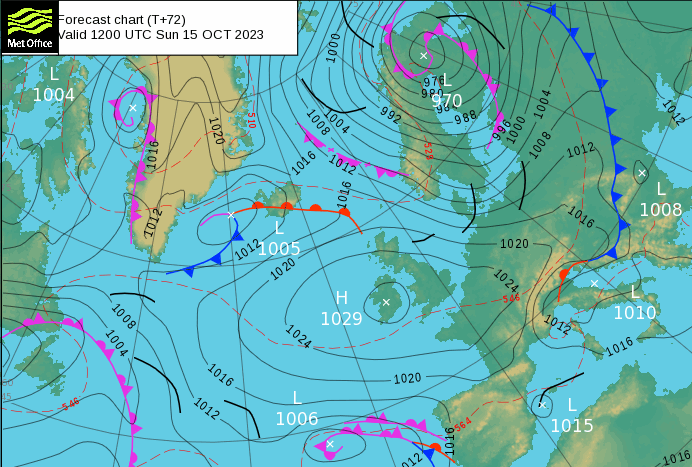
High pressure will be building in from the west on Sunday and will then dominate the weather into the new week. So the outlook is dry and cool.
There will be a westerly wind for northern Scotland and an easterly wind along the English Channel but in-between, winds will be light. Showers will continue for Scotland, from the west on Sunday and increasingly turn to rain as the colder air drifts away. Sunday looks bright or sunny and dry for most. Temperatures will be around 9 to 13C, it will feel very different to last weekend. Just don’t be fooled by the sunshine through the window. The Icelandic word Gluggaveður, translates as ‘Weather window’ when it may look lovely outside but feels very different.
Loading recent activity...