Blustery showers then bright spells with warm sunshine for this weekend. Low pressure will be lurking with freshening winds as the changeable theme to summer continues.
The UK remains stuck in a fresh flow from the Atlantic with hefty downpours which clear to bright spells and warm sunshine. One minute you need a raincoat or brolly, the next it is feeling warmer and more like summer. There is no sign of the southern Europe heat coming our way but there will be some fine, dry times for the end of the week. These will be sandwiched in between bands of rain from a stubborn low pressure.
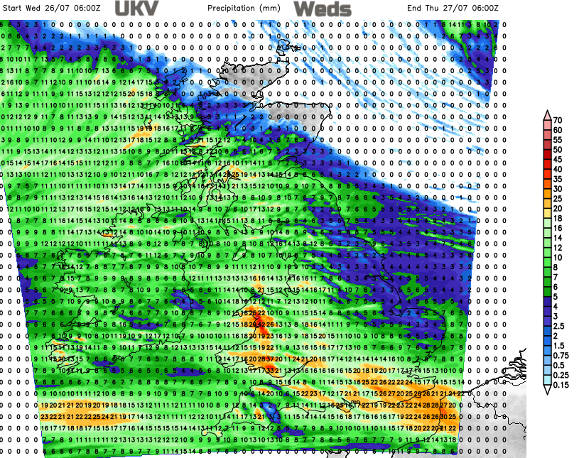
The actual low centre will move across the UK at the weekend. The initial warm front is already bringing rain and cloud across Ireland on Wednesday morning. This rain spreads across much of Britain later today with heavy downpours for Wales and overnight for southern England. Within the warm sector, it will feel quite close and humid.
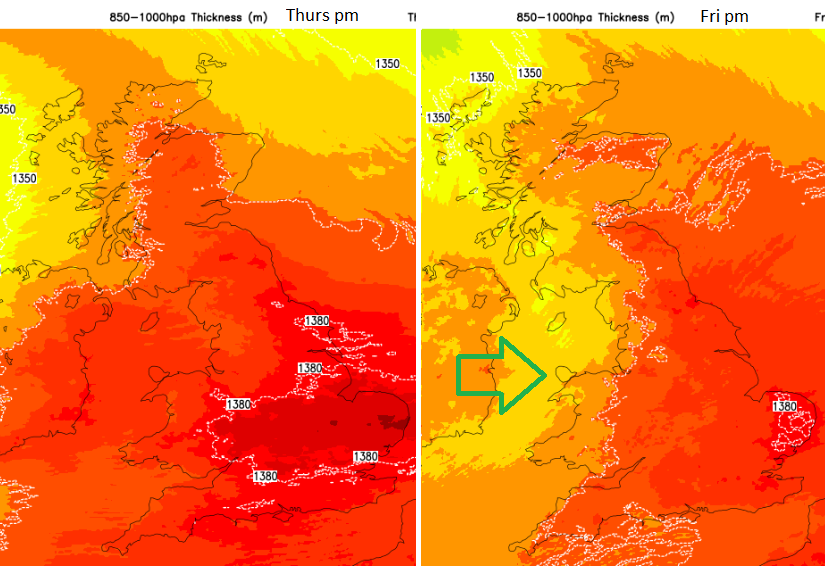
Temperatures will rise into the low to mid-twenties Celsius on Thursday. Eastern England will cling on to the warmer air and the slightly muggy feel to things for Friday.
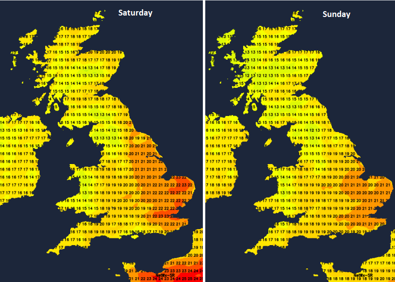
For the weekend sheltered eastern areas could still manage 21 or 22C in any sunny spells on Saturday. For Sunday it will be back to how it’s felt this week with 15 to 21C across the UK.
All of this will depend on where the frontal bands are, with their cloud and rain depressing the temperature values. Then jumping up in good sunny spells.
As the active warm front moves over northeastern Scotland on Thursday, the rest of the UK is left with a showery westerly flow, bright spells and perhaps a convergence line of heavier showers for the counties of southern England. There is then a lull overnight into Friday before scattered showers get going again. The low centre will still be swirling away off the northwest of Scotland.
For Friday evening the showers from the southwest begin to pep up. There will be light winds overnight but by Saturday morning the south to south-westerly winds will be picking up and gusty around any showers. Western Britain will see more blustery showers, and further east it will feel warm in sunny spells and to the lee of high ground. Northern Ireland will be windy on Saturday with a fresh south-westerly wind and plenty of showers rattling by.
West coasts Scotland and Cumbria will see more showers overnight as the winds pick up for Dumfries & Galloway and across the Irish Sea.
There are some drier areas, northeast coasts of Scotland, inland parts of England
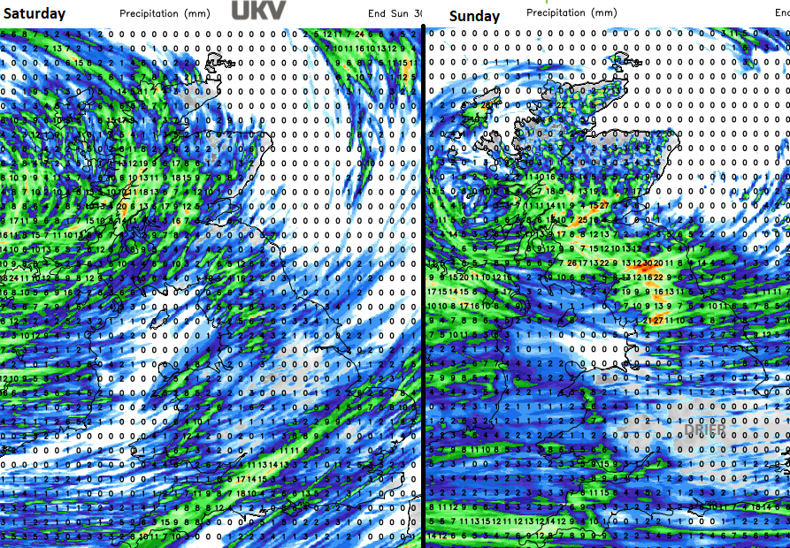
The centre of the low will finally move across southern Scotland during Saturday night with some heavier and persistent rain as it trudges eastwards.
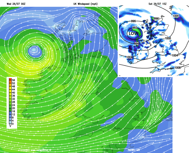
Like last weekend there could be some shift in which part of Britain sees the worst of the rain, maybe a bit further north or south. Forecasts show that southern Scotland and the far north of England will bear the brunt of the frontal rain on Sunday morning. It will be windy for Northern Ireland, Wales and England, especially along Irish Sea coasts. Northern Scotland could see some warm sunshine with much lighter winds before the showers get going again.
Northern Ireland should brighten up on Sunday afternoon and there will be plenty of fine weather for southern and eastern Britain. Wales will still see a few blustery showers and there will be a rash of showers for northern England and Scotland but with the focus transferring to NE Britain by Sunday evening. That is as the next frontal system could be sliding into southwest Britain with more cloud and patchy rain. It’s all unsettled but there will be warm sunshine at times, it’s just not real summer heat.