July, in contrast to June, has been changeable, wet, dull and often on the cool side for the UK. But will some of the heat over southern Europe come our way? Models suggest this is unlikely over the next few weeks, as an active jet stream off the Atlantic keeps the heat to the south.
July so far hasn’t offered any prolonged hot weather in the UK and has been predominantly cool and changeable. A far cry from July last year, especially in the middle third, when 40.3C was recorded in Coningsby in Lincolnshire on the 19th. This July, the highest temperature so far this month was 30.2C at Chertsey, Surrey on July 7th. Since then, temperatures have struggled to get past the mid-20s, 25C reached in the south last Wednesday and again this Sunday, otherwise the low twenties at times in the south at best. Saturday the 15th saw an unusually deep low for mid-July bring gales to parts southern Britain, with gusts of 45-55mph.
Last weekend saw a washout across the south on Saturday and washout across northern areas of England on Sunday, with 99mm (nearly 4 inches) falling in 24 hours at Preston in Lancashire. Cool and changeable at best this week, with showers in the east today and rain spreading across all parts tomorrow, then another unseasonably deep low spins in off the Atlantic across the north on Saturday, bringing a windy, cool and showery weekend. And it looks to remain cool, breezy and unsettled through next week too.
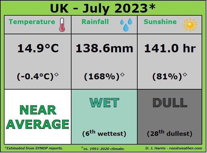
Despite this, rolling average temperature for all 4 UK nations for July so far is close to average, rainfall has been well above for all 4 nations, while it's been duller than average for England, Wales and N. Ireland, but near average sunshine for Scotland.
 Data from Starling Roost Weather
This is in stark contrast to southern Europe, that continues to bake in extreme heat. Yesterday 48.2C was recorded at Jerzu on the Italian island of Sardinia - a new European record high temperature for July. 47.8C at Syracuse in Sicily.
On the boundary of the extreme heat over southern Europe and cooler air over northern Europe to the north of the Alps, violent thunderstorms have erupted over recent days across Switzerland, northern Italy, Austria, Slovenia and Croatia. Yesterday, a 135 mph gust measured at La Chaux-de-Fonds airport, in far west of Switzerland during the morning, when a severe thunderstorm swept through causing much damage in the town not far from the French border in the Jura mountains. Last night violent storms also swept east across northern Italy, causing wind damage and dropping giant hail, one hailstone picked up northeast of Venice was reportedly 19cm in diameter!
The jet stream has been separating the hot air over southern Europe and cooler air over northern Europe, including the UK. The jet stream yesterday was running west to east across southern France and the Alps and provided the strong vertical wind shear combined with warm and humid air drawn in from the Mediterranean that caused the severe storms over the Alps and northern Italy.
Jet stream aimed at NW Europe will keep the UK and Ireland changeable and often cool for the foreseeable
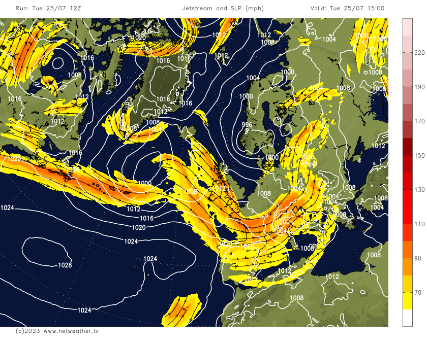
Although the jet stream looks drift a little further north across Europe the rest of this week, the UK remains on the cool side of it most of the time. The west to east jet stream flowing in off the Atlantic will be close by for the rest of this week, over the weekend and through much of next week - bringing further frontal systems with outbreaks of rain and occasionally some depressions with strong winds, like is modelled for the weekend moving across the north. If anything, the jet stream looks to crank up a gear next week, looking at GFS. A strong zonal jet stream aimed at the UK, as shown in the chart below, does not portend to summery weather – cool, breezy or windy and showery, with occasional longer spells of rain look likely next week. Though there will be occasional drier and sunnier spells.
So, we could be looking at a July that is cooler than June, not difficult when June was the warmest on record in the UK, but a July cooler than June hasn’t happened since 1970!
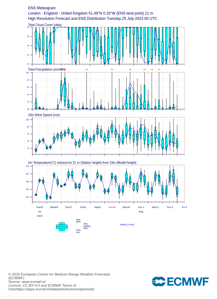
In the short to medium range there are no signs from this morning’s ECMWF ensemble members for London 2m temperature of any heat on the way rest of this month and up 4th August. Perhaps the odd day nearing 25C.
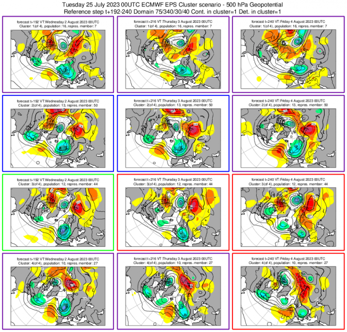
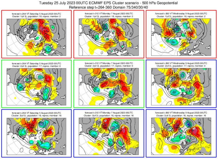
00z ECMWF clusters show a ridge moves in from west at times, between troughs, though look fairly transient, so any settled weather may not be long-lasting.
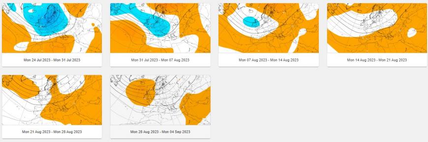
In the longer range, the ECMWF weeklies, published last night, showed troughing dominating over NW Europe right through to at least mid-August. Though confidence in model projections more than 2 weeks out is low. But it’s probably fairly safe to say that hot weather is unlikely in the next few weeks and perhaps through to mid-August. The jet stream looks to remain pointed at the UK and, at times, further south into France.
500 hPa heights (blue low heights / troughing - orange higher heights )
2m temperatures (blue below average)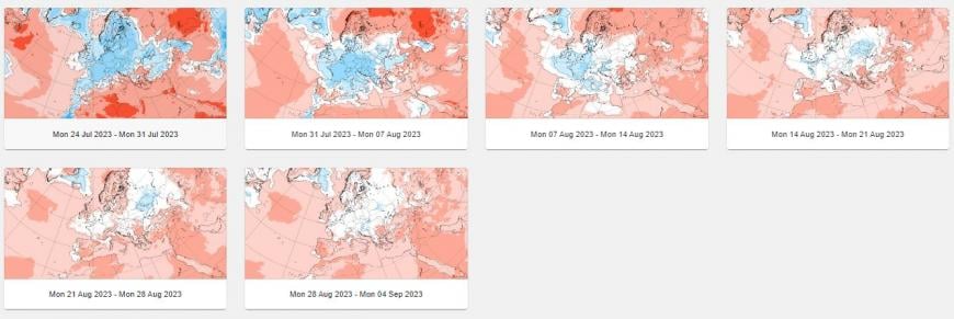
This is in contrast to last July, when the polar jet stream was well north of the UK, with a cut-off low to the west, which allowed hot air to be pumped to the UK from North Africa and stagnate for days.
So if you see tabloid news stories proclaiming that the southern European heat is on the way to the UK over the next few days, take with a pinch of salt.
Loading recent activity...